Sierra Leone
Area 27,699 square mi (71,740 square km)
Population 6.316 million (2014)
Capital Freetown
Highest Point 6,390 ft (1,948 m)
Lowest Point 0 m
GDP $4.838 billion (2014)
Primary Natural Resources diamonds, gold, titanium ore, bauxite.
LOCATED ALONG the north ATLANTIC OCEAN in western Africa, Sierra Leone borders the Republic of GUINEA and LIBERIA. Most of the country's coastline is made up of a belt of low-lying mangrove swamps broken here and there by numerous estuaries and some wide, sandy beaches.
The exception to this is a mountainous zone on the Sierra Leone Peninsula, where the capital, Freetown, is located. Behind the coastal belt is a wooded plateau that averages about 1,000 ft (300 m) in height. The eastern half of the country toward the Guinea border is relatively mountainous and includes Bintimani Peak, Sierra Leone's highest point at 6,390 ft (1,948 m).
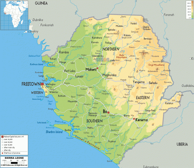
Several rivers, including the Great Scarcies and the Mano, flow through the country to the Atlantic. The headwaters of the NIGER RIVER are also situated in the mountains of the northeast. The landscape has several distinctive physiographic regions: a low-lying, relatively flat coastal-swamp zone along the Atlantic that is subject to frequent flooding; the Sierra Leone Peninsula, a region of thickly wooded mountains that rise from coastal swamps to an elevation of 2,913 ft (888 m) at Picket Hill; the featureless interior plains with broad grasslands, rolling wooded country, and a rocky scarp and hill country; and a large plateau region that includes the Loma Mountains, crowned by Mount Loma Mansa (Bintimani Peak) and the Tingi Hills, which rise to 6,079 ft (1,853 m) at Sankanbiriwa Peak.
WET AND DRY SEASON
The climate is definitely tropical with high temperatures and humidity. Normal rainfall can be quite heavy especially during the Atlantic's hurricane season. Along the coast where rainfall is the heaviest, especially on the Peninsula Mountains, as much as 200 inches (5,080 mm) may fall annually. The dry season lasts from November to April, and the wet season constitutes the remainder of the year, with maximum precipitation from July to September.
Sierra Leone is self-sufficient in timber and about one-tenth of the land is arable and roughly 30 percent of the total land is committed to permanent pasture. Mineral resources are fairly widespread. Alluvial diamonds can be found along the upper reaches of the Sewa River where they have been mined since the 1930s. Other important mineral deposits include iron ore, bauxite, chromite, and rutile.
In 2002, the country ended a decade of civil war through the efforts of British and United Nations peacekeeping forces. The peacekeeping forces were able to disarm thousands of rebels and militia fighters. Into the 21st century, the country is undergoing a rebuilding process, including the formation of a Truth and Reconciliation Commission to address atrocities committed by the warring factions.
Black settlers founded the capital city, Freetown, under the auspices of the British. The first settlers were known as the Black Poor, a group of 400 people from England in 1787. Shortly thereafter, former slaves from jamaica and other parts of the Caribbean arrived in Freetown; they had gained their freedom by fighting with the British during the American War of Independence. The descendants of Sierra Leone's black settlers blended African and British lifestyles into a distinctive Krio, or Creole culture. Besides speaking English, they developed their Krio language, which has become the nation's lingua franca. Today, the Krio make up only 5 percent of the country's multiethnic population.