Svalbard and Jan Mayen
Two territories of the kingdom of NORWAY, Svalbard and Jan Mayen are outposts for hunting, mining, and scientific activity far to the north of most human settlement. The islands are located north and northwest of Norway, within the southern limits of Arctic sea ice— the northernmost point of Svalbard is within a 620 mi (1,000 km) of the North Pole. Svalbard is approximately 24,570 square mi (63,000 square km); Jan Mayen is approximately 145 square mi (373 square km).
Svalbard is an island group consisting of nine main islands: Spitsbergen (the largest), Nordaustlandet, Barentsoya, Edgeoya, and smaller islands, plus the small island of Bjornoya further to the south. Spitsbergen has Svalbard's only settlements, the Norwegian administrative capital of Longyearbyen and nearby Barentsburg, the Russian mining community. Jan Mayen is a single island, dominated by a towering active volcano, Beerenberg, which had its last eruption in 1985. It is located off the eastern coast of GREENLAND, 370 mi (600 km) north of ICELAND.
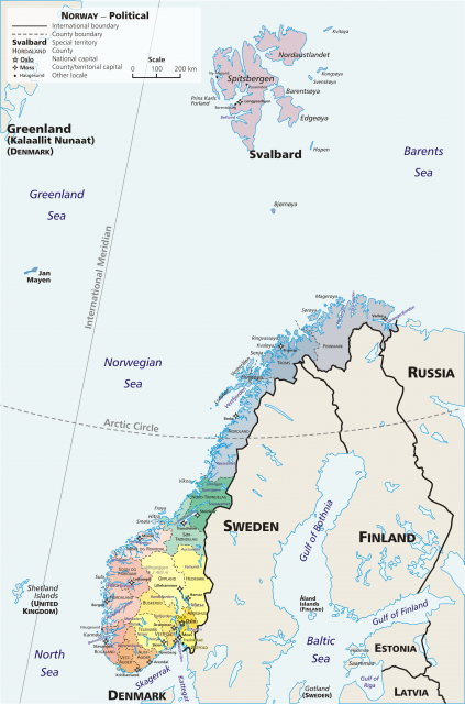
Neither location has much vegetation; they are barren but for some moss and grass. About 60 percent of Svalbard is covered by glaciers, and its terrain consists primarily of mountains and fjords. Both have modified climates for their extreme northern latitude, thanks to the influence of the GULF STREAM which brings warmer water from as far away as the Gulf of Mexico. The point where the warmer southern waters mix with the cold Arctic waters, particularly in the western coasts of Svalbard, provides rich feeding grounds for seals and whales, the primary initial attraction to human exploration of the region, as early as the 12th century. Willem Barents explored the islands in 1596.
Jan Mayen was discovered in 1614 by a Dutch whaling captain, Jan Jacobs May van Schellinkhout, though the Vikings may have known of its existence earlier. Whaling was the predominant activity in the 19th century. Coal became the primary commodity in the early 20th century, with the establishment of the first mine by John M. Longyear (giving his name to Longyearbyen) in 1906. The Svalbard Treaty of 1920 recognized Norway's sovereignty and forbids naval bases or fortifications but gives the other 40 signatories equal mineral exploitation rights. Only RUSSIA currently maintains a mine operation, but it seems to be for as much political reasons as economic. Neither Russia's nor Norway's mines are very profitable, so it is reasonable to suspect their presence is simply insurance given Svalbard's proximity to northern ports and shipping lanes. Other economic activity includes some trapping of foxes and even polar bears.
Norway claimed sovereignty over Jan Mayen in 1929, having continually run a meteorological station since 1921. It is administered separately from Svalbard through the Norwegian Defense Communication Service. Aside from the main radionavigation system LORAN (Long Range Navigation), built by NATO (NORTH ATLANTIC TREATY ORGANIZATION) in 1959, Jan Mayen is also home to several scientific stations, including seismographic stations near Beerenberg, the northernmost active volcano in the world. NORSAR was set up to verify compliance of signatories of the Comprehensive Nuclear Test Ban Treaty using sensitive seismic measurement equipment.