The Ice Age
Glaciation occurs when temperatures fall in regions of ample snowfall, allowing ice to accumulate and build. Although glaciation is a general term for the glacier growth and landform modification produced by glaciers, here we use it to refer to the period when continental ice sheets grow and spread outward over vast areas.
When the climate warms or snowfall decreases, ice sheets become thinner and cover less area. Eventually, the ice sheets may melt completely. This period is called a deglaciation. After a deglaciation, but before the next glaciation, there is a mild-climate period, or an interglaciation.
The last interglaciation began about 140,000 years ago and ended between 120,000 and 110,000 years ago. A succession of alternating glaciations and interglaciations, spanning 1 to 10 million years or more, makes up an ice age.
The most recent ice age is but one of several ice ages the Earth has experienced in its long history. Although there is some evidence for an ice age near the start of the Proterozoic Eon, about 2.5 billion years ago, the earliest well-documented ice age took place from about 800 to 600 million years ago, near the end of that eon.
That glaciation may have been quite extensive, with a “snowball Earth” that had sea ice nearly to the Equator. A minor ice age occurred in the late Ordovician Period, around 450 million years ago, and extensive polar ice caps and alpine glaciers formed twice during the Carboniferous and early Permian periods.
Throughout the past 3 million years or so, the Earth has been experiencing the Late-Cenozoic Ice Age (or, simply, the Ice Age). About 50 years ago, most geologists associated the Ice Age with the Pleistocene Epoch, which began about 1.6 million years ago. But new evidence from deep-sea sediments shows that the glaciations of the Ice Age began in late Pliocene time, perhaps 2.5 to 3.0 million years ago.
At present, we are in the middle of an interglaciation of the Ice Age, following a deglaciation that set in quite rapidly about 15,000 years ago. In the preceding glaciation, called the Wisconsinan Glaciation, ice sheets covered much of North America and Europe, as well as parts of northern Asia and southern South America. The maximum ice advance of the Wisconsinan Glaciation was about 18,000 years ago.
Figure 17.19 shows the maximum extent to which North America and Europe were covered during the last advance of the ice. Most of Canada was engulfed by the vast Laurentide Ice Sheet, which then spread south into the United States.
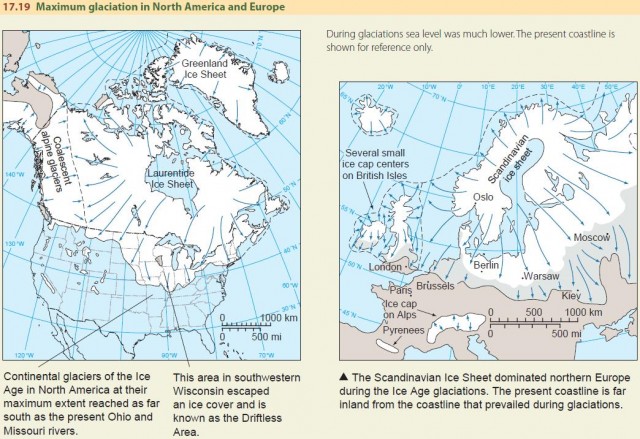
ice caps on the southern Andes Range south of about latitude 40° S and spread westward to the Pacific shore, as well as eastward to cover a broad belt of Patagonia. The South Island of New Zealand, which today has a high spine of alpine mountains with small glaciers, developed a massive ice cap in late Pleistocene time. All high mountain areas of the world developed alpine glaciers. Today, most remaining alpine glaciers are small ones.
In Europe, the Scandinavian Ice Sheet centered on the Baltic Sea, covering the Scandinavian countries, and spread south into central Germany and far eastward to cover much of Russia. The European Alps were capped by enlarged alpine glaciers. The British Isles were mostly covered by a small ice sheet that had several centers on highland areas and spread outward to coalesce with the Scandinavian Ice Sheet.
Looking carefully at the maps in Figure 17.19, you can see that the ice sheets seem to extend far out into what is now the open ocean. This is because the sea level was as much as 125 m (410 ft) lower than today, exposing large areas of the continental shelf on both sides of the Atlantic Basin. The exposed continental shelf had a vegetated landscape and was populated with animal life.
The weights of the continental ice sheets, covering vast areas with ice masses several kilometers thick, pushed down on the crust. This created depressions of hundreds of meters at some locations. When the ice melted, the crust began to rebound—and is still rebounding today in some locations.
INVESTIGATING THE ICE AGE
In the 1960s, geologists made a great scientific breakthrough that helped them study the glacial history of the Ice Age. First, they developed a technique for taking long sample cores of undisturbed fine-textured sediments of the deep ocean floor. Then they discovered how to use signs of ancient magnetism to discover how old the sediment layers were. The Earth's magnetic field experienced many sudden reversals of polarity in Cenozoic time, and the absolute ages of these reversals are known with certainty. By observing these reversals in the sediments, they were able to date the layers accurately. They also studied the composition and chemistry of the core layers, creating a record of ancient temperature cycles in the air and ocean.
Deep-sea cores reveal a long history of alternating glaciations and interglaciations going back at least 2 million years and possibly 3 million years. In late-Cenozoic time, there were more than 30 glaciations, spaced about 90,000 years apart. We don't know how much longer this sequence will continue—possibly for 1 or 2 million years, or even longer.
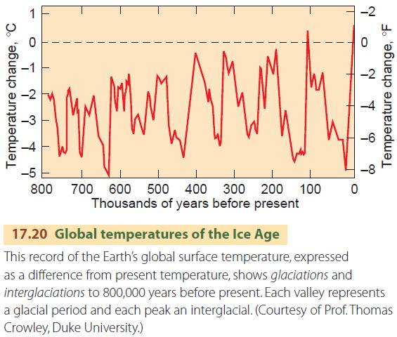
Figure 17.20 presents a plot of global temperature going back to about 800,000 years ago. Each valley represents a glacial period and each peak an interglacial. The figure clearly shows five distinct glaciations and four interglaciations since about 500,000 years ago. Before that time, the record shows more frequent glacial cycles that are somewhat less extreme.
POSSIBLE CAUSES OF THE ICE AGE
What caused the Earth to enter into an Ice Age? There are at least four possible explanations. The first is related to plate tectonics, the second to volcanoes, the third to changes in the Sun's energy output, and the fourth to changes in atmospheric composition.
The explanation related to plate tectonics suggests that the motions of lithospheric plates after Pangaea broke apart were responsible for the Ice Age. In Permian time, only the northern tip of the Eurasian continent projected into the polar zone. But as the Atlantic Basin opened up, North America moved westward and poleward to a position opposite Eurasia, while Greenland took up a position between North America and Europe.
The plate motions brought an enormous area of land to a high latitude, surrounding the polar ocean. This reduced, and at times totally cut off, the flow of warm ocean currents into the polar ocean, encouraging ice sheets to grow. The polar ocean would have been icecovered for much of the time. At the same time, the average air temperatures in high latitudes would have lowered enough for ice sheets to grow on the encircling continents.
In addition, Antarctica moved southward during the breakup of Pangaea and took up a position over the South Pole, where it was ideally placed to develop a large ice sheet. Some scientists have also proposed that the uplift of the Himalayan Plateau—caused by the collision of the Austral-Indian and Eurasian plates—modified weather patterns and triggered the Ice Age.
Volcanic activity has also been suggested as a possible cause of the Ice Age. Eruptions produce dust veils that linger in the stratosphere and block solar radiation. Perhaps an increase in volcanic activity on a global scale in late-Cenozoic time temporarily cooled near-surface air temperatures, somehow triggering the start of the Ice Age. The geologic record does confirm that there were periods of high levels of volcanic activity in the Miocene and Pliocene epochs, but no triggering mechanism has been demonstrated.
The third proposed cause of the Ice Age is a slow decrease in the Sun's energy output over the last several million years. This could form part of a slow cycle of increase and decrease over many millions of years. As yet, we don't have enough data to identify whether this mechanism was responsible. But research on this topic is being stepped up as satellites give us new knowledge of the Sun and its changing surface.
The last cause is a change in atmospheric composition. We have seen how greenhouse gases act to warm the Earth, and a reduction in greenhouse gases could cause an Ice Age. However, the concentration of greenhouse gases is determined by a complicated process of interaction and feedbacks between biological and physical processes and can change on a rapid time scale.
Although there is some evidence that greenhouse gas levels have fallen at the start of ice ages and increased at their end, it's not certain just how or why such changes might have taken place.
For now, most scientists seem to agree that tectonic plate movements that affect oceanic and atmospheric circulation are at least necessary, if not sufficient, for an ice age to occur.
POSSIBLE CAUSES OF GLACIATION CYCLES
What timing and triggering mechanisms are responsible for the many cycles of glaciation and interglaciation that the Earth is experiencing during the present Ice Age? Although many causes for glacial cycles have been proposed, in this book we'll just discuss one major contender, called the astronomical hypothesis. It has been under consideration for about 40 years and is now widely accepted.
The astronomical hypothesis is based on the motion of the Earth in its orbit around the Sun—which is now well established (Figure 17.23). The Earth's orbit around the Sun is an ellipse, not a circle. We call the point in the orbit nearest the Sun the perihelion, and the point farthest from the Sun the aphelion. Today, the Earth is at perihelion around January 3 and aphelion around July 4. But astronomers have observed that the orbit slowly rotates on a 108,000-year cycle, so the absolute time of perihelion and aphelion shifts by a very small amount each year. In addition, the orbit's shape varies on a cycle of 92,000 years, becoming more and less elliptical. These cycles change the Earth–Sun distance and therefore the amount of solar energy the Earth receives at each point during the year.
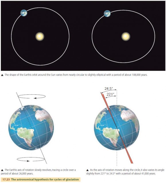
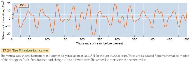
The Earth's axis of rotation also experiences cyclic motions. The tilt angle of the axis varies from about 22 to 24 degrees on a 41,000-year cycle. The axis also “wobbles” on a 26,000-year cycle, moving in a slow circular motion much like a spinning top or toy gyroscope. These cycles in axial rotation and solar revolution mean that the annual insolation experienced at each latitude changes from year to year. Figure 17.24 shows a graph of summer insolation received at 65° N latitude for the last 500,000 years as calculated from these cycles. The graph is known as the Milankovitch curve, named for Milutin Milankovitch, the astronomer who first calculated it in 1938.
Looking at the figure, you can see that the dominant cycle of the curve has a period of about 40,000 years. But notice that every second or third peak seems to be higher. Dating methods using ancient ice cores and deep lake sediment cores tell us that the peaks at about 12,000, 130,000, 220,000, 285,000, and 380,000 years ago correspond with the rapid melting of ice sheets and the onset of deglaciations. Most scientists studying climate change during the Ice Age now agree that these cyclic insolation changes explain the cycles of glaciation within the Ice Age.
HOLOCENE ENVIRONMENTS
About 10,000 years have elapsed since the Wisconsinan Glaciation ended. We call that time period the Holocene Epoch. It began with a rapid warming of ocean surface temperatures. Continental climate zones then quickly shifted poleward, and plants recolonized the glaciated areas.
There were three major climatic periods during the Holocene Epoch leading up to the last 2000 years. These periods are inferred from studies of fossil pollen and spores preserved in glacial bogs, which show changes in vegetation cover over time. The earliest of the three is the Boreal stage, characterized by boreal forest vegetation in midlatitude regions. There followed a general warming until the Atlantic stage, with temperatures somewhat warmer than today, was reached about 8000 years ago (–8000 years). Next came a period of temperatures that were below average—the Subboreal stage. This stage spanned the age range –5000 to –2000 years.
We can describe the climate of the past 2000 years on a finer scale, thanks to historical records and more detailed evidence. A secondary warm period occurred in the period A.D. 1000 to 1200 (–1000 to –800 years). This warm episode was followed by the Little Ice Age, A.D. 1450–1850 (–550 to –150 years), when valley glaciers made new advances and extended to lower elevations.
Global temperatures have been slowly warming within the last century and are now starting to warm even more rapidly due to the release of greenhouse gases by human activity. As we saw in our opening section, Eye on Global Change – Ice Sheets, Sea Ice, and Global Warming, global warming is bringing major change to glaciers and sea ice. This is but one effect of the global climate change now being brought about by human activities. There will be many others.