Thunderstorms
A thunderstorm is any storm that produces thunder and lightning. At the same time, thunderstorms can also produce high winds, hail, and tornadoes. They are typically associated with cumulus clouds that indicate the presence of rising, unstable air. It is this rising motion that produces the characteristic rainfall and lightning that accompany thunderstorms. Thunderstorms can range from fairly isolated, short-lived storms, sometimes called air-mass thunderstorms, to massive, well-organized complexes of storms, called mesoscale convective systems.
Air-mass thunderstorms are isolated thunderstorms generated by daytime heating of the land surface.
They occur in warm, moist air that is often of maritime origin. Triggered by solar heating of the land, they start, mature, and dissipate within an hour or two. Formation stops at night, since surface heating is no longer present.
The typical life cycle of an air-mass thunderstorm involves three stages of development (Figure 4.28). In the cumulus stage, unequal surface heating causes air parcels to rise. Isolated cumulus clouds form as the parcels reach and pass through the lifting condensation level. At first, these clouds dissipate as they mix with the surrounding dry air, which evaporates the cloud water droplets. However, this process cools the air aloft and raises its moisture content, creating instability.
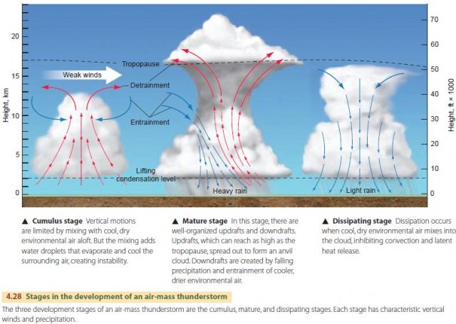
As instability increases, convection reaches greater heights and soon a thunderstorm develops. In this mature stage, there are both updrafts and downdrafts. The updrafts carry the cloud high into the atmosphere, where upper-level winds draw the cloud downwind to create a characteristic anvil cloud.
Downdrafts are created when water droplets become large enough to fall through the cloud and drag the surrounding air downward. Downdrafts can also be caused by the movement of cooler, drier surrounding air into the cloud from the upwind side. This cooler air tends to sink. It is further chilled by the evaporation of cloud water droplets, increasing the sinking motion. At ground level, the downdraft spreads forward, forcing more warm moist air up and into the cloud.
Eventually, the stabilizing effects of the movement of surrounding air into the cloud overcome the destabilizing effects of convection. Widespread downdrafts form that inhibit upward motion and suppress latent heat release, cutting off the power source of the storm. This is the dissipating stage.
Air-mass thunderstorms are initiated by surface heating during the day. They start, mature, and dissipate within an hour or two. Formation stops at night, since surface heating is no longer present.
Lightning is also generated by convection cell activity. It occurs when updrafts and downdrafts cause positive and negative static charges to build up within different regions of the cloud. Lightning is a great electric arc—a series of gigantic sparks—passing between differently charged parts of the cloud mass or between the cloud and the ground. The electric arc heats the atoms of the air along its path, causing an explosive expansion and producing the sound we hear as thunder.
SEVERE THUNDERSTORMS
Severe thunderstorms persist longer than air-mass thunderstorms and have higher winds. They often produce hail or even tornadoes. Although they may start as simple airmass thunderstorms, they reach a mature stage and then intensify rather than dissipate. In the severe thunderstorm, large amounts of cooler, drier environmental air enter the cloud from the upwind side, creating a strong downdraft (Figure 4.29). As the downdraft spreads out in front of the storm, it creates a gust front. The advancing air pushes large volumes of moist surface air upward, feeding the convection. A distinctive roll cloud can form that is visible as the storm approaches.
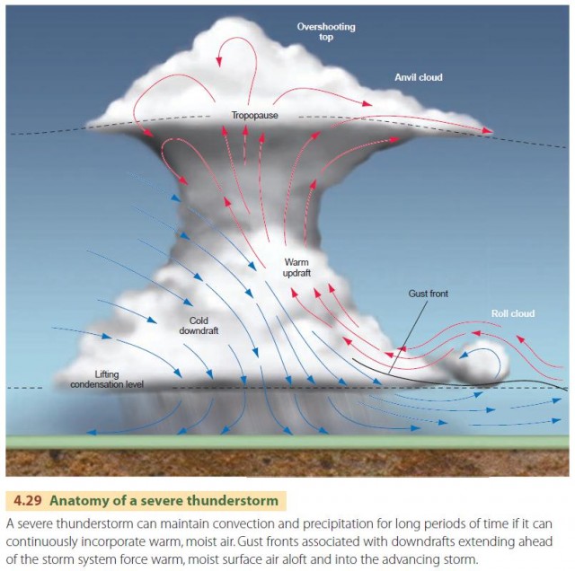
An essential component of the severe thunderstorm is wind shear—a change in wind velocity with height— that keeps cool, dry air entering from the upwind side while the warm, moist, rising air stays on the downwind side of the cell.
Under unusual circumstances involving a temperature inversion aloft, severe thunderstorms can become supercell thunderstorms—massive thunderstorms with a single circulation cell comprising very strong updrafts and downdrafts. Because of their vertical extent, which can be up to 25 km (16 mi), they are affected differently by winds at the surface and winds aloft. If the background wind shear not only involves a change in wind speed with height but also a change in direction—typically in a counterclockwise direction—a rotation of the storm can occur, which is a precursor to the formation of tornadoes.
MICROBURSTS
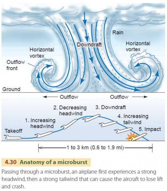
Another characteristic feature of many severe thunderstorms is the formation of a microburst—an intense downdraft or downburst that accompanies the gust front (Figure 4.30). Once the microburst hits the ground, it flows outward in all directions, producing intense, localized winds called straight-line winds or plough winds. A microburst is also often, but not always, accompanied by rain.
The microburst itself can be so intense that it is capable of causing low-flying aircraft to crash. An aircraft flying through the microburst first encounters strong headwinds, which may cause a bumpy ride but does not interfere with the airplane's ability to fly. However, as the airplane passes through the far side of the microburst, it encounters a strong tailwind. The lift of the airplane's wings depends on the speed of the air flowing across them, and the tailwind greatly reduces the air speed, which causes a loss of lift. If the tailwind is strong enough, the airplane cannot hold its altitude and may crash.
Microbursts can be detected by special radar instruments, now installed at many airports, that measure horizontal wind speeds. Training procedures for pilots have also reduced the incidence of aviation accidents in the United States attributed to microbursts and associated wind shear.
MESOSCALE CONVECTIVE SYSTEMS
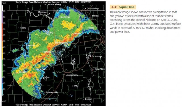
Large, organized masses of severe and supercell thunderstorms sometimes occur under unusual conditions. These are called mesoscale convective systems. In one situation, upper-air wind flow patterns cause air to flow into a region and rise. The rising motion stimulates long-lasting clusters of severe and slowly-moving thunderstorms. In another situation, the change in wind direction with height caused by the approach of a cold front causes air to rise along a line ahead of the front. The resulting squall line of thunderstorms includes storms in different stages of development (Figure 4.31).