Yenisey-Angara River
THE YENISEY AND ANGARA rivers form a dividing line between western and eastern SIBERIA. Like the other major rivers of the region, they flow from highlands in the south across the flat north Siberian plains to the ARCTIC OCEAN. The watershed also includes the subbasin of Lake BAIKAL, the second-largest body of fresh water in the world. Most of the Yenisey-Angara basin is unpopulated because of its severe climate and lack of resources, but a cluster of cities occupy the upper parts of these rivers, where natural resources such as iron ore and gold and the rivers' hydroelectric potential have drawn settlers, mostly from the west, but also some Korean and Chinese immigrants.
The Yenisey-Angara basin covers an area of 996,248 square mi (2,554,482 square km). Nearly half is forested, and the average population density is only 2 persons per square km. There are 10 cities in the basin with populations above 100,000, including Ulan Bator (Ulaanbaatar), the capital of MONGOLIA, which is on the river Orhon, the chief affluent of Lake Baikal. Other large cities include Krasnoyarsk (the regional administrative center) and Abakan on the upper Yenisey, and Irkutsk and Bratsk on the Angara.
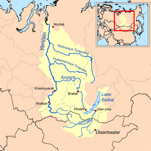
Another city, Norilsk, lies a few kilometers to the east of the river near its mouth in the Yeniseyskiy Zaliv (bay), at the point where the forested Central Siberian Plateau meets the TUNDRA of the Arctic coastal region. The upper reaches of both rivers are mountainous and forested—though the portion of the watershed that extends into northern Mongolia is mostly grassland and arid STEPPE. The source of the Yenisey is in eastern Tuva, an autonomous republic of the Russian Federation, in the Sayan Mountains (where the river is called the Ulu-Khem). From here it flows 2,360 mi (3,806 km) almost directly north to the Kara Sea, an arm of the Arctic Ocean.
The Angara begins as the outlet for Lake Baikal and descends rapidly through gorges. Both this stretch and the upper Yenisey have been harnessed for hydroelectric power, creating large reservoirs at Krasnoyarsk on the Yenisey, and at Bratsk and Irkutsk on the Angara. These electrical and hydrological reserves have been crucial for the development of heavy industry in these areas, notably Krasnoyarsk, one of the coal capitals of Russia.
After the conjunction of the Yenisey and Angara near Yeniseisk, the Yenisey becomes broader and slower as it crosses the Siberian plains. Yeniseisk was once the center of Russia's gold mines and was one of the first outposts of eastward expansion, built in 1618. The river follows the ESCARPMENT of the Siberian Plateau, forming a distinct physical, environmental, and climatic boundary between this hilly region to the east and the vast West Siberian Lowlands to the west. Other tributaries join, mostly from the east, chiefly the Middle and Lower Tunguska rivers. The Yenisey's estuary is about 140 mi (225 km) long. Navigation is possible as far inland as Turukhansk (at the Lower Tunguska), but is hindered by ice for six months of the year. Nevertheless, the Yenisey and its main tributary, the Angara, form some of the only highways in this sparsely populated region.