hemisphere
THE WORD hemisphere means “half a sphere.” In geography, the term refers to half the Earth, and the enclosing boundary line of a hemisphere is a great circle. A space traveler viewing the Earth from a great distance will see only half the earth, a hemispheric perspective. This is true because the Earth is a sphere and only one side of the Earth can be seen in any one particular view.
Our only look at the entirety of the Earth's surface is through world maps. The map view of the world is important for that reason despite the fact that every map 1) is a scaled-down replica of the Earth, 2) presents a generalized view of the Earth's surface, and 3) is a distortion of the Earth's surface to varying degrees. There are an infinite number of possible hemispheric views of the Earth. When an observer looks directly at any particular point on the Earth's surface, a hemisphere is defined. However, there are a number of hemispheres that have special importance for the discriminating viewer. For instance, if the equator is the great circle enclosing a hemisphere, the viewer will be seeing either the Northern Hemisphere or the Southern Hemisphere. In both cases, the center of the hemispheric view will be one of the poles. Viewing the Southern Hemisphere would show vast expanses of the southern oceans, interrupted by the southern extremes of South America and Africa, about half of AUSTRALIA, all of NEW ZEALAND, and a few scattered islands in the PACIFIC OCEAN. In the center of the view would be the geographical South Pole and the continent of ANTARCTICA, a true landmass covered by heavy sheets of ice. For example, South Pole station sits on ice that measures 8,000 ft (2,438 m) in thickness. The presence of a preponderance of water in the Southern Hemisphere has a great impact of the climate in this region. Since large water bodies do not heat up and cool as quickly as comparably sized land areas, the annual changes in temperature are much lower.
The view of the Northern Hemisphere is distinctly different. At the center of the view is the geographical North Pole, a point that is impossible to permanently mark on the surface because of the constant movement of the ice on the Arctic Ocean. South of the pole are the northern regions of the great landmasses of the northern hemisphere. Particularly imposing in this regard is the longitudinal sweep of Eurasia extending over 180 degrees of longitude. RUSSIA alone boasts of having 11 time zones. The northernmost reaches of North America are also prominent in this view, its land area bracketed by the ATLANTIC and PACIFIC oceans. The climatic impact of the presence of large land areas in the Northern Hemisphere is profound. The variability in annual temperatures is extreme in this region. It is not uncommon for areas within the continents of Eurasia and North America to have average winter temperature near 0 degrees F (-17.7 degrees C) and summer averages in the 70 and 80 degrees F (21 to 26 degrees C) range, temperature ranges not found in the southern hemisphere.
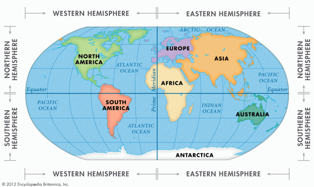
Familiar to everyone are the Eastern and Western Hemispheres. The two are separated by a great circle comprising two longitude lines, both running from pole to pole in opposite directions. The longitude line designated 0 degrees passes through Greenwich, England, and serves as one of the dividers between the two hemispheres. Its counterpart passes through the Pacific Ocean 180 degrees from the prime meridian. Hence, it is identified as longitude 180 degrees. An observer standing at any location along either of these lines is on the boundary between the eastern and western hemispheres. The prime meridian is the conventional starting point for assigning degree values to longitude lines.
The area west of the prime meridian to longitude 180 degrees is the Western Hemisphere. Conversely, the area to the east of the prime meridian is the Eastern Hemisphere. The longitude lines in both Hemispheres are measured in degrees from the prime meridian. Time zones are also directly related to the 360 degrees of longitude. The time of day increases east of the prime meridian one hour for every 15 degrees of longitude. On the other hand, the time of day decreases west of the prime meridian one hour for every 15 degrees of longitude. The longitude line at 180 degrees is identified as the INTERNATIONAL DATE LINE. A traveler crossing the International Date Line in an easterly direction and entering the Western Hemisphere would then be in the previous day. On the other hand, travelers going
from the Western Hemisphere into the Eastern Hemisphere would find themselves in the next day. Although 180 degrees longitude designates the International Date Line, the line is displaced to the west at one point in order to include the Aleutians and keep all of Alaska in the same day. Similarly, the line is displaced to the east in the southern Pacific Ocean to include the Cook Islands in the same day as Australia and New Zealand.
Two additional hemispheric views illustrate the land and water hemispheres. If a globe is oriented so that the Cook Islands in the South Pacific are in the center, the water hemisphere may be seen. This is the hemisphere that has the maximum amount of water in view. In addition to a few islands in the South Pacific, the only land areas visible are portions of Australia, Antarctica, and South America. All of New Zealand is seen. The water hemisphere perspective clearly illustrates the enormous extent of the Pacific Ocean.
If the globe is oriented with the country of Turkey in the center, then the land hemisphere comes into view. In this perspective the viewer is seeing the hemisphere that has the maximum land area. The entire continent of Africa is present as well as South Asia, Europe, and a large part of the Asian landmass to the east. In addition, the eastern portion of North America is in view.