Political Geography
A HUMAN PERSPECTIVE Abdoulaye Sowe, a Senegalese farmer, chose a spot to build his new house near the Senegalese border guard's shack. He believed the guard shack was in Senegal. But long-time residents of the area told him that, before the shack was built, a guard used to sit near a tree that was considered the border marker. The tree was several hundred feet north of Sowe's house. Technically, Sowe now lived in the country of Gambia, not Senegal. Sowe's dilemma points out the difficulty of pinpointing borders that create political units.
Nations of the World
Governmental units of the world can be described in either political or geographic terms. Generally, we use the political term state to describe an independent unit that occupies a specific territory and has full control of its internal and external affairs. Often the term “country” is used to mean state.
Nation refers to a group of people with a common culture living in a territory and having a strong sense of unity. When a nation and a state occupy the same territory, that territory is called a nation-state. Many countries of the world are nation-states. However, it is possible for a nation not to have a territory. When that happens, the group without a territory is called a stateless nation. Examples of stateless nations include Palestinians, Kurds, and Basques.
TYPES OF GOVERNMENT
All countries must choose a type of government.
Generally, the type of government falls into one of these categories:
- Democracy Citizens hold political power, either directly or through elected representatives. Example: the United States.
- Monarchy A ruling family headed by a king or queen holds political power and may or may not share the power with citizen bodies. Example: the United Kingdom or Saudi Arabia.
- Dictatorship An individual or group holds complete political power. Example: North Korea or Afghanistan.
- Communism In this government and economic system, nearly all political power and means of production are held by the government in the name of all the people.
Whatever the type of government, it must deal with issues that have to do with the territory and people of the state.
Geographic Characteristics of Nations
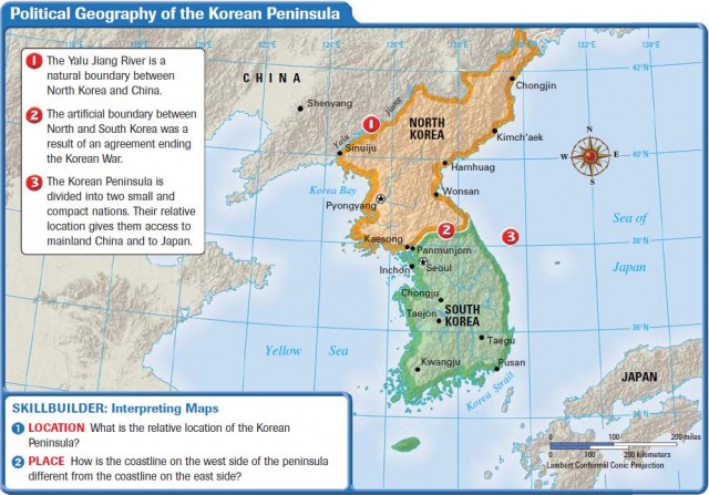
Three geographic characteristics are very important in describing a country. These characteristics are: 1) size, 2) shape, and 3) relative location. The combination of these characteristics makes each nation unique. By looking at the map above, you will see how these characteristics helped shape the political geography of the Korean Peninsula.
SIZE
You might assume that the physical size of a country has much to do with its wealth and power. However, this is not always true. For example, the political division of the United Kingdom known as England once controlled a significant empire of colonies around the globe. Even so, a larger nation, such as the United States, China, or Russia, has the potential to be more powerful because it has more resources and people on which to build military or economic power.
SHAPE
Countries can be compact, such as Germany, or long like Chile. Some countries are fragmented, like Japan, which is made up of many islands. The shape of a country can have an impact on how easily it can be governed, how goods are moved to all areas of the country, and how it relates to neighboring countries.
LOCATION
The relative location of a country can be very important. A landlocked country—one surrounded by other land and with no direct outlet to the sea—must find ways to build connections to the rest of the world to get goods in and out of the country. Bolivia is an example of a landlocked country. In contrast, the location of the tiny city-state of Singapore in Southeast Asia gives it access to major shipping lanes between East Asia and South Asia. The resulting trade brings great wealth to the port. A nation surrounded by hostile neighbors must deal with issues of protection and security.
National Boundaries
Boundaries or borders set the limits of the territory controlled by a state. Within its borders, the state can do such things as collect taxes, set up a legal code, and declare an official language. A state may claim all of the resources found within its boundaries. Because so much is at stake, states are very protective of their borders. The two basic types of national boundaries are natural and artificial.
NATURAL BOUNDARIES
A natural boundary is based on physical features of the land, such as rivers, lakes, or chains of mountains. The Rio Grande, for example, is a river that forms a natural boundary between part of Mexico and part of the United States. Natural boundaries may seem like an easy way to separate one country from another, but they do present problems. Traditionally, a river or lake boundary is fixed in the middle of the body of water. What if a river shifts its course? Which country gets additional land—or loses it?
ARTIFICIAL BOUNDARIES
An artificial boundary is a fixed line generally following latitude or longitude lines. The 49°N latitude line that separates the United States from Canada is an example. These lines are often formally defined in boundary treaties between countries.
Sometimes a conquering country imposes boundaries on lands it has taken over. The lines established may not match boundaries previously found in that location, which can lead to internal problems or even war. Africa is a good example of how boundary lines can divide groups of people or put groups that have long been enemies together in one state.
When parts of Africa were divided by European colonial powers in the 1800s, the boundary lines for Nigeria included the traditional lands of the Hausa-Fulani people, the Yoruba people, and the Ibo people. Under British control, the three groups were forced to follow British rules. When Britain left, there was controversy over the control of the lands. One group, the Ibo, attempted to withdraw from Nigeria and form its own nation-state—Biafra. A civil war resulted, and the attempt to split away failed.
Regional Political Systems
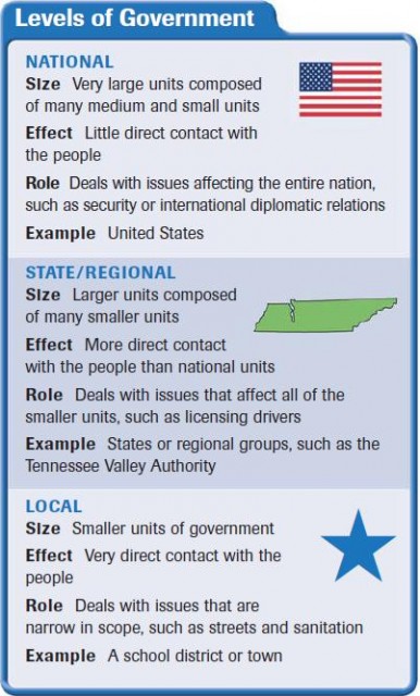
Countries often are divided into smaller political units to make governing more efficient. The most common local units of government are cities, towns, and villages. Other types of political units might include school districts.
Smaller political units often combine to form larger regional units, such as counties, provinces, and states. Here, too, there may be districts for providing a service or product to an area that crosses several political units. For example, the Tennessee Valley Authority (TVA) regulates water usage in a seven-state region.
Countries may join with each other to form international political, military, or economic units. Groups of states within a regional area may band together to promote mutual goals.
The largest political unit is the United Nations, which has nearly 200 members who work to improve political, cultural, and economic conditions across the globe. In the next section, you'll learn that almost half of the world's population lives in urban areas that include political units called cities.