Zagros Mountains
THE ZAGROS MOUNTAINS are a complex chain of mountains and ridges in the westernmost part of IRAN. The range divides the region between the fertile plains of Mesopotamia and the Persian Gulf lowlands to the west, and Iran's dry inland plateau to the east. The ridges run roughly northwest to southeast, 930 mi (1,500 km) in length, from Kurdistan to the Straits of Hormuz. Called Kuhha ye Zagros in Persian, the peaks and valleys of this range have provided a fertile home for the Persian people since prehistoric times and an effective barrier to the expansive tendencies of their more richly endowed neighbors to the west in the FERTILE CRESCENT. Some of the oldest and most important Persian cities are within the bounds of these mountains: ISPHAHAN, Persepolis, Shiraz, and Kermanshah. Today, most Iranians live in the broad valley between the Zagros ranges and the Kuhrud Mountains, a parallel range about 186 mi (300 km) to the east.
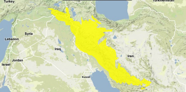
The Zagros Mountains are roughly the same age and have the same formation history as the ALPS— caused by folds in the Earth's crust as the African and Arabian plates collided with the Eurasian Plate over 100 million years ago. The different ridges each have their own particular characteristics: in the central foothills of the western side of the range are the primary oil fields of Iran. Salt domes are also common in the center of the range, some as tall as 5,000 ft (about 1,500 m). The southern ranges tend to be lower, below 13,200 ft (4,000 m), with more limestone rock. The tallest mountains, those over 14,850 ft (4,500 m), are located in the center of the range, including the tallest peak in the range, Zardeh Kuh (14,920 ft or 4,548 m). The Zagros range, in general, is characterized by sheer rugged peaks and steep canyons and gorges.
The mountains encompass several lakes as well, including Iran's largest inland body of water, Lake Urmia. Few rivers flow year-round, and most of the small streams flow west into the Tigris River basin or across the narrow coastal plain into the PERSIAN GULF and the Gulf of Oman, or eastward into salt lakes, to evaporate in the dry interior.
Because of their elevation, the Zagros Mountains have a more subtropical climate than the drier areas below. Winds from the west bring moisture off the Persian Gulf. There is generally heavy snow in winter, the most in the far northwest, where snow stays on the peaks year-round. Meltwater from winter snows is vital for Iran's water supply. The Zagros Mountains are important environmentally because of their biodiversity resulting from the region's varied topography and climate. An initiative by the government of Iran has been established to protect this diversity and has created several protected areas.