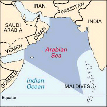
Arabian Sea
THE ARABIAN SEA covers approximately 1,491,000 square mi (3,862,000 square km) and is located between the Arabian and Indian peninsulas in the northwestern area of the INDIAN OCEAN, bounded by INDIA, PAKISTAN, IRAN, OMAN, YEMEN, and the HORN OF AFRICA. The Arabian Sea has been the historic trade route from Occident to Orient since the dawn of commerce between the cradles of civilization. Dhows (sailing vessels) full of spices and slaves have given way to petroleum tankers and container ships, yet the trade continues unabated.
As early as the 8th century and onward, Arabian and Persian mariners learned to navigate this area by using prevailing winds and the surface currents generated by the summer and winter monsoons. For half the year (April–October), the winds in this region are from the southwest, reversing in the other half of the year. This monsoon (season) weather pattern dominates the region on land and sea, setting the pace of commercial activities and much of life.

Commercial fishing is a major activity in the Arabian Sea with the leading species fished being sardines, prawns, and mackerel. India accounts for 23.6 percent of its annual haul mostly from waters 6 to 9 mi (10 to 15 km) from the coast. Fishing stocks are being depleted because of a combination of overfishing and pollution along the Indian coast. Some 65 percent of all fish taken from the Arabian Sea continues to be from local fishermen in traditional boats as their single means of livelihood.
The overexploitation of fish stocks is mostly due to large fishing vessels operating illegally near the coast. The growth of regional populations, particularly India, will add pressure on the already challenged marine resources. This population increase and industrial development create major pollution problems. Industrial effluents contain heavy metals and chemical wastes. Pesticides and organic wastes flow untreated into the coastal waters from cities and agricultural land. Oil pollution from accidents and ballast dumping is on the increase. The nations that share the management and use of the Arabian Sea have no comprehensive plan for conservation and management of the resources or uses of this critical area of ocean.
Primary branches of the Arabian Sea are the Gulf of Oman, which joins it to the Persian Gulf via the Strait of Hormuz and the Gulf of Aden, which joins it with the Red Sea via the BAB EL MANDEB. There are no islands in the middle of the Arabian Sea, where depths average in excess of 9,800 ft (3,000 m). Deep water reaches close to the bordering lands except in the northeast, off Pakistan and India. The deepest known point in the Arabian Sea is at Wheatley Deep, where depths are more than 19,000 ft (5,800 m). The principal waterway draining directly into the Arabian Sea is the INDUS RIVER. Costal islands exist around the Arabian Sea and have proven significant for political and military purposes.
The sea is of geostrategic interest as it is the transit route for a major portion of the world's oil supply. In addition, the commerce flowing by ship from Asia to Europe also sails this sea.