Danubian Gates
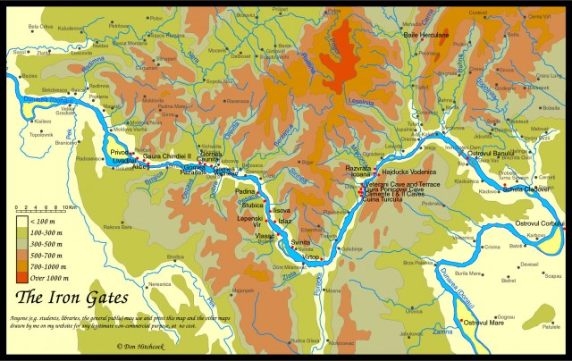
FOR CENTURIES, traffic along the DANUBE RIVER was hindered by a stretch of treacherous rocks and narrow gorges at the point at which the river cut through the Southern Carpathian mountain range. This stretch, about 62 mi (100 km) in length, along the border of ROMANIA and Yugoslavia (SERBIA), is known as the Danubian or Iron Gates, “Portile de Fier” in Romanian, and “Djerdap” in Serbian.
This barrier long formed a boundary between lower river commerce (to the BLACK SEA), and the river traffic of the upper Danube basin. The river flows through crystalline schists, limestones, and Sinaia strata (local Romanian stone), with both dangerous rock outcroppings in the riverbed, dangerous curves, and intense currents as the gorge reaches its narrowest points. The waters were most dangerous during low water periods (summer and autumn), and especially at night, when the height and verticality of the gorge walls allowed for extremely limited visibility.

Man added further dangers over the centuries, with nearly impregnable fortresses built by robber barons and extortionist princes. Most famous of these was the fortress Tri Kule, near Svinita, built by a Transylvanian prince to prevent Turkish infiltrations into the middle and upper Danube areas. But commerce continued. A system of mule tracks and rope attachments were long in operation to drag boats through the area, and as the region freed itself from Turkish rule, several large channel-cutting projects were attempted, most notably by Serbia in 1890–98, with the construction of a series of canals between Virciorova and Gura Vaii, the most dangerous section of the gorges, which introduced the use of trains to pull boats upstream instead of mules. Other projects included the Sip Channel, underwater rock blasting, transverse and longitudinal embankments, beacons, signals, and so forth.
But along with this challenge of commercial transport, governments of the region realized the potential for hydropower also provided by such a concentration of water in a narrow space. More than two-thirds of the Danube basin as a whole lies above the Iron Gates, with a catchment area of 219,089 square mi (567,440 square km) from the Alpine, Dinaric, and Carpathian zones, producing an average flow of 194,936 cubic ft (5,520 cubic m) per second. The Iron Gates Navigational Authority was established in 1948 by Yugoslavia and Romania to examine both issues of facilitated transport and development of hydropower potential. In 1956, this body set out initial plans to build a “hydro-energetical navigational system.” Work was begun in 1964, and full operation began in 1971. This remains the largest hydropower dam and reservoir system along the entire Danube, but as western institutions have begun to have closer access to the region, some wider issues have been raised, notably concerning the system's environmental impact, including upriver silting, downriver erosion, loss of animal habitat and worsening water quality.