continental drift
CONTINENTAL DRIFT INVOLVES large-scale horizontal movements of continents relative to one another and to the ocean basins during one or more episodes of geologic time. The hypothesis of large-scale movement or displacement of continents has a long history. About 1800, Alexander von Humboldt, a German naturalist, noted the apparent fit of the bulge of eastern South America into the bight of Africa. On the basis of this observation, he theorized that the lands bordering the ATLANTIC OCEAN had once been joined. Half a century later, a French scientist Antonio Snider- Pellegrini argued that the presence of identical fossil plants in both North America and European coal deposits could be explained if the two continents were formerly connected, and was difficult to account for otherwise. In 1908, U.S. scientist Frank B. Taylor invoked the notion of continental collision to explain the formation of some of the world's mountain ranges.
Building on the previous arguments, the first comprehensive theory of continental drift was introduced by Alfred Wegener, a German meteorologist. It was unusual that it attracted worldwide attention, caused scores of scientific papers to be written attacking or defending it, and still has many staunch and convinced adherents despite numerous grave theoretical difficulties. It has long been known that the continental portions of the earth's crust consist chiefly of the lighter and more acid rocks; beneath this, it was commonly supposed, there was a layer of denser and more basic rocks.
FLOATING CONTINENTS
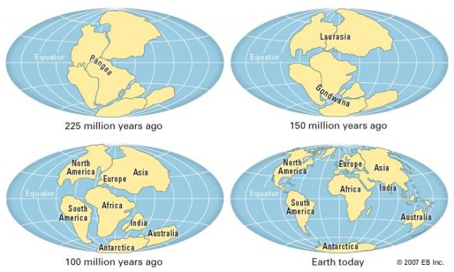
Wegener essentially proposed that the lighter continents are floating on the denser underlying material. By bringing together a large mass of geological and paleontological data, he postulated that for a large part of geological history there was but a single land mass or continent that covered about one-third of the globe. He called that single continent Pangaea, which late in the Triassic period (245 to 208 million years ago) fragmented, and the parts began to move away from one another. Westward drift of the Americas opened the Atlantic Ocean, and the Indian block drifted across the equator to merge with Asia. One of Wegener's chief arguments was the assertion that eastern North and South America would fit well into the outlines of western Africa and Europe.
In 1937 Alexander L. Du Toit, a South African geologist, modified Wegener's hypothesis by suggesting two primordial continents: Laurasia in the north and Gondwanaland (or Gondwana) in the south. Aside from the congruency of continental shelf margins across the Atlantic, modern proponents of continental drift have amassed impressive geological and seismological evidence to support their views. Indicators of widespread glaciation from 380 to 250 million years ago are evident in ANTARCTICA, southern South America, southern Africa, INDIA, and AUSTRALIA. If these continents were once united around the south polar region, this glaciation would become explicable as a unified sequence of events in time and space.
Also, fitting the Americas with the continents across the Atlantic brings together similar kinds of rocks and geologic structures. A belt of ancient rocks along the Brazilian coast, for example, matches one in Africa. Moreover, the earliest marine deposits along the Atlantic coastlines of either South America or Africa are Jurassic in age (208 to 144 million years old), suggesting that the ocean did not exist before that time.
In the 1950s, interest in the concept of continental drift increased as knowledge of earth's magnetic field during the geologic past developed from the studies of geophysicists Stanley K. Runcorn, P.M.S. Blackett, and others. Ferromagnetic minerals such as magnetite acquire a permanent magnetization when they crystallize as constituents of igneous rock. The direction of their magnetization is the same as the direction of the earth's magnetic field at the time and place of crystallization.
REMNANT MAGNETISM
Particles of magnetized materials released from their parent igneous rocks by weathering may later realign themselves with the existing magnetic field at the time these particles are incorporated into sedimentary deposit. Studies of the remnant magnetism in suitable rocks of different ages from all over the world indicate that the magnetic poles were in different places at different times. The polar wandering curves are different for the various continents, but in important instances such differences are reconciled on the assumption that continents now separated were formally joined. The curves for Europe and North America, for example, are reconciled by the assumption that the latter has drifted about 30 degrees westward relative to Europe since the Triassic period.
Increased knowledge about the configuration of the ocean floor and the subsequent formulation of the concepts of seafloor spreading and the theory of PLATE TECTONICS provide further support for the theory of continental drift. During the early 1960s, the American geophysicist Harry H. Hess proposed that new oceanic crest is continually generated by igneous activity at the crests of mid-ocean ridges, submarine mountains that flow a sinuous course of about 37,000 mi (60,000 km) along the bottom of the major ocean basins. Molten rock material from the earth's mantle rises upward to the crests, cools, and is later pushed aside by new intrusions. The ocean floor is thus pushed at right angles and in opposite directions away from the crest. By the late 1960s, several American investigators, among them Jack E. Oliver and Bryan L. Isacks, had integrated this notion of seafloor spreading with that of drifting continents and formulated the basis for plate tectonic theory. According to the later hypothesis, the earth's surface, or lithosphere, is composed of a number of large, rigid plates that float on a soft (presumably partially molten) layer of the mantle known as the asthenosphere. The margins of the plates are defined by narrow bands in which 80 percent of the world's earthquakes and volcanoes occur. There are three types of boundaries.
The first of these is a very narrow band of shallow earthquakes caused by tensile stresses that follow exactly the crest of the 49,000-mi- (80,000-km-) long, active midocean ridges. The second boundary type occurs in areas where these ridges are offset. Earthquakes are much more violent along fault lines at such sites and results from the plates on either side of the faults grinding literally past one another in opposite directions.
Earthquakes forming the third boundary are distributed more diffusely but include all the world's deep earthquakes, that is, those originating at depths greater than 90 mi (145 km) and are associated with extremely narrow zones where the ocean floor descends below its normal depth to as much as 6.5 mi (10.5 km) below sea level—oceanic trenches. Across this margin, the maximum earthquake depths systematically increase along a dipping plane, with shallower earthquakes associated principally with the volcanic activity that borders each trench.
The ridge-crest earthquakes originate because of the tension created when the plates on either side move in opposite directions. This movement also releases the pressure on the underlying hot rocks, causing them to begin melting. The resulting magmas rise to form volcanoes (such as those in ICELAND), which then solidify and later fracture as the tensional forces reassert themselves. Such new volcanic rocks thus become added to the edge of each plate, which grows at these “constructive” margins.
The evidence for plate motion is not only the nature of the earthquakes but also the age of the volcanic oceanic rocks. Dating can be achieved by using both the fossil contents of the sediments overlying the volcanic rocks and the time record represented by the anomalies in the magnetism of the rocks, which can be detected by ships sailing on the ocean surface. These show that the youngest volcanic rocks are at the crest of the midocean ridges and the oldest are in the deepest areas, that is, the oceanic trenches. Nowhere, however, are such rocks older than 190 million years, indicating that all older oceanic rocks must have been destroyed.
The midocean ridges occur along some of the plate margins. Where this is the case, the lithospheric plates separate and the upwelling mantle material forms new ocean floor along the trailing edges. As the plates move away from the flanks of the ridges, they carry the continents with them. On the basis of all these factors, it may be assumed that the Americas were joined with Europe and Africa until approximately 190 million years ago, when a rift split them apart along what is now the crest of the mid-Atlantic Ridge. Subsequent plate movements averaging .8 in or 2 cm per year have brought the continents to their present position.
Although the lateral extent of the plates is well defined, their thickness is less certain. At the crest of the oceanic ridge they are very thin, but heat-flow and seismic evidence suggest that the basin increases rapidly with depth, reaching 30 to 36 mi (48 to 57 km) within about 6 to 12 mi (9 to 19 km) of the crest. By about 597 mi (960 km) distance from the crest, the basin has increased to 71 mi (115 km). A plate may be subducted at any thickness but rarely exceeds 90 mi (145 km). Moreover, the presence of volcanic rocks indicates that here the Earth's lithosphere is at least 118 mi (190 km) thick, so that mantle flow, which causes plate motions, must occur at even greater depths. It seems likely, though still unproven, that the breakup of a single landmass and the drifting of its fragments is merely the latest in a series of similar occurrences throughout geologic time.