plate tectonics
PLATE TECTONICS IS A geological theory that explains many important features of the Earth's surface through the movement of sections of the crust, known as plates. Among the observed data explained by plate tectonics are the known similarities of features on the east and west sides of the ATLANTIC OCEAN, similarities of plant and animal species in areas now too distant for migrations, the locations of volcanoes and earthquakes, the formation of mountain ranges, and the existence of the MID-ATLANTIC RIDGE.
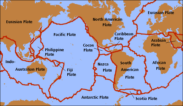
According to plate tectonic theory, the Earth's crust is made up of approximately 30 rigid sections or plates of various sizes. For instance, the PACIFIC OCEAN is mostly one huge plate, and the major continents each lie on their own plates. Very small plates such as the Gorda Plate in the Pacific Northwest are believed to be the last remnants of ancient plates.
Plates lay over a stratum of hot, elastic rock known as the mantle. Temperatures in the mantle range from 2,400 to 2,600 degrees F (1,300 to 2,000 degrees C), and currents within the mantle drive a slow movement of the plates, at the rate of about 4 in (10 cm) per year. Although this movement is small in human terms, observable only with sophisticated scientific measurements, over millions of years plates can move great distances, even from one pole to the other.
PANGAEA
According to plate tectonic theory, about 200 million years ago all present-day continents were part of a supercontinent known as Pangaea or Pangea (Greek for “all-Earth”). Over millions of years, this supercontinent broke up through the creation of rifts, cracks in the crust that moved apart and allowed magma to rise from lower levels and form new seabed. Water moved into the broken landmass to form enclosed bodies of water such as the Gulf of Mexico and the RED SEA. A sufficiently large rift even formed the present-day Atlantic Ocean.
However, since the Earth has not been growing larger, this expansion must cause collisions between plates elsewhere. One of the colliding plates is driven under the other, forming a deep subocean trench beside the resulting subduction zone. The other plate is crumpled and forced upward, forming tall mountains. The HIMALAYAS, the ALPS, and the CAUCASUS all have been formed by these geological processes, and in the Himalayas the process will probably continue for the next several million years. Subduction zones form the world's most powerful earthquakes, often near the top of the Richter scale. Seismologists have theorized that deep-focus subduction zone quakes represent the most energy the Earth's crust is capable of releasing. Subduction zones are also responsible for many of the world's volcanoes, particularly the RING OF FIRE that circles the PACIFIC OCEAN and includes the Cascades and Fujiyama.
There are also transform boundaries, at which plates slide against each other. If the two plates become stuck, energy builds up until it releases catastrophically in an earthquake. One of the best-known examples of a transform boundary is the San Andreas Fault in California. Land on the western side of the San Andreas actually belongs to the Pacific Plate, which is slowly sliding north in relation to the North American Plate, but in an irregular way punctuated by destructive earthquakes such as the 1905 San Francisco quake, the 1989 Loma Prieta quake, and the 1994 Northridge quake.
Even volcanoes and earthquakes within plates have been shown to support the theory of plate tectonics. Volcanoes within a plate are created where a rising current known as a mantle plume burns a hot spot in the crust. As the plate moves, it generates a series of volcanic islands, with the older ones eroding away as they are no longer replenished by eruption. The Hawaiian Islands are an example of this process. The big island of Hawaii is still growing as a result of its active volcanoes, while older islands have only extinct volcanoes, such as Punchbowl Crater on Oahu. The westernmost islands, such as Midway Island, have been reduced to tiny spits of land, while the chain continues westward in a series of seamounts that no longer break the surface. Earthquakes within a plate, such as the famous 1811–12 New Madrid quakes, are caused by compressional stresses of plate movement building up within the plate. Such earthquakes can be very destructive because the central part of the plate transmits seismic energy far more efficiently than the broken crust near a plate boundary.
Some geologists have even gone beyond Pangaea to reconstruct the protocontinents that existed before it. Some theories have gone back as far as the Cambrian era, 600 million years ago. In doing so, they are able to explain the existence of such ancient mountains as the Urals and the Ozarks which now lie firmly embedded in the heart of a continental plate. Those mountains are the last bits of evidence of ancient plates otherwise consumed by subduction. The theory of continental drift was originally proposed in 1912 by Alfred Wegener, a German scientist, but he thought in terms of the continents plowing through the seas like ships.
Although he was ridiculed, studies of sea-floor sedimentation in the 1930s and 1940s suggested that the Atlantic was a relatively young ocean, compared to the age of the Earth. Studies of paleomagnetism, in which the magnetic particles in igneous rock reveal the alignment of the Earth's magnetic field at the location where the rock originally solidified, enabled geologists to reconstruct past land movement across millions of years. The 1969 study of the Mid-Atlantic Ridge by the Glomar Challenger led to general acceptance of the theory of plate tectonics.