How Did Geographers Help in the 2010 Gulf of Mexico Oil-Spill Cleanup?
ON APRIL 20, 2010, an explosion on the Deepwater Horizon oil rig in the northern Gulf of Mexico killed 11 workers, injured 17 others, and initiated the most disastrous oil spill in U.S. history. For the next 86 days, oil gushed into the Gulf. This oil spill is an example of a complex problem with interconnected environmental, economic, and social implications. The geographic approach is ideally suited to solving such problems. The oil spill provides a way to connect the various approaches and tools discussed in this chapter and apply these tools to an important and well-known, real-world example.
Where Was the Oil from the Spill?
The question above seems straightforward, but a major controversy emerged during the summer of 2010 when scientists couldn't identify where the oil from the oil spill had traveled. The spatial perspective of geographers was indispensable in resolving this problem, and their work was in high demand.
Satellite imagery was one of the most effective tools in monitoring the location and movement of oil. This image shows the Gulf waters off Louisiana, with an oil slick visible in the center of the image. The satellite imagery was essential in locating and tracking the oil slick and documenting how the oil interacted with ocean currents and was dispersed in the Gulf.
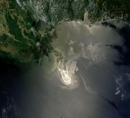
Geographers converted satellite images into visualizations and incorporated these images into GIS databases, where the location and movement of oil could easily be conveyed to cleanup crews and to those concerned with the oil's impact on marine life. This knowledge was also useful in determining the impact of potential storm systems, including tropical storms.
How Did the Oil Travel?
Geographers wanted to know how the oil traveled from the spill site to the coastal area to better understand what to expect if the spill continued and to also explore the impact of ocean currents, waves, and wind on dispersal patterns.
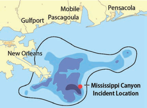
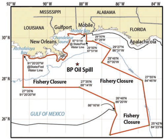
Physical geographers worked with other natural scientists to understand oceanic and atmospheric circulation patterns that influenced the speed and direction of oil migration, which guided decisions about which areas of the Gulf should be closed to fishing.
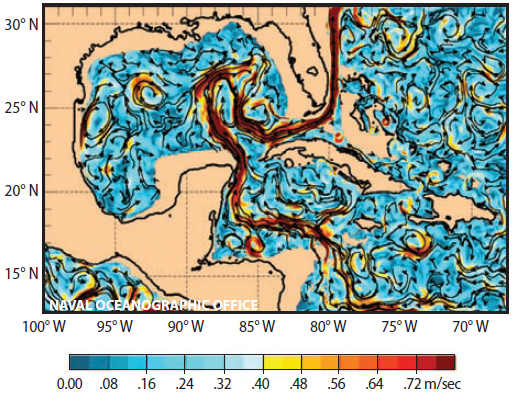
An understanding of the circulation patterns within and near the Gulf, including changes due to hurricanes and other strong storms, improved the ability to forecast the movement of the oil. In this map, red colors indicate faster currents.
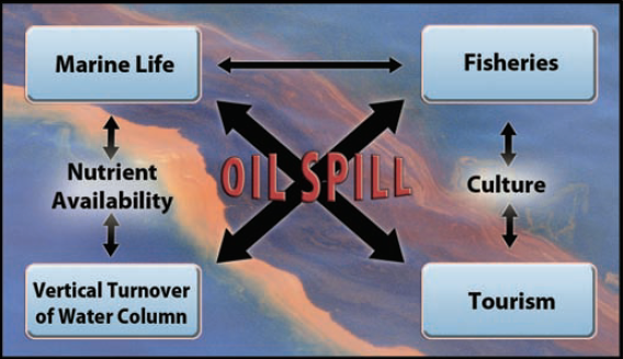
What Is the Effect of the Oil on the Earth-Ocean-Atmosphere-Human System?
The geographer's holistic perspective was needed to understand the “big picture” of impacts of the spill on the various “spheres,” including the human realm. Examine this hypothetical place, and think about all the aspects that could affect the distribution and dispersal of an oil spill, or be affected by the oil. Think about how the oil could relate to interactions among the natural spheres and to social systems of people who might live and work here. After you have thought about these issues, read the text around the figure, which describes a few of the impacts.
Oil reduces evaporation from the surface of the ocean and also reduces sunlight penetration into the Gulf, altering the local energy and water budgets. This could affect amounts and patterns of precipitation and runoff toward the sea.
Winds could bring volatilized oil (oil dispersed as vapors in the air) onto the land, depending on the directions of the concentrated, such fumes would be unpleasant and unhealthy.
Winds and waves can lift oil onto the beach and coastal wetlands, where it can be harmful to the many species of birds, fish, and other animals that dwell there. A GIS database of animal densities could identify the most vulnerable, high-impact sites.
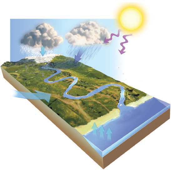
Sunlight can solidify oil, causing it to float as a “tarball” or sink to the seafloor. Some 25% of the oil in the 2010 spill is unaccounted for, presumably because it solidified, sank, and became part of the seafloor. The long-term impact is unknown, but likely harmful.
Oil harms many plants, fish, and other animals that ingest it directly. When these organisms are eaten, the predator ingests the oil, too. Fortunately, most oil is concentrated in parts of the animal that are not usually eaten by humans (shells, organs, etc.). Oil also allows types of bacteria that feed on it to proliferate at the expense of other forms of life, altering the food chain, and releasing gases to the atmosphere. Oil reduces evaporation from the surface of the ocean and also reduces sunlight penetration
into the Gulf, altering the local energy and water budgets. This could affect amounts and patterns of precipitation and runoff toward the sea.
Sunlight can solidify oil, causing it to float as a “tarball” or sink to the seafloor. Some 25% of the oil in the 2010 spill is unaccounted for, presumably because it solidified, sank, and became part of the seafloor. The long-term impact is unknown, but likely harmful. Winds could bring volatilized oil (oil dispersed as vapors in the air) onto the land, depending on the directions of the concentrated, such fumes would be unpleasant and unhealthy.
Winds and waves can lift oil onto the beach and coastal wetlands, where it can be harmful to the many species of birds, fish, and other animals that dwell there. A GIS database of animal densities could identify the most vulnerable, high-impact sites.
Ocean currents can disperse the oil and move it out of the immediate area, so we would want to understand the directions and rates of ocean currents interacting with the oil spill. Such maps would help us anticipate problems downcurrent.
Applying the Geographic Perspective to Disaster Mitigation
Following any disaster, controversies arise, people try to understand what went wrong, and policies are considered to prevent future disasters. Decisions should only be made after understanding the connection between the physical and human systems involved. Over 30 years ago, geographer Werner Terjung described an ideal level of geographic problem solving, which he termed “physicalhuman-process-response systems,” of the kind shown by the figure here. He meant that we need to understand the process involved in both natural and social systems, including our reaction to those processes, which can change our behaviors toward influencing future processes within the natural system, within the social system, and across the two systems.
Was the spill the result of inappropriate regulations, unenforced regulations, or poor decision making? Should dispersants have been used on the oil, or should it have only been collected with skimmers? Should a moratorium on future oil drilling in the Gulf have been implemented? How would such a moratorium affect our future energy supply and the economy of the region? What would be the impact on such a decision locally, regionally, nationally, and internationally?
Terjung also noted that those processes and the responses to them occur at a range of scales that themselves interact and impact the processes occurring at other scales, from millimeters to the global scale! Terjung also noted that no single study had yet accomplished this level of detail. However, he correctly observed that the day would come when we would need to consider problems with impacts in diverse topical and spatial scales, like an oil spill near a sensitive ecology and a densely populated coastline.