What Is the Role of Time in Geography?
WE LIVE ON A GLOBE THAT ROTATES, causing locations on the surface to pass from day to night and back again. Not everyone witnesses sunrise at the same time, because the Sun rises at different times in different locations. Some ideas from geography, especially the concept of longitude, help us understand these differences and describe time so that society can operate in a more orderly manner. Most of us think of time as the hours, minutes, and seconds on a clock, but much longer units of time are used when considering Earth's long history.
How Do We Define Time Globally?
Some units of time, like a year or length of day, arise from natural progressions of the Earth as it orbits around the Sun in a year and completes a full daily rotation in 24 hours. Other measurements of time are locally based, so in the 1800s the world had to agree on an international system for defining time, based on the Prime Meridian and the International Date Line.
Prime Meridian is defined as the 0° longitude measurement on the Earth, passing through the British Royal Observatory in Greenwich, U.K. This location was also chosen as the reference point for world time, a time called Greenwich Mean Time (GMT) or Coordinated Universal Time (UTC). Time anywhere in the world is referenced relative to time at Greenwich.
The globe shown here has meridians spaced equally apart, so that there are 24 zones centered on the lines, one for each of the 24 hours in a day. If you could instantaneously travel from one meridian to the next, there would be a one-hour time difference. If political and other considerations did not intervene, the distribution of time zones could precisely follow lines of longitude, each 15° apart.
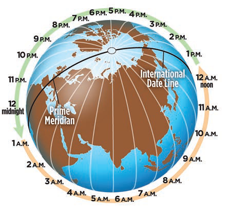
The International Date Line (IDL) is defined as the 180? measurement of longitude in the Pacific Ocean — the meridian on the exact opposite side of the Earth from Greenwich. Segments of the IDL have been shifted east and west to accommodate the needs of some nations in the Pacific, so that travel and trade among those islands is less problematic.
If you cross the International Date Line, you cross into a different calendar day. Traveling westward across the IDL puts you one day ahead of the date (or day) relative to immediately east of the IDL; this is described as “gaining a day.” Moving eastward across the line you move to one day earlier, so we say you “lose a day.”
How Are Time Zones Defined?
The world is divided into 24 time zones, based loosely on longitude. This map color-codes these 24 time zones, most of which have irregular boundaries because they follow natural or political boundaries or try to keep some population center in a single zone. The boundaries between the four time zones covering the contiguous U.S. are mostly drawn along state or county boundaries or natural features.
For most latitudes of the Earth, the Sun shines on all 360° of longitude sometime during the course of a 24-hour day, covering 15° of longitude of new territory each hour. The Earth is divided into 24 time zones, each about 15° of longitude wide. Areas within a time zone adopt the same time, and there is a one-hour jump from one time zone to the next. If you are in one time zone, the time zone to the west is one hour earlier, and the time zone to the east is one hour later.
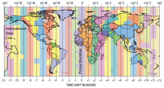
In most of the U.S. and Canada, clocks during the summer are set to one hour later for much of the year. This Daylight Savings Time (DST) provides daylight for an extra hour during the evening and one less hour of daylight in the morning. Some areas, like Saskatchewan and most of Arizona, do not observe DST, remaining instead on “standard time.”
How Do We Refer to Rates of Events and Processes?
Many aspects of physical geography involve the rates of processes, such as how fast a hurricane is moving toward a coastline or how fast water in a river is flowing. We calculate the rates of such processes in a similar way to how we calculate the speed of a car or a runner. Some rates, like wind velocities inside a tornado, are very rapid, whereas other rates, like the uplift of a mountain range, are very slow. For scientific work, units are metric, so we talk about millimeters per year, kilometers per hour, or similar units of distance and time.
Calculating Rates
1. A runner provides a good reminder of how to calculate rates. A rate is how much something changed divided by the time required for the change to occur. Generally, we are referring to how much distance something travels in a given amount of time.

2. If this runner sprinted 40 meters in 5 seconds, the runner's average speed is calculated as follows:
distance/time = 40 m/5 s = 8 m/s
3. What is the runner's average speed if she runs 400 meters in 80 seconds? Go ahead, try it. We don't need to provide you the answer to this one.
Relatively Rapid Earth Processes
4. Some Earth processes are relatively rapid, occurring within seconds, minutes, or days. Relatively rapid natural processes include the velocity of the atmospheric jet stream (100s km/hr), speeds of winds inside a severe storm (100s km/hr), motion of the ground during earthquakes (5 km/s), movement of an earthquake-generated wave (tsunami) across the open ocean (100s km/hr), and the catastrophic advance of an explosive volcanic eruption (100s km/hr).
5. Hurricane Sandy, a huge and incredibly destructive storm that occurred in October 2012, is an example of a rapid natural process. Sandy originated as a tropical storm but migrated up the East Coast of the U.S. until it turned inland and struck New Jersey. While in the tropics, Sandy had winds estimated at 185 km/hr (115 mi/hr), but it had weakened considerably by the time the storm came ashore. The storm killed nearly 300 people along its path and caused damages of over $70 billion, mostly in New Jersey and New York.
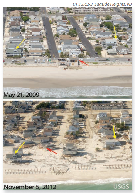
6. The two photographs above show Seaside Heights, N.J., before and after the storm. The yellow and red arrows point to the same houses in both photographs. Although the photographs were taken several years apart, nearly all the damage occurred within a 24-hour period. In this short time, the shape of the coastline was extensively rearranged, houses were destroyed, and the entire neighborhood was covered in a layer of beach sand washed in by the waves.
Relatively Slow Earth Processes
7. Other Earth processes are very slow, occurring over decades, centuries, or millions of years. Natural processes that are fairly slow include movement of groundwater (m/day), motion of continents (cm/yr), and uplift and erosion of the land surface (as fast as mm/yr, but typically much slower). Although these processes are relatively slow, the Earth's history is long (4.55 billion years), so there is abundant time for slow processes to have big results, such as uplift of a high mountain range.
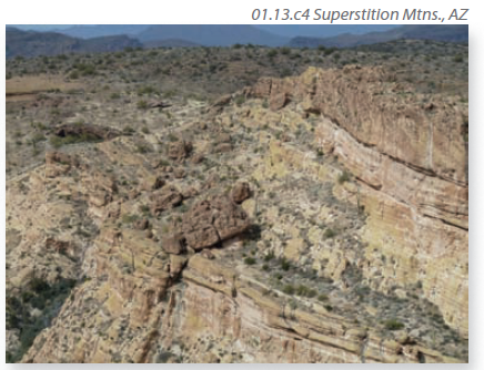
8. Observe this photograph taken along a canyon wall and ask yourself how long each feature took to form. You do not need to arrive at any answers, just the questions. The tan, brown, and yellowish rocks are all volcanic rocks, formed from molten rock and volcanic ash erupted from an ancient volcano.
9. Several questions about the rates of processes come to mind. Each layer in the volcanic rocks may represent a single pulse of eruption and could have accumulated rapidly, in minutes or hours. How long did it take to form all the layers? The landscape currently is being eroded, and this process has been occurring in this area for millions of years. How long will it take for the large brown blocks to fall or slide off the lower cliff? Some of these questions are about the present (how fast is erosion occurring), some are about the past (eruptions), and others are about the future (the blocks). The easiest questions to answer are usually about the present, and the hardest ones are about the past or the future.
- How Do We Use GIS to Explore Spatial Issues?
- How Do We Use Global Positioning Systems and Remote Sensing?
- How Do We Use Maps and Photographs?
- How Do Map Projections Influence the Portrayal of Spatial Data?
- What Are Some Other Coordinate Systems?
- What Do Latitude and Longitude Indicate?
- How Do We Depict Earth’s Surface?
- How Do Earth’s Four Spheres Interact?
- What Are Some Important Earth Cycles?