What Causes Ocean Currents?
SURFACE WATER OF THE OCEANS circulates in huge currents that generally carry warmer water toward the poles and colder water toward the equator. Extremely large quantities of energy are stored in the uppermost 100 meters of the global oceans, and surface ocean currents redistribute this energy from one part of the ocean to another, carrying it from zones of excess energy to those with an energy deficit. What causes ocean currents, and can we make some general predictions about which way ocean currents would likely flow?
What Causes Surface Waters of the Ocean to Move and Which Way Do They Go?
Various processes cause surface water to move, but the primary driving force is wind. Wind blowing across a body of water transfers some of its momentum onto the surface of the water, causing it to move. On a smaller scale, this causes waves and on a global scale, this sets in motion large currents that can traverse an entire ocean.
1. As wind blows across water, it pushes against the surface, causing the uppermost water to begin flowing.
2. This water in turn transfers some of its momentum to waters just below the surface, setting up an overall shearing of the water column, with the strongest shear force (depicted by arrows) at the surface.
3. The effects of wind stress vanish at a depth of about 100 m, a depth known as the null point.
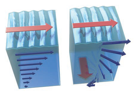
4. If the planet were not rotating, water above the null point would flow parallel to the direction in which the wind is blowing. On Earth, however, as soon as the water starts moving it is subject to the Coriolis effect, and so it has an apparent deflection away from its initial direction, turning to the right in the Northern Hemisphere.
5. As the effects of the shearing force decrease downward, toward the null point, the direction of flow turns farther to the right with depth. In this way, the direction and velocity of flow, when plotted as a series of arrows, define a downward spiraling shape — an Ekman spiral.
6. As a result of these competing influences, the overall direction of flow of the uppermost ocean, when averaged between the surface and the null point, is at an angle to surface winds.
Which Way Do Surface Winds Blow Against the Ocean Surface?
If wind patterns drive the flow of the upper part of the ocean, we should be able to anticipate the directions of ocean currents from considering the directions of wind.
1. This globe reviews the main belts of winds encircling Earth. Examine the globe and consider what pattern of ocean currents might result from these wind directions. Try this before reading on.
2. As you thought about likely directions of currents, you probably realized that eventually any current that flows east or west will at some point run into a continent — the continents are in the way, so an ocean current must turn to avoid the continent.
3. Recall that winds are generally not very strong along the equator, the so-called doldrums. They are also very weak in areas of descending air in the subtropics, at 30° N and 30° S latitude — the horse latitudes.
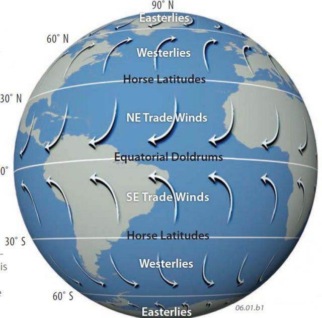
4. Another factor to consider is that the apparent deflection of moving objects by the Coriolis effect is opposite across the equator. The apparent deflection is to the right north of the equator and to the left south of it.
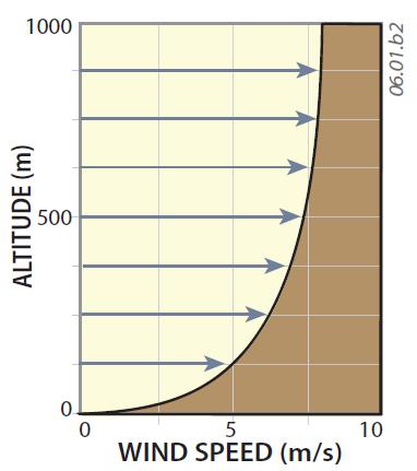
5. This graph shows the general relationship between wind speed and altitude. Winds are slower near the surface, and they increase upward. Winds slow down near the surface because their energy of motion (kinetic energy) is transferred from the wind to the surface, producing waves and currents.
What Is the Anticipated Pattern of Global Surface Ocean Currents?
Given what we know about the global distribution of surface pressure cells and the direction of surface winds, it is reasonable to make a first approximation of the direction of surface ocean currents as a series of interacting circular motions, or gyres, like the ones in the stylized ocean shown below.
1. A key characteristic of this hypothetical planet is that the central ocean extends from pole to pole, so it crosses all of the regional wind belts, from the equatorial doldrums to the polar easterlies. The adjacent continents also nearly extend from pole to pole, effectively confining the ocean on both sides.
2. Surface waters flowing from a lower latitude (closer to the equator) toward a higher latitude (closer to the poles) transport water with greater stored energy than expected at that latitude and are considered “warm” currents. Those flowing in the reverse direction, from higher to lower latitudes, will have less stored energy than expected and are termed “cold” currents. The terms warm and cold should only be considered relative to the environment through which they are passing and are indicative of whether they are bringing energy to or removing it from an environment. Accordingly, warm currents are colored red and cold currents are colored blue. Note that a single gyre brings warm water to the coast of one continent but cold water to the coast of the other continent, as described below.
East Coast of Continent
45° N–60° N: Cold surface waters originating from north polar regions.
25° N–35° N: Warm surface waters originating from equatorial regions and moving northward.
25° S–35° S: Warm surface waters originating from equatorial regions. Note that this happens with winds from the opposite direction from the Northern Hemisphere.
45° S–60° S: Cold surface waters originating from south polar regions. Note that this happens with winds from the opposite direction from the Northern Hemisphere.
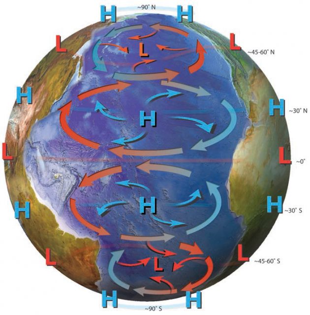
West Coast of Continent
45° N–60° N: Warm surface waters originating from subtropical regions and moving northward.
25° N–35° N: Cold surface waters originating from mid-latitude regions.
Equatorial Latitudes: Mostly warm waters flowing east to west.
25° S–35° S: Cold surface waters originating from mid-latitude regions and flowing north.
45° S–60° S: Warm surface waters originating from subtropical regions.
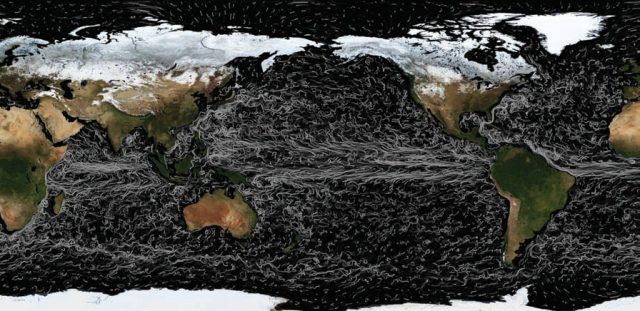
To remind us that generalized models are just that, we include a numeric model of actual ocean currents, whose squiggly lines bring to mind the style of painter Vincent van Gogh.