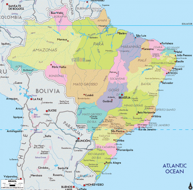
Brazil
Area 3,286,488 square mi (8,511,965 square km)
Population 202.0 million 2014
Capital Brasilia
Highest Point 9,888 ft (3,014 m)
Lowest Point 0 m
GDP $2.346 trillion 2014
Primary Natural Resources bauxite, gold, iron ore, uranium, petroleum.
BRAZIL IS THE LARGEST and most populous country in South America. The country occupies almost half of the continent. Slightly smaller than the UNITED STATES, it is the fifth-largest country in the world. Brazil has become the leading economic power in South America, due to its vast natural resources, a large labor force, and impressive developments in industry and agriculture. At the same time, income distribution in the country is highly unequal.
The ATLANTIC OCEAN borders Brazil to the east. The country shares a border with every country in South America except for CHILE and ECUADOR. A majority of Brazil is tropical, as it is located between 5 degrees north and 33 degrees south latitude. A small percentage of the country is below the TROPIC OF CAPRICORN.
By the end of the 20th century, the population of Brazil had reached about 180 million. The population has grown extremely fast since 1950, with annual growth rates greater than 2.2 percent. Because of the recent and rapid population growth, Brazil possesses a young population, with two-thirds of the people under age 25. The population is unevenly distributed, as it concentrates along the coast. Coastal areas have a population density of about 12 inhabitants per square mile, while in the interior that figure is a mere 2 people per square mile. Brazil is also a highly urbanized country, with two-thirds of the population living in cities. Population growth has been accompanied by significant rural-to-urban migration.
The population of Brazil is a mixture of Native American, European, African, and Asian peoples. Brazil had no large Native American civilizations as in MEXICO or PERU. At the time of the arrival of Europeans in 1500, there were perhaps 1 million indigenous people in Brazil. These native inhabitants can be divided into two main categories: the Tupi-Guarani and the Tapuya. In 1500, the Portuguese became the first Europeans to encounter Brazil, which became a Portuguese colony until 1822. In the 19th and 20th centuries, numerous European immigrants came to Brazil from countries such as PORTUGAL and ITALY. Brazil also possesses a large African population as a result of the slave trade. Brazil received more African slaves than any other New World colony. In 1888, Brazil became the last country in the Western Hemisphere to abolish slavery.
The Guyana Highlands in northern Brazil extend into the neighboring countries of VENEZUELA, GUYANA, SURINAME, and FRENCH GUIANA. The region is rugged and transportation is difficult. Many parts are still very inaccessible, and the Guyana Highlands are one of the world's last natural and cultural preserves. The highest peak in the region is Mount Roraima, which reaches 9,432 ft (2,875 m). While the area is rich in mineral resources, few have been exploited until recently. Some parts of the northern highlands are now heavily mined for gold, diamonds, iron-ore, and bauxite. There are also many rapids and waterfalls in the Guyana Highlands, most of which drain into the AMAZON system.
The Amazon is the dominant river system in Brazil. The river is so large that it is often referred to as the “river-sea” in Portuguese. The Amazon River has a greater volume of water than any river, containing 14 times the volume of the MISSISSIPPI RIVER. The river's width varies from 1.9 to 8.8 mi (3 to 14 km), making it impossible to see from shore to shore at many points. The Amazon begins high in the ANDES mountains in Peru and flows eastward toward the Atlantic Ocean for some 4,000 mi (6,437 km). More than 1,000 tributaries join the river along the way. The Amazon and its tributaries provide more than 25,000 mi (40,233 km) of navigable routes. At 200 mi (322 km) across and 200 ft (61 m) deep, the mouth of the Amazon is so wide that it holds the Ilha de Marajo, an island the size of SWITZERLAND. Ocean-going ships can reach the city of Manaus, located 1,000 mi (1,609 km) inland.
RAINFOREST
The BASIN around the Amazon River is the largest in the world. It drains some 3 million square miles in Brazil alone and covers more than one-third of the country's territory. The Amazon basin is an ecologically diverse region that includes RAINFORESTs and tropical GRASSLANDS. One–third of the world's rainforest is contained in the Amazon region. The Amazon rainforest possesses a great variety of plants and animals. However, exploitation by human beings has threatened the environment in the Amazon. From a 19th-century rubber boom to 20th-century gold rushes, Brazil has often attempted to exploit the region. The resultant increase in human settlement has led to the destruction of much of the Amazon rain forest.
The Brazilian Highlands, also called the Brazilian Plateau, make up the heart of the country, covering more than one-third of Brazil's territory. The Highlands stretch from the south near the borders with URUGUAY and PARAGUAY to the north near the Amazon River. This region of Brazil is mostly old, eroded landscape that averages 2,000 to 3,000 ft (607 to 914 m) in elevation. The Brazilian Highlands are similar geologically to the Guyana Highlands, with many rapids and waterfalls. The most famous waterfall in the region is Iguacu Falls. The Iguacu River consists of miles of rapids, which fall dramatically to join the Parana River. The Brazilian Highlands can be divided into three subregions: the Great Escarpment, a large interior zone of sedimentary rocks, and the Mato Grosso Plateau.
Located along the Atlantic edge of the Brazilian Plateau is the Serra do Mar, or the Great Escarpment, which provides a barrier between the coast and the interior of the country. The Great Escarpment rises abruptly from the Atlantic Coastal Plain to heights up to 9,000 ft (2,743 m). Because of the presence of the Great Escarpment, few rivers flow from the interior to the coast, with the Sao Francisco being the major exception. The escarpment has historically served as an obstacle to human settlement in the interior of Brazil. The Atlantic side of the Great Escarpment receives heavy rainfall. The port city of Santos on the coast receives some 8 in (20 cm) of rain annually. In contrast, Sao Paulo receives only 50 in (127 cm) per year. Rainfall decreases moving westward. The escarpment and the interior to the west have rich mineral deposits. In the 17th century, colonial Brazil enjoyed a gold and diamond boom. By the 20th century, important industrial minerals such as titanium, manganese, chromium, and tungsten were mined.
The large interior region of the Highland consists of sedimentary rocks over the old crystalline base. In the north is the famous sertao, a desolate, eroded backland. Consisting of scrub forests, these backlands receive very irregular rainfall, leading to long droughts and flash floods. In the south is the Parana Plateau, where deposits of volcanic lava created the famous fertile red soil important for the production of coffee and other agricultural products.
Brazilians have long seen the Mato Grosso Plateau as a frontier area of great potential. Brazil acted on this view by building the new national capital of Brasilia there in the 1950s. This new capital in the interior of the country would serve as a symbol of modern Brazil. In later years, the plateau has been opened to mining. Also located in the Brazilian Plateau is the Pontanal, a large wetland drained by tributaries of the Paraguay River. This wetland is home to much biological diversity. However, it is severely threatened by human development.
The Atlantic Ocean has always been important for Brazil. Immigrants, traders, money, and ideas all flowed into the country across the ocean. Brazil's great natural resources flowed out via the Atlantic. The country's population has historically stayed close to the narrow Atlantic Coastal Plain. One 17th-century historian wrote that Brazilians “cling crab-like to the beaches.” The coastal plain possesses a number of excellent bays such as Todos os Santos and Guanabara.
The Atlantic Coastal Plain was once covered with dense forest. Even before the arrival of Europeans in the 1500s, the native Tupi people practiced slash-andburn agriculture that involved clearing much of the forest. The Portuguese continued to destroy much of the forest. Only about 10 percent of the original Atlantic forest remains. The region is home to many rare and endangered species that are found nowhere else in the world.
The plain is widest at the Reconcavo region near the city of Salvador da Bahia. It was here that Portuguese settlers implemented a large-scale system of sugar plantations. Using slaves, the Portuguese made Brazil into the world's leading sugar producer.