Mississippi River
MARK TWAIN begins the novel Life on the Mississippi by writing “The Mississippi is well worth reading about. It is not a commonplace river, but on the contrary is in all ways remarkable.” No better words can be used to summarize of one of the world's largest, and North America's greatest, river.
The Mississippi River is born as little more than a trickle of water from Lake Itasca in the northwoods of MINNESOTA. It takes just nine small steps to cross, and is no more than ankle deep. From this beautiful but unimpressive brooklet grows the monstrous stream that drains the heart of a continent. The name Mississippi comes from the Chippewa (Ojibwa) word Misipi, which translates to “big water” or “great river.” From Lake Itasca, derived from Latin meaning “the true head,” the Mississippi River travels about 2,300 mi (3,705 km) to the Gulf of Mexico. Because the river's course is constantly changing, its exact length is hard to accurately know. Different sources will inevitably offer many different numbers.
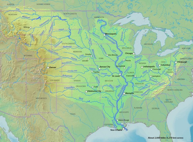
The length has been stated as long as 2,552 mi (4,107 km). When combined with the Missouri River, the longest tributary of the Mississippi, the river system is the fourth longest in the world, behind only the NILE, AMAZON, and CHANGJIANG (YANGZI) rivers. Along the route, the river falls 1,475 ft (450 m), nearly half of which is lost before the river reaches Minneapolis, Minnesota.
Depth also varies along the river. The U.S. Army Corps of Engineers keeps a navigation channel of at least 9 ft (3 m) to the end of navigable water at Minneapolis for cargo vessels. However, the river is much deeper than that in its lower reaches. Near New Orleans, LOUISIANA, the river is not as wide as it is farther upstream but carries more water. This is possible because of the increased depth there. Off Algiers Point in New Orleans, the river reaches 200 ft (61 m) in depth.
Water volume increases steadily as the river flows south. In the upper reaches, tributaries like the Minnesota, Chippewa, and Wisconsin rivers join. The largest jump in volume occurs in the middle reaches, where the two largest tributaries, the Missouri and Ohio rivers, combine with the Mississippi. In the lower reaches, the Mississippi gets a boost from rivers like the Arkansas, Yazoo, and Red. The Mississippi River ranks fifth in the world in average discharge.
The Missouri and Ohio rivers add the most volume, and contribute to flooding more than any other tributaries. The Missouri River drains an enormous area. Its coverage stretches from southern CANADA to the middle of KANSAS, and as far west as IDAHO. Its major tributaries include the Yellowstone, Platte, and Kansas rivers. The Ohio is also impressive; though not as long as the Missouri, its drainage receives more annual precipitation. Its major tributaries are the Allegheny, Kanawha, Cumberland, and Tennessee rivers.
Water from Lake Itasca will travel through or along 10 U.S. states, reaching the Gulf of Mexico in about 90 days. The average speed of the river near the headwaters is around 1.2 mi (1.9 km) per hour. In the lower reaches the speed can exceed 3 mi per hour (4.8 km per hour). It could be said that the river travels about as fast a person walks.
MISSISSIPPI WATERSHED
The watershed of the Mississippi River is the second largest in the world. It drains an area of over 1.25 million square mi (4.76 million square km). The watershed reaches from the Allegheny Mountains in the east to the ROCKY MOUNTAINS in the west. This area makes up 41 percent of the United States, including all or some of 31 states and two Canadian provinces, Manitoba and Saskatchewan. The river drains one-eighth of North America.
Europeans did not discover the Mississippi River until 1541. In that year, Hernando De Soto came upon the river south of present-day Memphis, TENNESSEE. He arrived there after traveling overland from the Gulf Coast of FLORIDA in search of El Dorado and the Seven Golden Cities of Cibola. De Soto died of fever within a year of the discovery and was buried in the river. Interest in the Mississippi River by Europeans would not rise again for over 100 years. Upon hearing rumors of a great river, and in need of water routes, the French sent two men from the Great Lakes to explore the river in 1673, Louis Jolliet and Jacques Marquette. The men found the river and traveled on it south as far as the confluence of the Arkansas River. Sieur de La Salle later claimed the river for FRANCE in 1682.
Development along the river was slow to come after its discovery. Natchez (in present-day Mississippi) was founded in 1716, and was closely followed by New Orleans, Louisiana, in 1718. The LOUISIANA PURCHASE occurred in 1803, opening western lands and bringing settlers to the river. Fertile agricultural lands and the discovery of minerals such as lead attracted many. The steamship was invented in 1807, making upstream travel feasible, and commerce increased rapidly. Today, nearly 300 million tons (272 billion kg) are shipped on the river annually.
In 1861, the river gained strategic importance. As the Civil War began, the Mississippi was vital to the Union's war plan. If the river could be controlled, the Confederacy would be split in two. Thomas Jefferson once said, “He who possesses the Mississippi possesses power.” The Union also thought so, and General Ulysses S. Grant captured Vicksburg, Mississippi, on July 4, 1863, opening the river and taking a large step toward Union victory.
MISSISSIPPI FLOODS
There are still a few battles being fought on the Mississippi River. One is being fought by the U.S. Army Corps of Engineers against the river itself. Large floods are very destructive to agriculture, property, and human life. The first levee built to hold back floodwaters was constructed in 1717. It was 3 ft (1 m) high and stretched just over 1 mi (1.6 km) to protect New Orleans. The Mississippi River Commission (MRC) was created in 1879 to improve the river for navigation and to control flooding. Engineer James B. Eads designed and constructed jetties at the river's mouth to make the Mississippi deepen its own channel. The levee system was expanded and its height increased. In 1882, the Mississippi flexed its muscle and spilled over the levees and compromised them in 284 places, proving their ineffectiveness. The MRC decided the system needed rapid expansion after a similar flood in 1890.
Flooding continued after expansion. Floods occurred in 1897, 1903, 1912, 1913, 1922, and in 1927 the largest flood to date created 226 levee breaks and inundated an estimated 11 million acres (4.4 million hectares); 246 people died and damages may have been as high as $400 million. It was decided again to increase the size of the levees and create floodways to funnel water. Floods followed in 1937, 1973, and the most destructive Mississippi flood occurred in 1993. Levees have been shown to increase the magnitude of flooding while decreasing their frequency.
Today, locks and dams have been constructed between St. Louis and Minneapolis to aid navigation, 29 in all. In 1963, the Old River structure was completed in Louisiana to keep the Atchafalaya River from capturing the Mississippi and rerouting it away from New Orleans. The Atchafalaya Basin offers a steep, short route to the Gulf of Mexico, which the Mississippi will take if allowed. Flood control is being reevaluated and the river is being allowed to reclaim some of its floodplain to reduce the extent of flooding. Flood control measures have come under heavy fire from the public because of continued flooding, and by environmental lobbies because of the presence of endangered species and the interruption of natural systems.