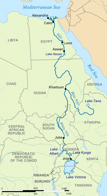
Nile River
AT 4,132 mi (6,650 km) long, the Nile River is the longest river in the world. It flows from two principal sources in equatorial Africa that join at KHARTOUM, SUDAN, and continues north through Sudan and EGYPT, emptying into the MEDITERRANEAN SEA. Historically, the Nile has been used in irrigation, farming, and transportation for thousands of years, from the beginning of Egyptian civilization into the 21st century.
The Nile is fed by many tributaries, but ultimately it has two main sources: the White Nile in BURUNDI, and the Blue Nile in ETHIOPIA. Except when swollen by rains in August and September, the Blue Nile contributes less than 20 percent of the water; the White Nile provides the larger share. The ultimate source of the White Nile remained a tantalizing mystery until 1937, when Burkhart Waldecker discovered it while seeking asylum in the Belgian Congo from Nazi persecution in his native GERMANY. Waldecker pinpointed a stream that became the Kasumo River, flowing from Mount Kikizi in Burundi. This river eventually joins the Mukesenyi, the Ruvyironza, the Ruvubu and finally the Nyabarongo River. Also vying for recognition as the source is another small stream from Mount Bigugu that feeds into the Lukarara River and then joins the Nyabarongo.
WHITE NILE
After the Nyabarongo and Ruvubu rivers join to form the Kagera River, the waters, which will become the White Nile, flow east over Rusumu Falls and then into Lake VICTORIA. The river, now called the Victoria Nile, leaves the lake in the north, dropping over Owens Falls Dam into Lake Kyoga. The river then flows east into the Great African Rift Valley by cascading over Kabarega Falls to Lake Albert. It leaves the lake as the Albert Nile, going north through UGANDA. At the border with Ethiopia the river's name changes again, to Bahr al-Jabal, Mountain River. The Mountain River cascades through highlands before reaching the Sudd, a swampland that brings the waters to a halt, where half the river is lost to evaporation. The marshes and lagoons of the Sudd have existed for millions of years, although the expanse of the Sudd varies depending on seasonal rains and the outflow from the lakes and rivers that feed into it.
After hundreds of miles, the Nile waters emerge from the reservoir of Lake No in the north as the White Nile and join with the Sobat River near Malakal in Sudan. Here it finally takes on the color that gives it its name, and 500 mi (805 km) later it joins with the Blue Nile. Just 30 mi (48 km) south of Khartoum, the White Nile is dammed into a reservoir by the Jabal Auliya Dam. The original purpose of this dam was to hold back the White Nile during the late summer and fall months when the Blue Nile swelled with rain.
Waldecker's 1937 discovery of the White Nile's source resolved thousands of years of mystery. Greek historian Herodotus had speculated about the Nile's origin in 460 B.C.E. Roman Emperor Nero sought the source during his reign, but the centurions he sent to explore were stopped by the Sudd. Until 1841, the Sudd blocked all attempts to trace the Nile, but in that year an Egyptian expedition did pass through the swampland. Over the next century, many explorers failed and some died attempting to trace the Nile.
BLUE NILE
The Blue Nile's source is a stream issuing from Mount Gish in Ethiopia called Sakala. The stream is considered sacred and develops into a river named Little Abbai. This feeds into the southern end of Lake Tana, and Great Abbai, the Blue Nile, flows south out of this lake to drop 150 ft (46 m) from a naturally occurring lava dam and form the Tisisat Falls (the name means “Smoking Waters”). From this point, the Blue Nile makes a wide semicircle and turns east, then north through Sudan. Many rivers feed into it: the Didessa, Dabus, Beles, Dinder, and Rahad among them; some of the rivers contribute water seasonally.
The Blue Nile swells in late summer from heavy rainfall. Dammed in several places, the Blue Nile provides irrigation for the Gezira Plain in Sudan. After leaving Lake Tana, the Blue Nile meets the White Nile at Khartoum, at a place called the Mogren, meaning “the meeting” in Arabic. James Bruce of Scotland found the source of the Blue Nile in 1770 and was appointed governor of Sakala by Ethiopian Emperor Tekla Haymanot II. The Ethiopians had long been aware that their sacred spring was the source of the Blue Nile; a visiting Spanish priest wrote about being shown the source of the Nile in 1615. Bruce was not believed in Europe when he announced his discovery, but his published works detailing his journey were verified by later explorers.
From Khartoum, the Nile flows north. Six sections of rapids, called cataracts, mark it; the first is at Sabaluqa, 50 mi (80 km) from Khartoum. The northernmost, or first, cataract is at Aswan.
The Atbara River, another major tributary of the Nile, joins the river between the fifth and sixth cataracts. Like most of the other waters contributing to the Nile, the Atbara comes from Ethiopia, where summer monsoonal rains cause the waters to peak in August in September; the waters drop to lower levels from December through April. Coming from the tablelands, the waters that join the Nile carry rich alluvial sediments that for 8,000 years flooded into the farmlands along the banks of the Nile. The original name for Egypt, in fact, was Kemet, the same word used to describe the black silt deposited by the Nile.
ASWAN DAM
The Nile Waters Agreement of 1959 was negotiated between Egypt and Sudan; Ethiopia, RWANDA, and Burundi were excluded. This agreement divided riparian rights to the Nile between the two negotiating countries, and cleared the way for the building of a new Aswan Dam. From 1959 through 1970, the Soviet
Union financed the construction of the hydroelectric Aswan High Dam. To provide power for the construction, the old Aswan Dam was electrified and equipped with turbines to generate up to 1.8 million kilowatts. By the time it officially opened in 1971, the dam had formed Lake Nasser, which is called Lake Nubia in Sudan. The lake, a reservoir holding up to 162 billion cubic meters of Nile water, is 8 mi (13 km) in width and over 300 mi (483 km) long.
The Aswan High Dam controls the annual flooding of the Nile and supplies electricity for Egypt, but it has created problems as well. The new reservoir displaced 50,000 Nubians initially. Its weight creates instability on local fault lines in the Earth. The dam traps sediments that would be delivered to farmlands in Egypt, and silt that would replenish the Nile Delta, which is now eroding. Trapped behind the dam, the sediments produce algae that destroys oxygen in the lake.
The Nile provides waters to over 250 million people; that figure may double by 2025. While the population of countries fed by the Nile grows by about 3 percent a year, the waters do not increase. Evaporation from Lake Nasser claims 10 billion cubic meters of water yearly, roughly 9 percent of the average annual flow of the Nile into Aswan.
Another major and controversial flood control project on the Nile, the Jonglei Canal in Sudan, was begun in 1978 to circumvent the Sudd marshes. This idea had first been proposed by William Garstin, a British hydrologist, in the early 1900s. Construction stopped in 1983 due to civil war and has never been completed.