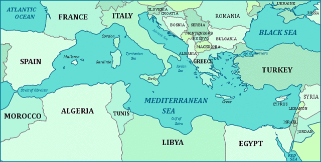
Mediterranean Sea
THE TRANSLATION of its Latin name (“in the midst of land”) indicates that the Mediterranean Sea is located between the landmasses of Europe, Asia, and Africa. Some students of geography may view the Mediterranean as a physical separation between Europe and Africa. Nothing could be further from the truth. The Mediterranean, in fact, has been the great unifier and link for cultures from Africa, the MIDDLE SAST, and Europe as well as Central Asia (via the BLACK SEA passage). Its moderate climate and rich land and sea resources have made the Mediterranean Basin and Sea an historic storehouse of foods as well as a means of commerce. Perhaps a better image is one of a giant mixing bowl that collects and spins out various cultures and economies. Even geologically, the Mediterranean Sea is where the African and European plates meet, their friction creating the rich marble quarries and volcanoes that mark much of ITALY and the Sea of Marmara (marble) in TURKEY.
The sea's total surface area is 967,000 square mi (2.5 million square km). Acting as a major heatsink, it is an important climate modifier (its latitude is the same as that of the much colder areas of Manchuria and north CHINA). It is approximately 2,400 mi (3,900 km) long, with a maximum width of 1,000 mi (1,600 km), and while relatively shallow at GIBRALTAR and the Dardanelles, it is over 16,000 ft (5,400 m) deep near Cape Matapan, GREECE. Its waters have a higher salinity than the ATLANTIC OCEAN in part because there is so little tidal movement. It also has very few rivers that add fresh water, and its high sunshine creates massive rates and volumes of evaporation. Its rich marine resources include over 400 varieties of fish, along with sponges and corals and recently, oil and natural gas also have been found in several sections. Combined with large and often poor populations, there is much overfishing and pollution. But its mild climate has also created rich agricultural resources, and its geology has added important minerals—especially tin and copper so important to the Bronze Age.
Because of its size and complexity, the Mediterranean can be considered a combination of basins or “seas,” and not as a monolithic whole. For example, in addition to the shallow sills at Gibraltar and the Dardanelles, there is a shallow sill (the Adventure Bank) between Sicily and TUNISIA that clearly divides the Mediterranean into two primary basins: east and west. In addition, history and geography have created a number of distinct local “seas” essential to understanding the basin's history. These include the Ligurian Sea north of Corsica; the Tyrrhenian Sea enclosed by Sardinia, Italy, and Sicily; the ADRIATIC, which separates Italy and the Dalmatian coast of the former Yugoslavia, the Ionian Sea between Italy and Greece, the AEGEAN between Greece and TURKEY, and the Thracian Sea to the north. And this omits the various seas associated with the Black Sea.
Today, the Mediterranean forms a maritime link for 23 countries (more if we count the countries that share the coast of the Black Sea), including: SPAIN, FRANCE, MONACO, Italy, MOROCCO, ALGERIA, TUNISIA, LIBYA, EGYPT, SLOVENIA, CROATIA, BOSNIA AND HERZEGOVINA, ALBANIA, Greece, Turkey, MALTA, CYPRUS, SYRIA, LEBANON, and ISRAEL. It provides for maritime passage from the heart of RUSSIA and Central Asia via the Black Sea, to the New World via the ATLANTIC OCEAN, and to the INDIAN OCEAN and Pacific Far East via the Suez Canal. Its rivers create land links that tie it to northern Europe as well as to eastern Africa and the Indian Ocean.
The populations with direct access to its shores exceed 425 million (650 million including countries bordering the Black Sea). This makes the Mediterranean Basin potentially one of the world's major economic zones. It also makes it a focus for political intrigue from Asia and the Middle East to northern and eastern Europe.
In addition to its rich resources and history, it is the sea's strategic geopolitical characteristics—past, present, future—that have dominated its existence. The strategic maritime CHOKE POINTs and history of GIBRALTAR, MALTA, Taormina, and the Dardenelles and Bosporus provide countless examples of the geography behind history.
And the mixing of cultures also has made the Mediterranean Basin a historic center for unique and rich art traditions, from the ancient cave paintings of France and Spain, to the work of modern artists like Marc Chagall, Pablo Picasso, and Paul Cezanne to the mosaics and unique architecture of the Byzantines and Italians. There are naval arts and maps associated with the rise of maritime powers such as the Ottomans, the Venetians, the Genovese, the Spanish, and more.
The LITTORAL (coast) of the Mediterranean was the focus of the Phoenician, Greek, Minoan, Egyptian, Syrian, Macedonian, Roman, Venetian, Genoan and other city-states, empires, and civilizations. Trade, navies, and armies moved over its surface and along the passes to and from its shores.
The shallow and narrow passage linking the Mediterranean to the Atlantic at Gibraltar is only 8 mi (12.9 km) wide, but strong winds and extremely strong tidal flows and currents often forced ancient people to find land routes around the barrier. Similarly, the strong currents over the shallow and narrow sill linking the Mediterranean and Black Seas at the Dardanelles (1 mi or 1.6 km wide) long halted direct shipping between the two basins and was the focus of such epic battles as that of Troy in ancient times and Gallipoli in more modern times.
The Mediterranean is also a center of land trade, both along the shores and at various key land passages, because of its rivers and valleys that link it with the people and resources of northern Europe.