Sudan
Area 967,499 square mi (2,505,810 square km)
Population 39.35 million (2014)
Capital Khartoum
Highest Point 10,500 ft (3,187 m)
Lowest Point 0 m
GDP $73.81 billion (2014)
Primary Natural Resources petroleum, iron ore, copper, chromium.
BORDERED BY THE CENTRAL AFRICAN REPUBLIC, CHAD, Democratic Republic of the CONGO, EGYPT, ERITREA, ETHIOPIA, KENYA, LIBYA, and UGANDA, Sudan is Africa's largest country. Its north-south extent is the equivalent of the distance between Houston, TEXAS, and the Canadian border. From west to east it would be the distance between Denver and Chicago. The Sudan also is the focus of one of Africa's longest-running civil wars between KHARTOUM and the Arab, Islamic dry north versus the south with its Africans and non-Muslims, but it contains newly discovered oil and natural gas resources.
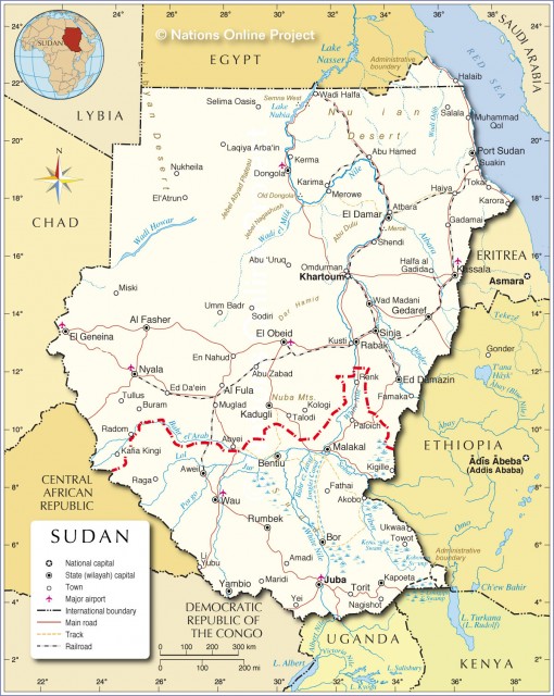
Created as a modern state in 1956 at the end of a period of British control, northern Sudan has a history dating to pharaonic times in Egypt. This heritage is because Sudan's central geographic feature is the NILE, which means that its people often are referred to as Nilotics.
Sudan's geopolitical position gives it unique importance in Africa. In the north, it is linked to Egypt and North Africa. To the east, it has historic ties to Ethiopia and eventually to the Islamic world via SAUDI ARABIA. To the west are Chad and the Central African Republic. To the south, it is linked most closely with the Africa of Congo, Kenya, and Uganda.
SUDANESE REGIONS
Physically, the modern state of Sudan can be divided into six largely unique regions, each with a distinct history and human geography:
- Northern Sudan and the capital of Khartoum. In most respects, this region is like Egypt to the north. It is narrowly defined by a small agricultural strip along the Nile River, and like Egypt, it has links to ports on the RED SEA. Its population is largely Nubian and the area has long seen a strong Arab and Islamic influence from Saudi Arabia.
- The Central Clay Plains. This is the most agriculturally productive area, which means it also has the largest nonurban population. It shares a border with Ethiopia.
- Western Sudan. In this semidesert region, the people are primarily pastoralists and non-Arab. However, they are Muslims by religion. It shares a border with Chad and was part of the famous 40-day road for commercial trade from Timbuktu to Khartoum and the Red Sea.
- Eastern Sudan. This region lies east of the Clay Plains and includes part of the Red Sea coastline and the Qash delta. It has a very strong Arab influence, including major investments in agriculture by Osama bin-Laden. It shares borders with both Ethiopia and Eritrea.
- The Southern Clay Plains. This area includes the large swamp known as the As Sudd, once a barrier to water transport between the region and Khartoum. The Sudd is approximately the size of BELGIUM. Most recently, the area has been the focus of a prolonged civil war. It shares borders with the Central African Republic as well as Ethiopia. Long a source of slaves for the slave trade, oil was discovered here in the 1970s and so those in Khartoum in the north now seek to extract this resource.
- The Ironstone Plateau. This area lies south of the Southern Clay Plains and the As Sudd. It shares borders with Congo, Uganda, Kenya, and Ethiopia and thus is more African than Arab. Of major importance is that this is a wet region with abundant precipitation and large areas of dense forest. In December 2003, the combatants in the long and bloody civil war finally agreed to cease hostilities and divide oil revenues equally.