Somalia
Area 246,333 square mi (638,000 square km)
Population 10.52 million (2014)
Capital Mogadishu
Highest Point 7,927 ft (2,416 m)
Lowest Point 0 m
GDP $5.707 billion (2014)
Primary Natural Resources banana, sugarcane, cotton, corn, sorghum.
SOMALIA OCCUPIES a strategic location along Africa's northeast coast at the southern approaches to BAB EL MANDEB and the route through RED SEA to the Suez Canal. The land is part of the famous HORN OF AFRICA and borders the Gulf of Aden and the INDIAN OCEAN, and lies to the east of ETHIOPIA. It is bounded by DJIBOUTI in the northwest, by Ethiopia in the west, by KENYA in the southwest, and by the Indian Ocean on the south and east.
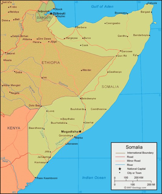
Physically, the outline of the borders is somewhat similar to the number seven as the land raps around Ethiopia to the west. Most of the landscape suffers from arid, semidesert conditions making it relatively unproductive for any type of sustainable agriculture. Most of the coastal area is a narrow strip of barren lowlands that rise abruptly to an interior plateau, which is generally 3,000 ft (910 m) high and stretches toward the northern and western highlands. There is a scrub-covered, semiarid, and generally drab maritime plain (the Guban) lying across the northern part of the country. Paralleling the Gulf of Aden coast, this plain is characterized by a hot and humid climate, low rainfall, and extremely sparse vegetation.
Moving away from the Gulf of Aden, the plain rises to the rugged mountain ranges that extend from the northwestern border with Ethiopia eastward to the tip of the Horn. Along this range occur the highest elevations in the country, including Mount Surud Cad, reaching an elevation of 7,897 feet (2,407 m) as well as precipitous north-facing cliffs that are part of very distinctive dissected highlands. The mountains give way in the south to the cooler and drier Hawd Plateau, while in the extreme south you find flat plains. The two major rivers, the Jubba and the Shabeelle, both of which rise in Ethiopia, flow southward across the country toward the Indian Ocean.
The climate is tropical and subtropical, with mean daily maximum temperatures often as high as 107 degrees F (42 degrees C) for days on end. Rainfall is scarce, but usually higher in the south and northwest with variations from 4 to 24 in (10 to 61 cm) over the country as a whole. In addition to Mogadishu, the other important cities are Hargeisa, Berbera (the main northern port), and Kismayo (the principal port of the south).
Somalia has not had a central government since the 1990s, especially after the overthrow of President Siad Barre in 1991. The country then entered a period of chaos because of intense fighting between rival warlords over control of Mogadishu. The country continues to be dominated by warlords responsible for small territories who are supported by heavily armed militias under their control.
Somalia became independent on July 1, 1960. It is the only true nation-state in Africa, because all Somalis are part of a Hamitic group on the basis of a common language, nomadic lifestyle, and Islamic religious heritage. However, the Hamitic group is broken into clans, which act as a unifying or dividing force.
By 1990, numerous clan-based armed resistance movements were attacking government troops. In 1991, Barre fled Mogadishu, which was seized by resistance forces of the United Somali Congress (USC). By the end of the year, the USC itself had split into two warring factions. Meanwhile in the north, the Somali National Movement (SNM) has declare the area under its control as a sovereign state namely Somaliland.