Djibouti
Area 8,958 square mi (23,000 square km)
Population 886,300 (2014)
Capital Djibouti
Highest Point Musa Ali 6,653 ft (2,028 m)
Lowest Point -550 ft (-168 m)
GDP $1.582 billion (2014)
Primary Natural Resources negligible.
BORDERED BY ETHIOPIA, ERITREA, and SOMALIA in Africa, the country of Djibouti (the former French Somaliland and then AFARS and Issas) is the epitome of a geopolitical state. It is a state that has been created and defined by its geographic location. Similar to GIBRALTAR and Aden, Djibouti controls access and egress from a major waterway: the Suez Canal and RED SEA. From 1862, Djibouti was controlled by the French, especially the French Foreign Legion, until 1977. In 2002, the UNITED STATES established a military base here. Were it not for its geopolitical value, there would be no economy beyond herding of goats and no political unit.
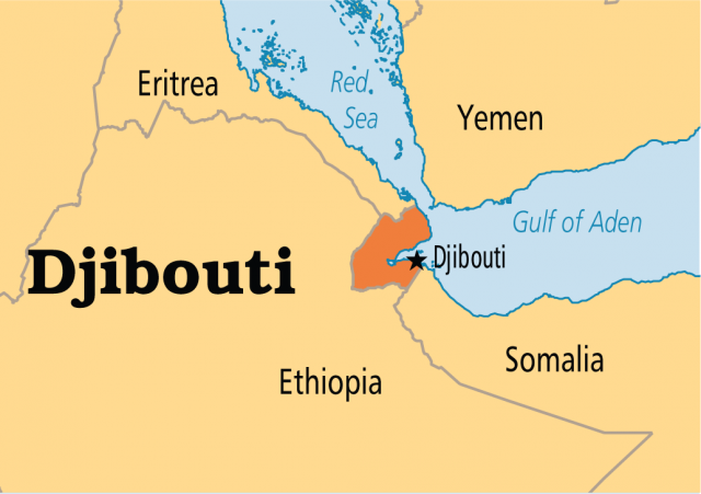
Small in area, with some features such as Lake Assal below sea level (550 ft or 168 m), Djibouti is arid and occupied primarily by pastoralists and refugees from the war between Ethiopia and Eritrea. Its deep harbor and the fact that all traffic to and from the Suez Canal (and thus Mediterranean Europe) must pass its location has made the area important far beyond any local resources—of which there virtually are none to speak of.
The only natural resource, other than its location, is the salt deposit at Lake Assal. However, salt is more easily and cheaply obtained in many other areas. The closest local parallel to the geopolitical value of Djibouti would be Aden, which also controls access to the BAB EL MANDEB, Red Sea and Suez Canal, but Aden was controlled by the British.
Djibouti also is located on a major fault (fracture) zone known as AFAR (for Africa/Arabia), where major geologic plates are separating and rotating, making it an extremely active earthquake and volcanic area as well.