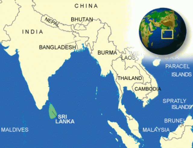
Sri Lanka
Area 25,332 square mi (65,610 square km)
Population 20.64 million 2014
Capital Colombo
Highest Point 8,280 ft (2,524 m)
Lowest Point 0 m
GDP $78.82 billion 2014
Primary Natural Resources limestone, graphite, mineral sands.
GEOLOGICALLY, THE ISLAND of Sri Lanka is considered a southerly extension of peninsular INDIA's Deccan region and was clearly part of the peninsula all through the last Ice Age. The pear-shaped island is approximately 140 mi (225 km) across at its widest point and about 270 mi (435 km) long and lies just 7 degrees north of the equator. The narrow northern end of the island is almost linked to southeastern India by a chain of limestone shoals known as Adam's Bridge.
Most of the island is flat or gently rolling terrain, although there is a mountainous section in the southcentral part of the country known as the Central Highlands that occupies most of the heart of the country. The highland landscape is highly dissected with a unique arrangement of plateaus, ridges, escarpments, intermontane basins, and valleys. There are also a series of spectacular escarpments such as World's End, a near-vertical precipice of about 4,000 ft (1,219 m).
RIDGES AND VALLEYS
Surrounding this highland is a interestingly diverse plain with elevations ranging from sea level to about 1,000 ft (300 m). To the north and northeast of the highlands, low ridges decrease in altitude as one moves toward the coast, traversing the plain. The western and southwestern parts of the plain feature alternating ridges and valleys that generally run parallel to the coast and increase in elevation toward the interior until they merge imperceptibly with the highland mass. In the remaining parts of the plain, rocky buttes and mounds, some of which reach elevations of more than 1,000 ft (305 m) sporadically interrupt an otherwise flat horizon. Surrounding the plain is a coastal zone consisting mostly of sandy beaches, spits, and lagoons. Over a few stretches of the coast there are rocky promontories and cliffs, deep-water bays, and offshore islets.
Sri Lanka's tropical location ensures perennially high temperatures, with monthly averages of 90 degrees F (32 degrees C) common in the lowlands. Despite its location just north of the equator, the higher altitudes of the Central Highlands account for surprisingly lower temperatures, where monthly averages can range between 44 degrees F (7 degrees C) and 71 degrees F (22 degrees C). Rainfall is the conspicuous factor in the seasonal and diurnal variations of Sri Lanka's MONSOON climate. Most parts of the country receive more than 50 in (127 cm) of rain per year.
However, regional differences created by Sri Lanka's geography have created distinctive wet and dry zones. The wet zone covers the southwestern part of the island including the highlands. The rest of the island constitutes a relative dry zone, where droughts are common and can persist for three months or more.
Today, the capital is at Sri Jayewardenapura Kotte. Colombo, the former capital (and still the site of many government offices), remains as the commercial capital and the country's largest city. The island has a moderate supply of minerals, but has become known more recently as one of the world's major suppliers of black tea.