Changjiang (Yangzi River)
THE CHANGJIANG cuts through the heart of CHINA and is regarded by the Chinese as the geographical marker dividing the country into north and south. It winds its way through the 10 provinces of Qinghai, Tibet, Yunnan, Sichuan, Hubei, Hunan, Jiangxi, Anhui, Jiangsu and Shanghai before reaching the East China Sea. Its fertile ALLUVIAL PLAINs produce great amounts of wheat, cotton, tobacco and silk. The Changjiang or Yangzi River dominates the center of China both north-south and east-west. It is thus one of the major factors affecting China's future industrialization and food production.
Changjiang means “long river” and that it is. China's Changjiang is the third-longest river in the world (after the AMAZON and NILE). It is over 3,960 mi (6,300 km) long and comparable in economic importance to the MISSISSIPPI in the UNITED STATES. Originating in the Tanggula Shan of eastern Tibet, the Changjiang passes through and links the fertile Red Basin of Sichuan province with the THREE GORGES and their new and massive hydroelectric project as well as the central food basket provinces of Hunan-Hubeh. It finally exits to the sea at Shanghai. Altogether it links eight provinces, several major urban and industrial cities and innumerable ecological regions.
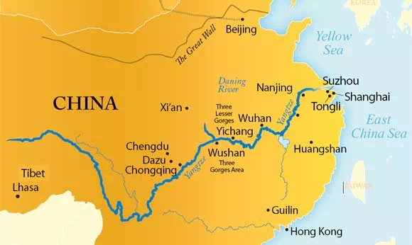
The Changjiang is China's longest navigable river; ocean-going ships are still able to pass as far inland as the Municipality (an autonomous city) of Chongqing. It also is China's major hydroelectric focus. The Three Gorges Project is designed to provide clean electric power to all of Sichuan and as far eastward as the Shanghai economic cluster. Just from Sichuan to Shanghai, the Changjiang corridor produces 40 percent of the nation's grain, including 70 percent of the rice, 33 percent of the cotton, 48 percent of the freshwater fish, and over 40 percent of the total industrial output, which is likely to increase significantly with completion of the Three Gorges project. And with an abundance of fresh water, there are plans to divert some to water-deficit areas in North China.
The key to understanding the geography, and thus the human significance, of the Changjiang is to realize that it is one river that links six distinct geographic environments and cultures. (Think of these as like a series of distinct boxcars along a rail line with the river being the connector or “line.” Each “car” contains distinct cities, climates, and economics.)
Chamdo-Tibet: This beginning of the Changjiang is an area of steep valleys, heavy snowfall, and strong springtime floods. None of the river is navigable, soils are rocky and slopes steep, thus preventing any largescale settlement by farmers. Most people are Tibetan or tribal and not of the dominant Han Chinese.
Sichuan: Leaving the TIBETAN PLATEAU the river's tributaries add water to form that portion in the Red Basin which was the site of the ancient Shu culture. Once a large lake, and with a mild climate, the Sichuan or Red Basin has very fertile soils. This has meant a surplus of food and a very large agrarian population. Until it reaches the area near modern Chongqing, it is navigable to only moderate-sized boats still capable of carrying significant cargoes.
Three Gorges: The site of the ancient Ba culture, the mountains that separate the Red Basin from the Central Plains of eastern China force the Changjiang into a narrow channel that contains a series of small inner basins with a mild climate but limited level land for agriculture. Most life focuses on the river, transportation, and light industry. There are three distinct gorges to pass through before the river debouches into the area known as eastern China. It is the final downstream gorge that has become the site for the controversial Three Gorges Dam. The area is designated ultimately to form a separate province (Sanxia or “Three Gorges”).
Liang Hu (Two lakes, Poyang and Dongting): Once past the Three Gorges, the Changjiang enters what has been called “China's rice bowl,” so named because of its abundant production. Stretching more than 630 mi (1,000 km), it is an area of many small and two large lakes, and because three other rivers enter the river here, it is prone to flooding. Historically, the basis for natural flood control was the fact that the two large lakes (Dongting and Poyang) could absorb the floodwaters. For example, Poyang Lake rises 36 ft (11 m) during the wet season. Dongting Lake expands to more than three times its dry season size and is more than 33 ft (10 m) deeper during the summer rains. This area supports immense agrarian and industrial populations and is a major east-west as well as north-south junction for transportation in all eastern China.
Dabie Mountains: The last CHOKE POINT for the Changjiang before it makes a final surge to the sea is created by the Dabie Mountains. The area is unsuitable for damming, but it still creates a constriction that often holds the river's high waters in the central basins, causing flooding. Were it not for the large lakes of Hunan and Jiangxi provinces, which can absorb much of these high waters, the entire area would have remained a lake or swampy area.
Nanjing to Shanghai: Between the one-time southern (nan) capital (jing) and Shanghai, the Changjiang has its greatest volume and flow. This section is wide and deep and has long been a kind of inland shipbuilding and port area. The area south of the river is largely mountainous and forest covered (thus providing timbers for boat building) and has a mild subtropical climate ideal for tea and citrus fruits, all of these being longtime specialties.
Today, Shanghai, at the mouth of this great river and despite its swampy physical geography, is China's largest and most modern city. It soon will replace HONG KONG as China's most international city, and the Changjiang will become one of the world's most important industrial arteries.