Old man River
Rivers, too, have their own hold on the human imagination. Most great cities that are not on the sea have a river running through them and would never have grown up without one. Nor is any painting of a wild landscape complete without flowing water.
At all points in its course, a river is best regarded as a transport system. Much as the amount of water it shifts varies over time, so does the quantity of other material such as sand, mud and rock that it can move. Winter, when there is most rain, and spring, when the snow melts, are peak times for river levels and for the erosion that goes with high water.
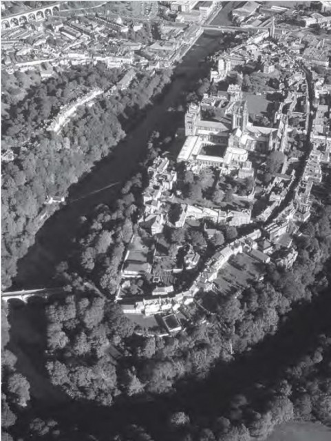
Rivers are at their most active when youthful. The mountains are the place to find the best waterfalls and rapids, which are the product of running water encountering harder and softer types of rock. In an era of rapid geological change, rivers are quick to change the landscape through which they run. This happened at the end of the last ice age, when new courses opened up for rivers and new valleys were cut A symptom of mountain-building or rising land levels is the presence of “incised meanders”. These are river bends in deep valleys, which have cut down as the land rose. One of the most spectacular surrounds the World Heritage Site at Durham, England. The sight of a piece of high land almost surrounded by a fast river was irresistible to medieval builders looking for a good defensive spot, so they enhanced nature by putting a magnificent castle and cathedral there.
Active rivers in high mountains erode the land through which they run both by water power and by the force of the rocks they carry with them. Sharp, fresh-looking rocks are characteristic of such rivers. Their banks are often marked by cracked and collapsing soil, protruding tree roots and other signs ot rapid change. But eventually even the busiest rivers reach some sort of armed truce with the landscape around them, and settle between banks that are broken only rarely.
More mature rivers follow a different set of rules, appropriate to their role of crossing comparatively flat land areas. Over its whole 6270km length, the Mississippi falls by just 12cm per kilometre. However, even these serene-looking rivers change over time as they erode their banks and eat away softer material preferentially. As we saw in Chapter 3, the rule is that on the outside of a river bend, the water is at its fastest and most aggressive, and erosion is at its most rapid. Speeds are slowest on the inside of the bend and material is more likely to be deposited there. Over time, this creates a series of wide bends, or meanders, in the rivers course. As the rivers path becomes more and more convoluted, the outside edges of two bends may eventually meet. Then the river cuts off the bend and straightens itself out, at least temporarily. The resulting cutout, called an oxbow lake, is one of the most distinctive structures on Earth.
The annual floods of the Nile, which provide thick, fertile sediment to the otherwise desert plains of Egypt, are proof that these apparently destructive natural processes are essential to life. There is always a fertile zone, the riparian corridor, along rivers even in the most hostile environments. But in the rich world especially, it is rare for mature rivers to be allowed to develop naturally. The land that they want to erode has owners who want to keep it. They argue for plenty of concrete to keep the river in its existing channel. By contrast, nobody has an interest in the new land that will emerge as the river shifts course. And while periodic flooding is natural, the people whose houses are in the way are quick to lobby for flood defence works to keep it in check.
When rivers reach the ocean
When rivers reach the sea, things become even more complex. A small stream can run into salt water without much ceremony. But a substantial river needs more, perhaps a delta or a full-scale estuary. A river delta, called alter the triangular-shaped Greek letter delta, is essentially a land area with some water, while an estuary is more of a watery area with some land.
A delta builds up when a river deposits more sediment than the sea can erode away. Instead of one unique route, the Hat topography of the deposits allows a number of solutions to the problem of getting water to the sea. The river cuts a number of distributaries which then start to meander so that some older parts become cut off. The definitive river delta is that of the Nile. But the delta formed by the mouths of the Danube as it enters the Black Sea in Romania is a more unspoilt example, as is the Lena River delta in Siberia.
Many river deltas occupy prime real estate – they are by the sea, on low-lying, fertile land. This means that the space they take up is in demand for farms, ports or factories. Often their untidy channels are straightened and deepened to allow ships to pass through. The mouth of the Rhone, on the Mediterranean coast of France, has been re-engineered with the addition of a new canal.
The basic equation of a delta or estuary is that when water slows to a halt, its ability to carry sediment drops to zero. This is why the Mississippi, which drains a vast area of the continental US, has generated a sediment area measuring 100km from north to south.
Even a river which carries too little sediment to build a delta can still carry enough material to silt up over time. This is especially true on a coast which is not being heavily eroded. In Britain, the west coast is rising and sediment is being deposited, so that major rivers such as the Mersey only stay open to shipping because they are dredged.
An estuary is a significant sheltered area of water where a river meets the sea. They are among the fastest-changing of all geographical features. Many, such as Chesapeake Bay on the Atlantic coast of the US, suffer severe erosion of their coasts and islands. The ecological value of estuaries lies in their basic property of mixing river and sea water. This means that they are home to many unique species of animals and plants which are adapted to changing salinity and to being exposed to air and water in turn several times a day. They are especially valuable as home to sea birds, shellfish including oysters, and seals and other marine mammals. Migratory birds often use them as stopover points on Earth-spanning flights.
The estuary of the Thames is a prime example. It stretches about 60km inland, with its inner reaches in London. Both banks are marked by a succession of marshes and areas of grassland. Even the wilder-looking parts are used for grazing cattle. The main distinction to be made between different areas of the seashore is whether they are marshland that floods at every tide – or perhaps every high tide – or flood plain, which gets sub-merged only when exceptional amounts of water are coming up or down the river, or doing both at once. Often the temptation to build on the flood plain is irresistible to developers. Flood defences can help buy time for their developments but the inevitable end is a damp one, and arrives all the more rapidly in an era of sea level rise.