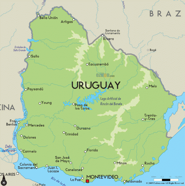
Uruguay
Area 68,039square mi (176,220 squarekm)
Population 3.420 million 2014
Capital Montevideo
HighestPoint 1,686 ft (514 m)
LowestPoint 0 m
GDP $57.47 billion 2014
Primary Natural Resources rice, wheat,corn, barley, livestock, fish.
THE ORIENTAL REPUBLIC of Uruguay, more simply known as Uruguay, is a South American country with a population of about 3.4 million people and situated along the ATLANTIC OCEAN between ARGENTINA and BRAZIL. The capital, Montevideo, is the seat of the three-branch federal government, consisting of a strong executive whose power is constrained by checks from the legislative and judicial branches. Governmental administration separates Uruguay into 19 different departments, which communicate with the federal government through a subordinate governor. Even though Uruguay's constitution has been in existence since 1967, the military took control of the government for most of the 1970s and early 1980s. The year 1989 marked the country's first free elections since the restoration of civilian government.
Following an international policy founded upon nonintervention, dialogue, and regional development, Uruguay has succeeded in establishing one of the most stable and free societies in South America. Uruguay's economy suffered a major downturn starting in 1999 and lasting until 2002, threatening the country's status and stability as unemployment skyrocketed to almost 20 percent. Lower demand for goods in Argentina and Brazil sparked the downturn, but fears were calmed when Uruguay was able to sign a debt restructuring agreement with the International Monetary Fund and the UNITED STATES.
ROLLING PLAINS
The lands of Uruguay cover an area slightly smaller than the state of WASHINGTON. The lands are sometimes referred to as a geographic transition between the relatively featureless Argentine plains on one border to the hilly lands of southern Brazil. Consequently, the majority of Uruguay's territory is classified geographically as rolling plains. Flat plains are found along the country's eastern, southern, and western borders, while the interior consists of rolling plains and hills. The Atlantic coast is marshy and sandy with a number of shallow lagoon inlets, whereas the coasts of the Rio de la Plata and the Rio Uruguay are less wet and broader.
Uruguay's most valuable resource is water, since prominent bodies of water form the country's eastern, southern, and western borders. There are a number of sizable lakes situated in the interior of the country, which also has a high water table allowing for the digging of wells and the establishment of irrigation where necessary. Three major river systems are found within Uruguay's territory, which drain into the Rio Uruguay and the Atlantic Ocean. The most important river is the Rio Negro, which crosses the country from northeast to west, draining into the Rio Uruguay. It is dammed, creating the largest reservoir in South America, known as the Embalse del Rio Negro.
Thanks to the country's rolling plains and lack of mountains, Uruguay's entire climate is temperate and fairly uniform nationwide. In addition, the lack of mountains makes the lands vulnerable to high winds and quick changes in weather. Seasons differ, as spring is damp and cool; summers are warm but cooled by ocean winds; autumns are relatively mild; and winters are cold and often extremely damp.