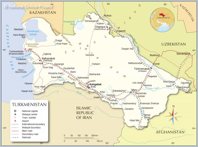
Turkmenistan
Area 188,456 square mi (488,100 square km)
Population 5.307 million 2014
Capital Ashgabat
Highest Point 10,298 ft (3,139 m)
Lowest Point -265 ft (-81 m)
GDP $47.93 billion 2014
Primary Natural Resources petroleum, natural gas, coal.
TURKMENISTAN, KNOWN for its deserts, oil potential, and strong authoritarian government, achieved its independence in 1991 following the collapse of the Soviet Union. The sparsely populated republic borders the CASPIAN SEA to the west, KAZAKHSTAN to the northwest, UZBEKISTAN to the north and east, AFGHANISTAN to the southeast, and IRAN to the south.
The topography of Turkmenistan is dominated by the Turon Depression and the Garagum Desert, which comprises 80 percent of the country's area. Limited mountainous areas exist within the KOPET MOUNTAIN range along the southwestern Iranian border. Turkmenistan's climate is predominantly continental subtropical desert, with very little rainfall. The availability of water is a pressing issue, with the vast majority of the country lacking a constant water source. Turkmenistan borders the Caspian Sea and contains much of the AMU DARYA, the longest river in Central Asia.

Turkmenistan is also home to the Garagum Canal, which stretches from the Amu Darya in the east near the Afghan border for 700 mi (1,100 km) into the southern desert. Soviet planners began the canal during the 1950s, and current efforts are under way to push the canal to the Caspian Sea. While the canal has brought significant acreage into cultivation, it has also diverted water from the Amu Darya and contributed to the shrinkage of the ARAL SEA. Although not bordering the Aral Sea, Turkmenistan continues to suffer the associated consequences of unsanitary drinking water and high infant mortality. Turkmenistan's Kopet dag region is seismically active, as the capital city of Ashgabat was destroyed in a 1948 earthquake.
Turkmenistan's relatively sparse population is centered on the capital city of Ashgabat, with minor concentrations in the western Caspian Sea basin around Turkmenbashhi and Nebit Dag and an eastern concentration around Mary and Charjew. Ethnically, Turkmenistan is made up of Turkmen (85 percent), Uzbek (5 percent), and Russian (4 percent) peoples. The major religions in Turkmenistan are ISLAM (practiced by 89 percent of the population) and Eastern Orthodox (9 percent). Major languages spoken in Turkmenistan include Turkmen (spoken by 72 percent of the people), Russian (spoken by 12 percent), and Uzbek (spoken by 9 percent).
Turkmenistan's economy is dominated by the primary sector, including natural gas and oil extraction and agricultural production of cotton. Economic data are classified as “state secret,” although international estimates place the proportion of Turkmenistan's population living below the poverty line at 50 percent. Turkmenistan has been slow to adopt market reforms, and state-run control of the economy is still strong. The authoritarian regime of President Saparmurat Niyazov (self-proclaimed Turkmenbashi, or “leader of the Turkmen”) has outlawed all opposition political parties. The tradition of carpet making continues in Turkmenistan, considered the source of the highestquality wool and silk carpets in the world.
Turkmenistan is plagued by a poor relative location. While well endowed with oil and natural gas resources, a relatively poor human resource base and lack of export infrastructure hinder Turkmenistan's economic development. Turkistan's delivery of Caspian Basin natural gas and petroleum to world markets remains a problem. Any potential export routes must pass through Iran, AZERBAIJAN, or RUSSIA. Additional issues confronting Turkmenistan include slow privatization of the economy, widespread poverty, and relatively high levels of external debt.