Tanzania
Area 364,900 square mi (945,087 square km)
Population 51.82 million (2014)
Capital Dar es Salaam
Highest Point 19,340 ft (5,895 m)
Lowest Point 0 m
GDP $48.06 billion (2014)
Primary Natural Resources coal, diamonds, gemstones, gold.
TANZANIA IS A LARGE COUNTRY located on the INDIAN OCEAN in eastern Africa. It was formerly known as Tanganyika. In 1964, Tanganyika united with the Island of Zanzibar to form the United Republic of Tanzania. Tanzania is bordered by eight other African countries. KENYA and UGANDA are it neighbors to the north. To the west lie RWANDA, BURUNDI, and the Democratic Republic of the CONGO. ZAMBIa and MALAWI border the southwest. In the south, the country borders MOZAMBIQUE.
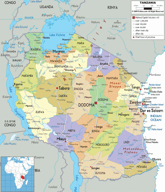
The Indian Ocean is the eastern edge of Tanzania. The coast line is over 500 mi (800 km) long. Tanzania, located between the equator and 12 degrees South, is a hot country. Along the coast are many mangrove swamps and coconut palm groves. The coast is always warm, but the temperate highlands can be cool. Tanzania has a tropical wet-dry climate with the rains coming in late November.
ZANZIBAR
There are three islands off the coast of Tanzania. Pemba Island is the most northern island. It is only 380 square mi (984 square km) in area. To its south is Zanzibar, the largest of Tanzania's islands. Zanzibar Island is the largest of Africa's coral islands, but it is only 640 square mi (1,658 square km) in area. The Zanzibar Channel separates Zanzibar Island from the mainland. This strait is 22 mi (40 km) wide. Both Zanzibar and Pemba are famous for producing the sweet spice cloves. Smaller Mafia Island is to the south.
The bulk of Tanzania is a plateau that rises from the Indian Ocean to an average level of about 4,000 ft (1,200 m). The plateaus are hot with open savannas of grass, thorn trees, and brush. There are many mountains and mountains ranges on the plateaus: The Usambara Mountains are located in northeastern Tanzania; Mount KILIMANJARO, which used to have snow on its peak year-round, is in the northeast.
The Serengeti Plain, famous for its vast herds of African animals, lies in the north on a high plateau between the Ngorongoro highlands and the border with Kenya. South of the Serengeti is the Masai Steppe. Northwest is the southern third of Lake VICTORIA in the extreme north of the country. The OLDUVAI GORGE, which is a 30-mi (48-km) long trench, lies in the Serengeti Plain. Tanzania's western borders include Lake TANGANYIKA in the west and Lake Nysa (Lake MALAWI) in the southwest. These are rift valley lakes formed in the Great Rift Valley. Both lakes have bottoms that are below sea level.
The Hahali Mountains and the Ufipa Plateau overlook Lake Tanganyika. The Kipengere and Livingstone mountains overlook Lake Nyasa. The Malagarasi Swamp in the western central plateau was formed by the geologic rifting of the continent. The south-central region contains the Great Ruaha Rift. It bounds the Ruaha National Park.