Malawi, Lake
LAKE MALAWI IS LOCATED in southeastern Africa lying within the crease where the eastern and western branches of the Great Rift Valley meet. According to the Center of Great Lakes Studies, Lake Malawi is the ninth-largest lake in the world by area and the fifthlargest lake in the world by volume. Malawi is the third-largest lake in Africa, covering 11,600 square mi (30,044 square km), and is 375 mi (603 km) long and from 15 to 54 mi (24 to 87 km) wide. The lake is at 1,550 ft (471 m) elevation and reaches a maximum depth of 2,487 ft (758 m). It is bordered on the south and west by the country of MALAWI, on the north and east by TANZANIA, and by MOZAMBIQUE to the east. The Malawi-Tanzania border follows the northeastern shoreline of Lake Malawi. The Malawi-Mozambique border runs along the center of the southern part of the lake, with the exception of the islands of Likoma and Chisumulu, which belong to Malawi. Likoma is the largest island on the lake.
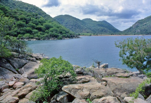
The lake is a major tourist destination in this part of Africa, and many resorts have been developed along the southern shores of the lake, where the water is shallower and there are many beautiful white sandy beaches. With the exception of the southern portion of the lake, steep mountain slopes surround Malawi. The Livingstone Mountains rise from the northeastern shore of the lake and are covered by dense forests. Along the north shore of the lake grow thick beds of papyrus reeds, which are the nesting grounds for several species of birds, including kingfishers, cormorants, fish-eagles, and numerous others.
Other inhabitants of the lake include hippopotamuses and crocodiles. Much of the lake's economy is based upon tourists and fishing. The natives that live around the lake bring in over 7,000 tons of fish per year. Most of the fish is dried and used locally, but some of it is exported.
From the north in Tanzania, Lake Malawi is fed by the Ruhuhu River and from the west three small mountain streams, Bua, Dwangwa, and Songwe, feed the lake. The Shire River flows out of Lake Malawi at its southern end and is a tributary of the great Zambezi River. The Shire is greatly affected by the level of the lake, which varies by up to 20 ft (6 m). These changes in water level have been studied and, because they occur every 11years, are believed to be linked to the sunspot cycle.
Lake Malawi could also be known as the lake with many names. Prior to the 18th century, the lake was known as Zaflan, Zambre, Hemozura, and Lake Maravi. In 1859, David Livingstone was the first European to map Lake Malawi. At that time, it was named by Livingstone as Lake Nyasa, which was its native name meaning simply “lake.”
In 1964, Nyasaland, formerly a British Commonwealth, became the fully independent country of Malawi, and Lake Nyasa became Lake Malawi to the Malawi people. In Mozambique, they still call the lake Niassa, according to the Portuguese spelling of Nyasa. In literature, it is called Lake of Stars, for the sun glittering off the lake during sunset, and Lake of Storms, for the unpredictable and extremely violent gales that sweep through the area.