Delimiting the CBD
Just as the CBD has evolved through a number of different stages there have been various attempts to delimit its boundaries traditionally defined by a 'blighted zone' (of discard), characterized by obsolete and deteriorated property. At the most visible level the CBD can be delimited by the highest buildings, the heaviest concentration of traffic and pedestrian flows, and a large daytime working population and a low residential population. However, there is general agreement that these observations only provide crude indicators of the CBD's magnetism and are therefore not entirely satisfactory.
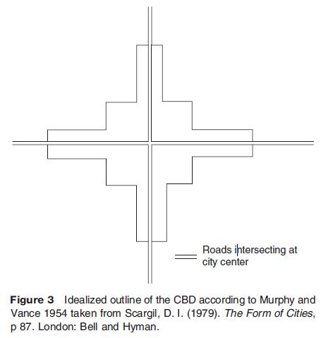
The main theoretical contributions for delimiting the CBD have come from approaches that employ land values and indices. These include floor space, business intensity, and valuation of properties. The application of land rent is based upon earlier principles most associated with von Thunen's explanation of agricultural land uses. His central idea is that the economic gain from farming land decreases with an increase in distance from the market (CBD) due to more expensive transport costs. In urban environments the general assumption with land value delimitations is that individual land uses will compete for the most desirable central location in or as near to the CBD as possible. Potential benefits can include unique attributes such as strategic location, local market demand, integration with regional clusters, and human resources. However, these potential benefits come at a cost of having to pay the highest amount of rent to be closest to or at the peak land value intersection (PLVI). This is an area in the CBD where the main roads and other transport links intersect, but the actual position of the PLVI can shift depending on the direction of CBD growth along the zone of assimilation. A useful generalization based on North American cities shows how the CBD builds up around the PLVI first before extending out along the main transport corridors (Figure 3). Any further increases in distance away from the PLVI means a drop in land values which in turn produces changing physical urban land use patterns (retail, office, and residential).
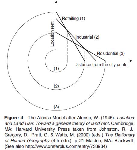
The schematic representation in Figure 3 is based on the land value surface that is, a reflection of accessibility within the urban area. Since accessibility differs across the urban area land use patterns are based on the ability to pay rent for the most accessible locations in the CBD. This is supported by a number of other models which suggest that the land use most dependent upon accessibility outbids other potential users. Figure 4 shows that retailing (usually malls, department stores, and flagship stores) is most dependent upon accessibility followed by offices and then residential land uses. The resulting type of land use pattern is also associated with steeper declines in the offer price curve for those functions (retailing) that are most dependent upon a central location.