Competitiveness
Introduction Although rarely confronted directly, competitiveness is a central concept in economic geography. In location and regional development theories, and in their work on industrial restructuring, uneven development, industrial district formation, learning regions, and neoliberalization, economic geographers have asked what gives particular advantages to enterprises located in particular places. Far from unified in their approaches to this question, different authors have […]
Community
Community is one of those concepts about which social and cultural geographers worry. It is a difficult term to tie down, and it is used in a myriad of ways by all spectrums of society. In his influential Keywords, Raymond Williams points out that unlike other terms for social relations, such as state and nation, and even society, the term 'community' […]
Communist and Post-Communist Geographies
Efforts in geography to address the issues of socialism/communism failed to be seminal to the emergence of any powerful theory that could have been the result of putting the perspective of scientific communism on geography. It was the political economic approach of Marxism that imbued the geographies of state socialist countries the profoundly. Human geography was replaced with economic geography. […]
Communicable Diseases, Globalization of
Introduction Communicable diseases are the greatest disease threat facing humankind. Diseases previously considered eradicated are re emerging and new viruses are emerging. Due to increased human population and accelerated global travel, local outbreaks become instant global threats. Despite technological advances in medicine, devastating communicable diseases such as Ebola, severe acute respiratory syndrome (SARS) or avian influenza continue to surface and ravage humankind. […]
Commodity Chains
Commodity Chains: An Introduction The production of any commodity, whether it be a manufactured product or a service, involves an intricate articulation of individual activities and transactions across space and time. Such production networks – the nexus of interconnected functions and operations through which goods and services are produced and distributed – have become not only organizationally more complex but also increasingly […]
Color, Mapping
Introduction The word color is often associated with sensations that are named, such as red, blue, purple, and brown. However, the phenomenon of color is actually multidimensional. Color can be differentiated along three different dimensions: hue, lightness, and saturation. Color hue is related to the wavelengths of light that are perceived by the map reader, and is typically described […]
Colonialism, Internal
Definition Internal colonialism refers to a complex set of sociospatial relationships of exploitation and domination that characterize certain culturally distinct populations residing in sovereign, mainly ThirdWorld, societies. The two defining relationships of internal colonialism are that subjected populations are (1) exploited principally by mechanisms which may not be 'capitalist proper' and (2) institutionally dominated, both politically and culturally. In the first […]
Colonialism II
New Imperialisms, New Colonialisms, and New Political Geographies The later decades of the nineteenth century and the first years of the twentieth century witnessed European colonialism accelerate in pace and expand in scale. By 1914, much of the world was shaped by this process and its attendant, entwined webs of trade, migrants, political power, and knowledge. Historians usually trace this […]
Colonialism I
Introduction In recent years, there has been an enormous body of work which tries to understand modern European colonialism in all of its economic, social, and cultural dimensions, and to grapple with its legacies. The focus of this article is especially on British and, to a lesser extent, on French colonialism up to about 1870. The terms 'colonialism' and 'imperialism' […]
Cold War
The Cold War was named in 1947 by Bernard Baruch in his advisory role to President Truman as the United States, Great Britain, France, and its other Western allies faced off against the Soviet Union, with mutually aggressive maneuvers and countermoves, especially in Europe. This label was publicized more broadly by Walter Lippmann in a 1947 book with same name, […]

Cohen, S.
Cohen, Saul (1925–) Born in Malden, Massachusetts, and was educated in Boston, Saul Cohen graduated in geography of Harvard (MA 1948, PhD 1954) and served in Europe in World War II. A liberal Democrat, he is married to Miriam, has two daughters and seven grandchildren. In 50 prolific years of writing, teaching, and studying in geography, Saul Bernard Cohen has […]
Cognitive Geography
What Is Cognitive Geography? Cognitive geography is the study of cognition, primarily human cognition, about space, place, and environment. Cognition is knowledge and knowing by sentient entities, including humans, nonhuman animals, and artificially intelligent machines. Cognitive structures and processes include those of sensation, perception, thinking, learning, memory, attention, imagination, conceptualization, language, and reasoning and problem solving. Some of these structures and processes […]

Cloke, P.
Cloke, Paul (1956 –) Professor of Human Geography at the University of Exeter, England, having previously worked in geography departments at Lampeter, Wales, and Bristol, England; by the early 1990s Martin Bodman identified Paul Cloke as an emerging 'master weaver' in human geography, a phrase used to characterize people having a significant influence within the discipline. Bodman argued that Cloke was one […]
Climate Change
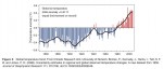
Introduction Communities which cope with climatic hazards by im plicitly assuming a continuance of the status quo learn harsh lessons. Despite this, quite limited adaptation to known risks is often apparent in contemporary society. In the past, the catastrophe of harvest failure led to sometimes quite sophisticated coping responses and the shunning of areas of known high risk based on […]

Claval, P.
Claval, Paul (1932–) Paul Claval, born in Paris in 1932, is one of the most important geographers of his generation, both in terms of the extensive nature of his work and his originality, eclecticism, and international influence. His passion for geography developed during his teenage years in south-western France. While accompanying his father on summer work trips, Claval very quickly […]

Civil Society
Introduction Civil society is a contested term that broadly describes the arena of collective social interaction situated between the state, market, and household. Despite being used in a normative manner to encompass a host of values linked with participation and cooperation, it is more commonly used to describe a range of formal and informal nonstate organizations, groups, and associations that form […]
City-Region
Origin of the City-Region Since the 1990s, there has been a remarkable resurgence of the concept of the city-region in both academic and policy communities. In broad terms, the concept articulates the relationships between the city and its environs. For almost 30 years the focus on the city-region had been overshadowed by a shift of emphasis toward urban and particularly […]
City Marketing
Introduction Classic city slogans like ''I ? New York'' and ''Glasgow's Miles Better'' are so embedded in the popular consciousness as to have long outlasted their official use by their respective municipalities, chambers of commerce, and convention and visitors bureaus. Cities and towns are increasingly associated with symbols, slogans, or taglines (''What Happens Here Stays Here. Las Vegas'' or ''Johannesburg. A […]
Citizenship and Governmentality, Rural
Introduction In its most straightforward sense, citizenship is understood as bestowing upon individuals a legal status as members of a national polity, enacted by state apparatus and defended by legal and administrative rule and regulations. As members of that polity, individuals are entitled to certain political, civic, economic, and social rights, including individual freedom of speech, rights to property, the right […]
Citizenship
Introduction Citizenship refers to particular ways of being situated within and responding to relations of power through which a community is governed or ruled. It involves claiming, exercising, and contesting rights, entitlements, and obligations (e.g., rights to vote and strike, the obligation to pay taxes) and diverse ways of engaging with the institutions (such as the state) and relations through which […]
Chronic Disease
Introduction Chronic diseases are ongoing/recurring, not caused by infection, or passed on by contact. They generally cannot be prevented by vaccines, do not resolve spontaneously, and are rarely cured by medication or other medical procedures. Chronic diseases are often caused by a combination of health damaging behaviors (smoking, drinking, high fat diet, and physical inactivity) and exposure to socioenvironmental conditions (stressful […]
Christian Geography
Introduction Many a different adjective and prepositional phrase added to the word 'geography' has become common currency to identify and parcel out geography's distinctive fields, topics, regions, paradigms, approaches, research groups, national traditions, and historical periods. Christian is almost never one of them. There is Berkeley geography, Classical geography, the geography of aging, Japanese geography, idealist geography, the geography of the […]
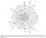
Christaller, W.
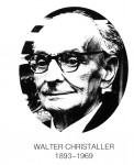
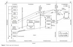
Walter Christaller (Figure 1), a German geographer and one of the founding fathers of the 'central place theory', was born on 21 April 1893 in Berneck in the Black Forest, and died on 9 March 1969 in Ko?nigstein in Taunus (Hesse), at the age of 75. His mother belonged to a cultured middle class family of Darmstadt and in her mature […]
Choice Modeling
Introduction A conventional premise of microeconomic theory is that demand and supply are traded off through continuous adjustments in quantities. Individual demand is determined by calculus methods that maximize consumer utility (i.e., satisfaction), subject to constraints. By the 1970s, it had become clear from the pioneering work undertaken in transportation, marketing, and economics that many consumer decisions do not conform to […]
Chinese-Language Geography
A Long History of Chinese Human Geography Recognition of Human–Land Relation during the Formative Stage Human geography started to flourish in China more than 2500 years ago. The concept of 'geography' was first coined in the classic text of Yi Jing (or I Ching, Book of Changes), referring to the observation and understanding of the Earth's surface for the pursuance of […]
The Persistence of the State in Chinese Urbanism
It is clear that Chinese urbanism has evolved differently under different historical contexts. It has always contributed to state formation while reflecting the national concerns of the period in question. What sets Chinese urbanism apart from the urbanisms elsewhere is the persistently strong role of the state in shaping its character that began with China's first cities in the […]
Multiplex Urbanism in the Reform Era
China's dramatic urban transformation since the 1978 reforms is a consequence of the interplay between exogenous and endogenous forces at global, national, and local scales. As elsewhere, globalization and neoliberalism have strongly impacted the Chinese economy, but major endogenous policy shifts have been more important in effecting changes in the Chinese city, including the initiation of the policies of […]
Socialist Urbanism (1949–1978)
Socialist urbanism in China was created very quickly during the first three decades of Communist rule. From 1949 to 1978, cities served two major functions. First, they continued to serve as centers of national and local administration, a function that directly affected their growth. Second, cities played a passive supporting role in China's centrally planned socialist industrialization, serving essentially as spatial containers […]
The Arrival of the West and Modernist Urbanism (1840–1949)
Urbanism in China experienced a dramatic change in the mid nineteenth-century when increasing numbers of Western traders arrived in China demanding expanded trade along the China coast, which precipitated the Opium War (1839–1842) between the British and Chinese empires. China's loss of the Opium War and other subsequent wars with foreign powers resulted in a series of unequal treaties that forced […]
Administrative and Commercial Urbanism (770 BC–AD 1840)
Childe's key criteria defining early cities in the Old World show clearly the importance of economic production and trade in the rise of its early cities, and economic factors have remained dominant in subsequent Western urban history. In China, during the Zhou period (c. 1122–256 BC), a politically fragmentary era with many independent states contending for territory and superiority, […]
Neolithic Settlements and Incipient Urbanism (c. 5000–770 BC)
As in other parts of the world, early Chinese towns evolved from villages. During the Middle Neolithic era (c. 6500–5000 BC), large sedentary villages with a few hundred people based mainly on agriculture and animal domestication had emerged. Widely distributed in China, many of the villages were surrounded by circular ditches and walls constructed with the hangtu (tamped earth) technique, whereby layers […]
Chinese Urbanism
Cities are complex spatial entities consisting of economic, social, political, and cultural dimensions that differ significantly in different cultures, where they tend to undergo varying patterns of transformation over time. Cities and states are dynamically related and mutually constituted, with the former often embodying the essence of the latter. This is especially true in the case of China. Relative to other […]
Critiques and Challenges
Outside of academia, the children's rights movement has, as yet, had only limited success. The global position of children remains poor, with significant numbers of children lacking a basic education, clean water, or food. The UN Convention has been criticized for trying to impose a global vision of childhood which fails to adequately recognize cultural differences or varying needs. Moreover […]
Children’s Experiences of Place
The following section will explore one of the key contributions geographers are making to the study of childhood, by focusing on the empirical work geographers are doing in the everyday spaces of childhood which shape (and are shaped by) their lives. The Home The home is an important site for the negotiation of child–adult power relations. The home […]
The Spatial Construction of Childhood
One of the most important ways in which human geography can enhance our understanding of childhood is to highlight the importance of space and place to children's lives. Geographers question essentialist notions of a universal child by illustrating through diverse empirical studies the ways in which children's experiences vary in different places and in different contexts. The notion of what constitutes […]
Children’s Geographies
The following sections will explore children's geographies by drawing on a range of empirically rich material from both the 'minority and majority world', to highlight the relationships between children and the spaces they inhabit. The first part will explore the socioeconomic structures, institutions, discourses, etc. – including globalization, 'development', and poverty that 'place' children in particular ways. The second part […]
Theoretical Concepts
The Social Constructedness of Childhood The concept of a socially constructed child is relatively new in geography. It developed in part as a response to the crisis of representation in the social sciences which began in the mid 1970s. Focusing on academic texts, concern was expressed over the ability of academics to misrepresent others through their writing. Children were viewed as […]
Origins of Work on Children by Human Geographers
Children remained absent from most geographical work until William Bunge's detailed empirical studies of Detroit and Toronto in the early 1970s, in which he focused on the spatial oppression of children in the built environment. At a time when geography was heavily dominated by the quantitative revolution, Bunge used a variety of methods including observation of children at play to highlight […]
Definitions
Defining childhood is problematic due to the spatial and temporal fluidity of prevalent ideas and laws pertaining to children. On one level, the definition used by many human geographers and other social scientists reflects the 1989 UN Convention on the Rights of the Child, which defines childhood as the period up to 18 years of age. However, while this implies that […]
Children/Childhood
Definitions Origins of Work on Children by Human Geographers Theoretical Concepts Children's Geographies The Spatial Construction of Childhood Children's Experiences of Place Critiques and Challenges
Children as Map Users in the Information Technology Era
Cartography at the beginning of twenty first century is facing a technological revolution due to the widespread use of electronic media and especially of computers and information technology. In many countries, individuals have access to a computer usually connected to a worldwide network everyday. Such a technological advance not only affects the technical frame of cartography, but it also changes […]
Understanding the Basic Characteristics of Maps
The achievement of cartographic understanding has, as a prerequisite, the understanding of the basic characteristics of maps. Scale, map projections, generalization, and symbolization are common to every map and are considered as basic characteristics of maps. Since map literacy is not systematically included in the school curriculum, there are no definite and clear results referring to children's understanding […]
Understanding Spatial Representations
Using Models According to Piaget, children of about 7 years of age start to appreciate the model as a representation. Experimental studies in 1991 with children of ages between 2.5 and 3 years found that children appear to appreciate the correspondence between a room and a model at the age of 3 years, having more success when the room […]
Development of Cartographic Understanding
The development of cartographic understanding has been approached from four different theoretical per spectives. The Nativist Approach The first one, the nativist, posits that cartographic understanding is innate. Three kinds of argument have been advanced for this perspective. The first one comes from a particular view concerning evolutionary development, according to which much of the structure of human mind is innately […]
Children and Mapping
The topic of children and mapping is a special subject within the broad area that examines the ways people see and interpret maps. Children are a special case of map users for two reasons. The first one pertains to the relation between the development of children's conception of space and that of cartographic understanding. The theories of the children's spatial […]
Causes: Why Do Children Work?
Whether children work is not a question of choice for many children or their families. The causes of child labor usually stem from poverty and underdevelopment, but this is not the only reason why children work. They also work as a result of other structural constraints, including the failure of the education system, unemployment and underemployment, vested interests of employers, and rapid […]
Legislation: Protection or Abolition?
The UN Convention on the Rights of the Child states that exploitative child labor should be eliminated, but the Convention's recommendations ''may not be realistic for all countries, especially those whose economies and educational facilities are insufficiently developed'' (Bequele and Myers, 1995: 93). The International Labour Organization (ILO) has been striving to ban child labor since 1919, and the ILO's Minimum Age […]
Definitions: Child Work versus Labor
There has been an ongoing debate about how children's labor is conceptualized: whether it is positive and a form of socialization, or negative and a form of exploitation. This led to a distinction between the definitions used to describe children's activities. 'Child work' was considered to be acceptable, a social good and a form of socialization useful for children's future […]
Child Labor
Throughout the world, many children play a key role in both productive and reproductive household labor, and may contribute to their household maintenance in both paid and unpaid ways. However, many children's tasks are not recognized as work and can be underestimated or undervalued. For example, domestic labor is considered something that children should automatically carry out without pay. In this sense, […]
Other Chicago’s
In the process of locating knowledge, in a particular discipline and a particular place, exclusions occur. This may not be a serious problem if histories and geographies of ideas identify only loosely bound places that are argued to be key nodes in the production of knowledge. However, in the case of the Chicago School, narratives that claim so much for […]
Human Geography and the Chicago School
The first commentaries on Chicago sociology in geography are found in spatial science texts in the 1960s, with reference only to Burgess. Barry Garner, writing in 1967, referred to the 'classic' concentric zone model of Burgess that described the typical succession of land uses with distance from the city center. Walter Isard, in 1956, and Brian Berry, in 1959, had […]
Chicago School
The Chicago School discussed in this article is that University's Department of Sociology, although Chicago has, or had, other celebrated schools, such as The School of Economics and The School of Pragmatism. The term 'school' may suggest a group of scholars working closely together and sharing philosophies and methods, as in Plato's academy. It may also suggest something rather special – a […]
The Complexity of Complexity
There is a determination by many theorists to show that complexity is the new unifying interdisciplinarity – even bridging the science–society gap. But the case is not yet proven, and it may be that there are different types of complexities in different realms. As suggested above although computation can now produce lifelike simulations, perhaps complexity is usually associated with living […]
Measuring Complexity
Some things clearly are more complicated than others. By this account, it ought to be possible to provide a quantitative measure of complexity, so that the extent to which 'this' is more complicated than 'that' can be expressed accurately. Many authors believe that no measure of complexity has yet been discovered that has any useful meaning. They believe no such […]
The Big-Top of Complexity
Many of the topics which now vie for attention within the complexity circus had their origin somewhat outside of the new field, or before the new tent was erected. Examples include artificial intelligence, which itself comes in a variety of incommensurate forms. These include expert systems, which quarry human experts such as doctors diagnosing a patient, to elicit the rules […]
Chaos and Complexity
There is a reasonable consensus on what the study of chaotic systems means, but there is very little consensus on what the study of complexity entails – it is a vaguely defined emerging field that is currently an unwieldy alliance of problems, aspirations, insights, and technologies. Most definitions start with a minimum requirement that many parts are involved in nonlinear […]
Impacts on Urban Geography
There has been considerable support both for and against the overall effectiveness of central place theory in describing and explaining the locational relationships of central places and their market areas. On the one hand, the theory has been criticized for its emphasis on description rather than explanation. The classical models are extremely rigid and deterministic. They predict a partial equilibrium […]
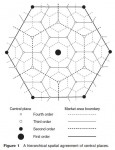
Classical Central Place Theory
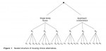
A Single-Function Central Place System The central place model is based on a series of simplifying assumptions. It assumes that economic activities are taking place on an isotropic surface – an idealized region which is completely flat and homogeneous in every respect. This implies that there are no barriers to movement and the transportation cost per unit of distance is […]
Central Place Theory
Central place theory is concerned with the size, number, functional characteristics, and spacing of settlements, which are nodal points for the distribution of goods and services to surrounding market areas. An interest in some aspects of the theory can be traced back to the eighteenth and nineteenth-century, when German scholars attempted to identify the relations between settlements and their complementary regions. […]
The CBD and the Threat of Decentralization
Many changes have occurred in Western society since 1945 that have implications for the twentiethfirst century CBD. These changes include fluctuating urban economic performance, the rise of global neoliberalism, and advances in process and product technologies. Notwithstanding, it is now near customary to claim that decentralization, especially in retailing, has had the biggest impact on the fate of the […]
Delimiting the CBD
Just as the CBD has evolved through a number of different stages there have been various attempts to delimit its boundaries traditionally defined by a 'blighted zone' (of discard), characterized by obsolete and deteriorated property. At the most visible level the CBD can be delimited by the highest buildings, the heaviest concentration of traffic and pedestrian flows, and a large daytime […]

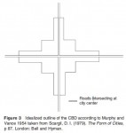
Evolution of the CBD
As the geographical concentration of commercial activity in the city, various CBD forms have been recognizable since at least the end of the eighteenth century. However, the manner in which the CBD functions is medieval as the linkages within the core area often need to be accessible by foot, which places an upper limit on the distance between functions that […]
Defining the Central Business District
This core frame spatial organization is also evident in non Western cities like Cape Town where the CBD is flanked by industrial parks in the southern suburbs of Claremont, Rondebosch, and Wynberg. Similarly, in UK cities other activities requiring less relative centrality, including court houses and libraries, are located toward the edge of the core while functional nodes make up the surrounding […]
Central Business District
The central business district (CBD) is that part of the city which contains the principal commercial streets and main public buildings. Throughout history the CBD has been characterized by a number of land use changes that include industrial, residential, commercial, administration, and consumption. These spatial and temporal changes have been used to support and reject a number of theories and delimitations […]
Techniques and Examples
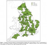
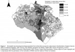
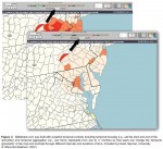
By far the most widely used cartographic representation of census data is the choropleth, or shaded area, map. The example provided in Figure 1 shows the 2001 census percentage of white ethnic groups in the city of Southampton, England. Values in the map are based on the aggregation of all the individual census results within each output area, clearly revealing […]
The Role of Census Mapping
Modern census organization involves the coordination of a very large workforce and geographical information systems (GISs) are routinely used to manage the logistics of enumeration. This organizational mapping does not generally form part of published outputs but nevertheless underpins the operational success of the census. Successful geocoding of individual census returns, linking them to the appropriate areas, is essential if counts […]
The Place of Censuses
Censuses of population play an important part in the government of nations, particularly with regard to the spatial allocation of resources. The earliest modern censuses, from which results have been widely published, can be dated from around the start of the nineteenth century, with the first census of population in 1790 in the US and 1801 in England and Wales. Censuses […]
Census Mapping
Census mapping refers to the cartographic presentation of the results of censuses in order to reveal spatial patterns in the data. Despite difficulties in achieving complete enumeration, the high population coverage of censuses means that it is usually possible to obtain data for very small geographical areas which can form the basis for detailed maps. Censuses are usually administered […]
Applications
A vast range of demographic, socioeconomic, and related analyses are based on census data, and those mentioned here are only indicative. In the past, census data were accessed through published volumes, but currently digital outputs predominate, ranging from online tabulations to customized data runs and the use of data labs. Data labs allow analysis down to the level of individual records, usually […]
Data and Geography Encoding
The historical development of the post enumeration processes of a census may be conceived in stages as shown in Table 1. Although the US census used some computer processing in 1950 (UNIVAC 1), most census data before the 1960s were manually encoded. Census agencies tended to adopt new computer technologies soon after they became available, and in some cases were significant contributors […]
Politics of Classification: Ethnicity and Religion
Two of the most contentious of census variables are race/ethnicity and religion. On one level, this relates to the perception that these are private and sensitive issues, and many censuses present a question on religion as optional. More fundamentally, especially in the case of ethnicity, the politics of classification are significant, since 'ethnicity' is a term incorporating aspects of […]
Geographies and Politics of Households and Family
Although households have served as one of the two basic units of census enumeration, they represent a complex series of debates within the social science literature. In Progress in Human Geography there has been an ongoing debate about the pivotal role of the household in shaping the geographies of gender, home, and everyday life. For example, studies of urban gentrification and […]
Population Coverage and Undercount
Although the ideal of census agencies is a 100% enumeration, most censuses fall short of that, and the rate of response is partly dependent on whether a census is compulsory or not. Although participation in the census in most countries is in theory compulsory, in reality it is not always possible to enforce. In the United States census of 2000, […]
Census Enumeration and Analysis
Although enumeration and analysis are generally considered as separate stages of the census process, technological changes have resulted in the boundaries between these processes becoming blurred since many of the same issues are found in both. The basic units of enumeration of most population censuses are the individual and the household. These are also the most common units of census […]
Census Implementation
History of Census Taking It is not known when the first census was taken, but there is evidence of census taking nearly 6000 years ago, with occurrences recorded in Egypt, China, Babylonia, Palestine, and Rome. Early censuses were undertaken especially for the purpose of military conscription, but were also used for purposes of taxation and labor requirements of […]
Census Geography
This article adopts a broader definition of census geography than is sometimes used. The more narrow definition, often used by statistical agencies, focuses on the spatiality of census taking and analysis, whereas this article also considers issues of census implementation and the techniques used by geographers and others in census analysis as well as the applications to which census data are […]
The Future for Cellular Automata in Geographic Research
Research work in this area is focused on a broad range of interests. Development of new applications is still quite active, with new cellular automata models popping up for a variety of phenomena of geographic interest, with an associated growth in their use as test beds for theory, practice, and policy. Researchers have also begun to focus on extending the basic […]
Geographic Applications in Other Sciences
Cellular automata have also been used in a variety of social science applications outside the geographic sciences, largely due to their value in representing geography in simulation. Cellular automata with fundamental space–time representations have been used in anthropology, to model the formation of societies and in political science and sociology to explore civil violence. Cellular automata have been […]
Human Geography Applications
Cellular automata have been employed in the study of a wide range of geographic phenomena. The plethora of applications is illustrative of the usefulness of the approach. Human geography applications are largely focused on issues relating to urban geography and behavioral geography. Models of urbanization and urban growth feature prominently in the literature. Cells are generally used to represent areas […]
The Advantages of Cellular Automata Modeling in the Geographic Sciences
Cellular automata have many advantages for geographic modeling. They are capable of supporting very large parameter spaces for simulation. A one dimensional CA with a binary state set and 13 cells has 213 possible configurations. A two dimensional version of the same CA has 2169 possible configurations, and a three-dimensional CA with the same specification has 22197! If we were to […]
Cellular Automata: A Primer
Automata are, fundamentally, computing media. Their origins date to Turing's work on computable numbers in the 1930s. Examples from the computer sciences include finite state machines, Turing machines, and artificial neural networks. These basic computing automata may be characterized as follows: where A represents an automaton, characterized by states S and a transition rule R. The transition rule functions to manage changes […]
Cellular Automata
Application of cellular automata to the study of geographical phenomena dates to the late 1960s and development of land use change models by Chapin and Weiss. While famous today for the invocation of Tobler's first law, a short paper on urban growth modeling by Waldo Tobler in 1970 is among the earliest examples of geographers' use of cellular […]

Capitalist Processes in the Making
Creation and Circulation of Capital Within the contemporary world economy, the dominant sets of relationships are increasingly capitalist in nature. Further, through rapid globalization a globalizing capitalist economy is emerging. This landscape means abstract understanding of capitalism can be deployed to, first, understand the relational basis of capital's existence and the pressures for particular behaviors that spring from crucial interactions […]

Contesting Abstractions
Neoclassical Economics In the abstractions of neoclassical economics, exchange is regarded as equivalent in and amongst all commodity markets, including the labor market. Consumers and producers have equivalent status as markets are paramount. The general structure of commodity exchange in terms of prices and relationships involving price is regarded as sufficient to characterize the whole economy. Buyers and sellers freely enter […]
Trying to Understand a Changing World
Academic interest in capitalism as a category of social organization stems from attempts to summarize how peoples at different times and places in history have sought to organize activities aimed at ensuring their survival, reproduction, and prosperity when faced with uneven availability of and access to resources. Categories such as capitalism both derive from and encourage politically laden questions either indirectly by […]
Capitalism
You are invited to ask the next person you meet after reading this article what they understand capitalism to be. Chances are, you will be quite shocked. In most peoples eyes capitalism is a dangerous word. The freight of politics past and present makes it a very sticky word. It carries so many negative connotations and imaginaries that to say the […]
Large Corporations, Political Regulation, Fordism, Mass Production, and Economies of Scale
In the last quarter of the nineteenth-century, the control and direction of large areas of industry came increasingly into the hands of banks and financiers. This era has thus come to be dominated by finance capitalism, characterized by the growth of large corporations – some of them developing into mammoth industrial cartels. The development of increasingly complex systems of […]
Geographies of Modern Capitalism
Though progress has been neither uninterrupted nor straightforward, the period since the last quarter of the nineteenth-century has seen the global triumph of capitalism. Indeed, the pace of change accelerated markedly during the twentieth century: the transformation of Western economies and societies that occurred during the 1900s as a result of immense technological advances is utterly without precedent. But there have […]
Geographies of Early Capitalism
Within the context of the theoretical and conceptual ideas outlined so far, it is now appropriate to examine the historical development of the capitalist system and the division of labor in the period since the late Medieval decline of feudalism. From Feudalism to Capitalism Though the term itself was coined only in the seventeenth century, feudalism describes a range […]

Theoretical and Conceptual Ideas
The Human Imperative to 'Truck, Barter, and Exchange' Among many writers who have offered theoretical explanations for the workings of capitalism, the first was Adam Smith, the Scots born philosopher and historian. Largely as a result of his 1776 book, An Inquiry into the Nature and Causes of the Wealth of Nations, Smith is regarded as the intellectual father of […]
Capitalism and Division of Labor
Capitalism is a socioeconomic system in which goods and services are produced for profitable exchange in a free market. The means of production are mostly in private ownership. As capital is accumulated, it is reinvested in further production. Investment decisions are usually made privately, and production and distribution are mainly controlled by independent companies that operate in competition with each other. The […]
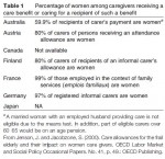
Toward an Inclusive Geography of Care and Caregiving
In this short article, we examined the dynamic and changing geographies of care and caregiving. This field of study evolved out of the combination of subdisciplinary developments in medical/health geography, and out of broader concerns for the implications of changes in healthcare policy and practice in Western developed countries. We reviewed the diverse set of theories and concepts that inform geographical approaches […]
Places and Spaces of Care and Caregiving
There is a growing body of work that explores the meanings and experiences of care and caregiving in various settings including healthcare institutions, communities, homes, and the body. The characteristics, meanings, and experiences associated with these four spaces of care and caregiving affect the organization and delivery of care, and the relationships, experiences, and practices involved in providing and receiving care. […]
Theorizing and Conceptualizing Care and Caregiving
Within geography, a central concern has been to elucidate the spatial manifestations and characteristics of care and caregiving in people's everyday lives with the explicit purpose of challenging taken for granted assumptions within prevailing health policies and practices. There are, however, many different and often contested ways to think about care and caregiving, and main contributions have come from, among others, […]
Geographies of Care and Caregiving
The importance of care and caregiving as a field of study can be understood as part of the general shift toward greater emphasis on the social aspects of healthcare, and as part of the response within the social sciences to broader changes in contemporary health policy and practice in Western developed countries such as Canada, New Zealand, and the United Kingdom. […]
Care/Caregiving
Care and caregiving involves a diverse and complex web of interventions, relations, and practices that occur between people in various traditional and nontraditional health and social care settings – all of which are intrinsically geographical. In this article, we examine geographical contributions to understanding care and caregiving beginning with a review of its roots within human/health geography with specific […]
Problems and Limitations of Animation
Beyond the problem of split attention mentioned above, psychologist Barbara Tversky and her colleagues have identified four major challenges when people watch and learn from animated graphics (including maps) as compared to the static graphics of the same data: Attention: In any visually rich display, especially in an animated map where many things can be happening simultaneously, readers are often […]
Nontemporal Animated Maps
Animated maps do not have to depict temporal data. One kind of a nontemporal animated map is a fly over map that simulates the experience of 'flying' over a digital landscape or zooming into or away from a location (as is possible with Google Earth). Most often with fly overs the map itself is static (e.g., the colors of the […]
Temporal Re-Expression, Filtering, and Interpolation
Although the most obvious way to animate spatiotemporal data is to simply play the data in the same sequence as it was collected (e.g., day 1 – frame 1, day 2 – frame 2, and so on), this is not always very insightful because: (1) the data may be very complex and contain multiple meaningful patterns, and/or (2) the […]
Temporal Animated Maps
Static maps present all of their information simultaneously; animated maps present information over time. Thus, animated maps have an additional representational dimension that can be used to display information. While it obviously takes time for a reader to scan a paper map, such as retrieving specific rates, the overall or holistic impression of the map happens at a glance. Moreover, […]