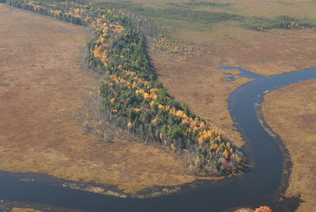
esker
AN ESKER IS A LONG, narrow, often snakelike ridge of sand and gravel deposited on top of the ground where a glacier has retreated. Eskers often follow valleys and lowlands, although some can go uphill. Most eskers are a single ridge, but there are also braided ridges, which are similar in shape to river tributaries. The esker got its name from an Irish Gaelic word, eiscir, which means “ridge of gravel.” If they are viewed from the air, eskers stand out from the rest of the terrain. They often look like large railroad embankments. Eskers are made up of all sizes of fluvial materials, from fine grains of sand to boulders. Most material, though, is the size of gravel. The finer sediments are often found near the top of the esker, while the large boulders will be much deeper. Eskers usually have steep sides of 25–30 degrees.
Most eskers formed during the time when glaciers were melting and retreating. A tunnel formed in the ice within the glacier, and meltwater began to run through the tunnel like an underground river. The water carried sediment with it. As it slowed down in certain places, some of the sediment was dropped and began to fill up the tunnel. As the tunnel filled up, the pressure of the water eroded the ice above it to make room for the water to continue flowing. Therefore, the whole tunnel seldom filled with sediment. When the glacier melted, the sediment in the tunnel was lowered to the ground. It followed the route of the underground river, which was usually perpendicular to the face of the glacier.
Most eskers formed in enclosed tunnels through which water flowed, but a few formed in ice-walled trenches that were open to the sky. Only in the channels that were closed by ceilings was the water able to flow uphill. This worked like water under pressure in the pipes of a water system. In the ice channels on top of the glacier, the sediment was let down to ground level as the glacier melted. Eskers range from a few meters high to over 250 ft (200 m) high. However, most are 100 ft (30 m) or less. Some are a few miles long, and others can be as long as 311 mi (500 km). Scientists believe that a very long esker probably did not form as one event but is made up of many individual eskers formed together during the retreat of the ice sheet.
Most eskers consist of a long, continuous ridge, but some have breaks in them. This happened because in some places, if the water was flowing more quickly, no sediment was deposited. Sediment was laid down when the speed of the water slowed down. Some eskers are known as “beaded eskers.” They have a regular pattern of narrowing and widening out. This is believed to have been due to the fact that more sediment was deposited in summer than in winter.
Through the years, eskers have served several purposes. Since they are raised above the surrounding terrain and are often more firm than the land around them, they have been used as road beds. In IRELAND, the Eiscir Riada is still used as the base of Highway N4/NM6 from Dublin to Galway. The land around it is boggy, so the esker provides a firm foundation for the road. In the wilderness, wildlife typically use eskers as travel routes. Eskers have also been used as graveyards and golf courses. Recently, prospectors have used eskers to predict where diamonds will occur. Bush pilots flying over the Canadian wilderness often use eskers to guide them. The largest eskers in the world are found in the Canadian provinces of Nunavut, Manitoba, Quebec, and Labrador.
Many eskers have entirely disappeared, though, because the gravel that made up the esker has been excavated and used to build roads. Where a gravel pit has been dug in an esker, scientists are able to study the internal structure of the esker.