Nicaragua
Area 49,998 square mi (129,494 square km)
Population 6.014 million 2014
Capital Managua
Highest Point 7,998 ft (2,438 m)
Lowest Point 0 m
GDP $11.81 billion 2014
Primary Natural Resources gold, silver, cooper, tungsten, lead, zinc.
BORDERED by COSTA RICA and HONDURAS, Nicaragua is the largest country in Central America. The country is divided into three distinctive geographical regions: the Pacific Lowlands, the North-Central Mountains and the Caribbean Lowlands (also known as the MOSQUITO COAST). The Pacific Lowlands is a narrow strip of highly fertile land that is composed of approximately 40 volcanoes. North-Central is mountainous, but the northwestern part of the country includes RAINFOREST. Beyond the western mountain range, the western coast is lined with savannas.
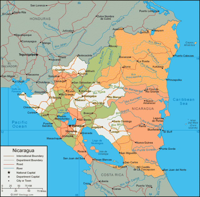
Eastern Nicaragua is bordered by rainforest, lagoons, and swamps, and tropical diseases are common. Two large freshwater lakes, Lake Nicaragua (Lago de Nicaragua) and Lake Managua (Lago de Managua), dominate the southwestern landscape. Lake Nicaragua, which is the more southern of the two large lakes, is the largest freshwater body in Central America. Approximately 20 percent of Nicaragua is arable.
Nicaragua is prone to severe earthquakes, volcanic eruptions and particularly hurricanes. Hurricane Mitch, which struck the Atlantic coast in 1998, devastated the country, killing some 10,000 people, causing catastrophic mudslides, and destroying many bridges and roads. The country has also suffered several volcanic eruptions and a major earthquake since the hurricane, which has made the country slow to recover its economy.
Nicaragua's climate is tropical. The western part of the country is hotter and drier and experiences a rainy season between May and November. The Eastern region is rainy nine months of the year and is subject to hurricanes. Nicaragua's key environment concerns are deforestation, soil erosion, and water pollution.
Among Nicaragua's earliest settlers were the Aztec people, who migrated down from the Mexican lowlands during the 10th century. The Aztec culture remains an influence today. Christopher Columbus is believed to be the first European to see Nicaragua, when he stumbled across the land during an expedition in 1502. The first European settlers were a Spanish exploratory mission that reached the southern shores of Lake Nicaragua around 1522. Nicaragua became a Spanish colony and remained so until gaining its independence from Spain in 1821. Nicaragua officially became an independent republic in 1838. After its independence, the country was headed by several conservative regimes. In 1934, it fell under the power of a repressive military regime, which held power until 1979, when the Sandinista rebel forces overthrew the military. The country held its first democratic elections in 1994.
Local governance of Nicaragua is divided into 15 administrative departments and two autonomous regions. The autonomous regions are Atlantico Norte and Atlantico Sur. The administrative departments are Boaco, Carazo, Chinadega, Chontales, Esteli, Granada, Jinotea, Leon, Madriz, Managua, Masaya, Matagalpa, Nueva Segovia, Rio San Juan, and Rivas.
Nicaragua is a developing nation. The country is a significant producer of cotton and coffee. There are also moderate gold and copper mining industries located in Nicaragua. However, an estimated 50 percent of the Nicaraguan population lives below the poverty level.