Ontario, Lake
LAKE ONTARIO, BORDERED by the UNITED STATES (NEW YORK state) and CANADA (province of Ontario), is the smallest and easternmost of the five Great Lakes, covering an area of 7,320 square mi (18,960 square km). It is 193 mi (311 km) long and 53 mi (85 km) wide, with a shoreline of approximately 480 mi (772 km). It lies 243 ft (74 m) above sea level, the lowest of any of the Great Lakes, while its deepest point is 802 ft (244 m) below the surface. Because its depth serves as a thermal reservoir, Lake Ontario does not freeze in winter except along the shore where the water is shallow. The surface is cool in the summer and warm in winter, and serves to moderate the climate of the surrounding land.
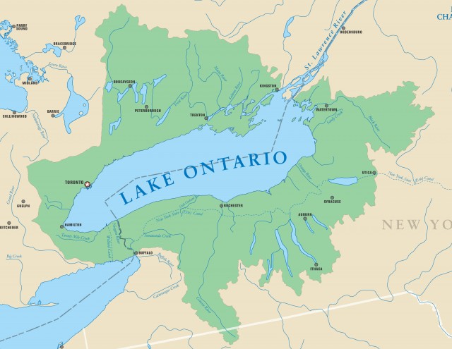
Water comes into Lake Ontario from Lake ERIE by means of the Niagara River and the Welland Canal, which was built to bypass the famous Niagara Falls. Other rivers flowing into Lake Ontario include the Black, Genesee, Oswego, Trent, and Humber. The Genesee and Oswego rivers, combined with the Erie Canal, allow ship traffic to pass from Lake Ontario to the Hudson River, which leads to NEW YORK CITY. Lake Ontario empties into the ATLANTIC OCEAN via the St. Lawrence River.

The lake has long enjoyed an important status for shipping, and the oldest U.S. lighthouse on the Great Lakes was built at Fort Niagara, just beyond the falls, in 1818 to aid in navigation. Lake Ontario boasts many excellent harbors, and their economic importance has only increased since the completion of the St. Lawrence Seaway made it possible to transport goods by water from any of the Great Lakes to the Atlantic Ocean. On the U.S. side of Lake Ontario, Rochester and Oswego are located in New York state. Canada has Coburg, Toronto, Hamilton, and Kingston. Toronto, capital of the province of Ontario, is the largest city on the shores of Lake Ontario.
Beyond these cities, the shoreline is still primarily rural. Although there are excellent orchards all around the lake, the region is not intensively farmed. However, there is enough runoff from the agricultural regions to exacerbate the pollution load coming from industrial cities upstream. Because Lake Ontario is the last of the Great Lakes, pollutants from all the other four lakes flow through it on their way to the Atlantic Ocean, making it the most polluted of the Great Lakes.
Lake Ontario has seen some commercial fishing, particularly of eels. Large numbers of eels have historically been harvested from Lake Ontario, but eel populations have recently declined to the point that some scientists believe the population may vanish altogether. Ironically, the destruction of eel stocks became a vicious cycle as scarcity drove prices up, making it worthwhile for commercial fishing concerns to go to greater lengths to harvest them.
Excellent state and provincial parks on its shores make Lake Ontario a very popular tourist destination. It boasts excellent sport fishing and hunting, although industrial pollution has made it medically risky for sports fishermen to actually eat their catch. Guidelines generally suggest that an adult should consume wildcaught Lake Ontario fish no more than once a month and that children and pregnant women should not consume any at all.
Geologists believe that Lake Ontario was created as the result of glacial erosion and that it is the remnant of a much larger lake they call Lake Iroquois for the Native American people who lived in the area. The shrinkage of Lake Iroquois into modern Lake Ontario left behind sediments that make for a very rich horticultural region. Lake Ontario was originally named Lake St. Louis in 1632 by the French explorer Samuel de Champlain. This name appeared on maps as late as 1656, but in 1660, Francis Creuxius gave it the name of Ontario, from an Iroquois word meaning “beautiful lake.”