Azerbaijan
Area 53,820 square mi (86,600 square km)
Population 9.538 million 2014
Capital Baku
Highest Point 15,551 ft (4,740 m)
Lowest Point Caspian Sea -92 ft (-28 m)
GDP $75.20 billion 2014
Primary Natural Resources petroleum, natural gas.
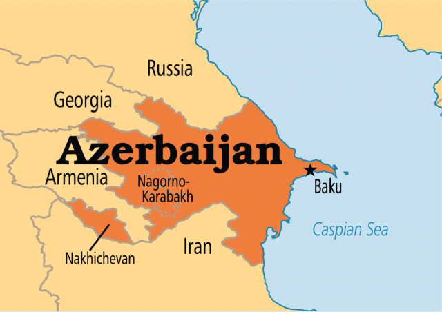
AZERBAIJAN, A FORMER Soviet republic, now officially the Republic of Azerbaijan, is a nation with a Turkic and majority Muslim population. It regained independence after the collapse of the Soviet Union in 1991. It is located in the region of the SOUTHERN CAUCASUS MOUNTAINS, and borders the CASPIAN SEA to the east, GEORGIA and RUSSIA to the north, IRAN to the south, and ARMENIA to the southwest and west. A landlocked nation, Azerbaijan has three dominant physical features: the Caspian Sea, whose shoreline forms a natural boundary to the east; the Greater Caucasus Mountain range to the north; and the extensive flatlands at the country's center. Of the three Transcaucasian states (Georgia, Armenia, and Azerbaijan), Azerbaijan has the greatest land area. A small part of Nakhichevan also borders TURKEY to the northwest. The capital is the ancient city of Baku, which has the largest and best harbor on the Caspian Sea and has long been the center of the republic's oil industry.
The country's elevation changes over a relatively short distance from lowlands to highlands; nearly half the country is considered mountainous. Notable physical features are the gently undulating hills of the subtropical southeastern coast, which are covered with tea plantations, orange groves, and lemon groves; numerous mud volcanoes and mineral springs in the ravines of Kobustan Mountain near Baku; and coastal terrain that lies as much as 92 ft (28 m) below sea level. Except for its eastern Caspian shoreline and some areas bordering Georgia and Iran, Azerbaijan is ringed by mountains. To the northeast, bordering Russia's Dagestan Autonomous Republic, is the Greater Caucasus range; to the west, bordering Armenia, is the Lesser Caucasus range.
To the extreme southeast, the Talysh Mountains form part of the border with Iran. The highest elevations occur in the Greater Caucasus, where Mount Bazar-dyuzi rises 15,551 ft (4,740 m) above sea level. Eight large rivers flow down from the Caucasus ranges into the central Kura-Aras lowlands, alluvial flatlands, and low DELTA areas along the seacoast, designated by the Azerbaijani name for the Mtkvari River and its main tributary, the Aras. The Mtkvari, the longest river in the Caucasus region, forms the delta and drains into the Caspian a short distance downstream from the confluence with the Aras.
Partly because of the great range of altitude in the country, there is a variety of climate, vegetation, and soil conditions. Climate varies from subtropical and dry in central and eastern Azerbaijan to subtropical and humid in the southeast, temperate along the shores of the Caspian Sea, and cold at the higher mountain elevations. Because most of Azerbaijan receives scant rainfall—on average 5.9 to 10 in (15.2 to 25.4 cm) annually—agricultural areas require irrigation.
Azerbaijan shares all the formidable problems of the former Soviet republics in making the transition from a command to a market economy, but its considerable energy resources brighten its long-term prospects. A continuing conflict with Armenia over the Nagorno-Karabakh region may be an obstacle to economic growth.