orographic precipitation
OROGRAPHIC PRECIPITATION is caused or enhanced by one or more of the effects of mountains on the Earth's atmosphere. These effects include the upward or lateral motions of air directly caused by mountains acting as a barrier as well as the thermal effects of the mountains that cause them to be elevated heat or cold sources. Mountains can generate both stratiform precipitation, which takes place in a statically stable atmosphere, and convective precipitation, which results from the release of static instability.
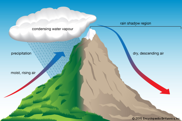
The most obvious effect of mountains is that they can cause the air encountering them to rise. Rising air cools adiabatically, and if it is sufficiently humid, condensation and perhaps precipitation can occur. Precipitation formed by this mechanism is widely referred to as upslope precipitation. It is widely recognized that the slope on the upwind side of the prevailing wind (the windward side) generally receives more precipitation than the leeward side. In contrast, some of the world's deserts are on the leeward side of mountain ranges. Because of interactions with other processes, however, there is no general rule about the location on the mountain slope where the maximum upslope precipitation will occur.
SEEDER-FEEDER
Upslope precipitation may be enhanced by the seederfeeder mechanism. A low-level stratus cloud (feeder cloud) forms near the top of a mountain. Its temperature is below freezing but warm enough so that it lacks ice nuclei. Ice crystals fall from a higher (and colder) seeder cloud into the feeder cloud. These ice crystals grow at the expense of the water droplets in the feeder cloud by the Bergeron process. The large ice crystals then precipitate out of the feeder cloud to the Earth's surface. This process increases the precipitation efficiency of the feeder cloud because the moisture from small water droplets, which otherwise would not have reached the Earth's surface, evaporates and is deposited on the ice crystals.
Mountains can generate precipitation through the release of static instability by providing a lifting mechanism for air parcels as well as by orographic processes that destabilize the air column. Precipitation can be generated by three categories of processes: orographic lifting, thermal effects, and obstacle effects. Orographic lifting can bring air to the Level of Free Convection (i.e., the level at which it becomes positively buoyant). If the atmosphere has a sufficiently thick layer above this level that is statically unstable, precipitation may result. Lifting of an air column can cause it to become more statically unstable.
The thermal effects of mountains occur because orographic features can serve as elevated heat or cold sources. During the day, the sun heats the mountain slope. It warms the air next to it, which then becomes warmer than the atmosphere at the same elevation away from the mountain over lower land. Thus, there is low pressure next to the mountain toward which the air moves—producing upslope flow. This heating can be modified by surface conditions. Bare rock will transfer more sensible heat to the atmosphere than snow cover. At night the mountain surface cools, which causes the air above it to cool and results in air that flows down the slopes. Air moving across the mountain top during the day is heated by the mountain. This heating helps to destabilize the air column.
In addition, convergence (which promotes upward air motion) may be produced at the ridge crest as air flows up the slope from opposite directions. The combination of the heating and the heating-induced convergence can generate thunderstorms. At night, downslope winds from mountains on opposite sides of a valley can converge in the valley and encourage the generation of thunderstorms as well.
THERMAL EFFECTS
Mountain ranges and high plateaus can have largerscale thermal effects on precipitation. During the summer, heating causes low pressure to form near the surface over high elevation areas. Convergence into this low pressure area can encourage the formation of thunderstorms. Since heating is stronger during the day, the location of the lowest pressure varies diurnally. The changes in this location can affect the time of day that is most favorable for precipitation to form for a particular place in or near a mountainous region.
Mountains also act as obstacles to air flow and in so doing can encourage the development of convective precipitation. Convergence may be generated when air moves through a progressively narrower valley or when air moving around the mountain base arrives on the other side. These processes can cause moisture convergence as well and static stability is quite sensitive to atmospheric humidity.
Under stable static stability conditions, mountains may generate buoyancy waves—commonly known as gravity waves. These waves propagate downstream (and sometimes upstream as well) of the mountain. The parts of the wave that contain upward-moving air may aid in the development of convective storms, especially if they interact with other mountain-generated circulations such as the diurnal mountain-valley winds.
Orographic variations can contribute to the development of convective storms in their surrounding areas as well as in the mountainous area itself. As they interact with the large-scale wind field, mountains may generate downstream eddies in the flow under some conditions. An example of such an eddy is the so-called Denver cyclone. Such a cyclonic circulation can have areas of convergence and vorticity that encourage the development of convective storms. Outflow from thunderstorms generated within the mountains may initiate convective storms in the surrounding lowlands.