Planes, boats, skis
Despite the attention paid to the exceptions, much weather is a story of modest variation around the average. There are, however, times and places when the details are all-important.
Possibly the first profession to find this out were sailors, for whom the weather has long been a prime hazard. For most of history, too, the weather has been the engine powering most of the worlds shipping. The weather at sea is simplified by the absence of land, so the effects of air striking mountains or other land masses are removed. But the added complication is that the land usually stays still when the wind blows, while the sea reacts to the wind blowing across it.
The result is that sailors need ways of describing how much trouble they are in, and that cover both water and air. As long ago as 1805, the British admiral Sir Francis Beaufort developed a way of quantifying the wind that is now in use worldwide. Fie defined criteria for recognizing wind speeds both on land and at sea. His scale starts at 0, “calm”, characterized by smoke rising vertically from chimneys or, at sea, “sea like a mirror”, but soon reaches categories such as 7, “near gale”, with whole trees in motion on land and white foam being blown in streaks at sea. It concludes with 11, “violent storm” which is “accompanied by widespread damage” and, at sea, small and medium ships vanishing from view behind the waves, and finally 12, “hurricane”, which is simply worse than all the other grades, with wind speeds above 72mph. Note that in each case, more severe wind means more severe waves.
In addition, sailors need to know what they are looking at, since if their ability to see declines, so does their safety. “Fog” is defined as seeing a mile or less, “poor” visibility 1-3 miles, “fair” 3-6 miles and “good” anything better. When living came along, a new industry whose safety and ability to operate depended on the weather was created. In Britain, the Meteorological Office was for many decades more or less a front for the Royal Air Force, funded from the defence budget, much as the Army had the Ordnance Survey, which mapped the land.
Pilots have to worry about the general circulation of the atmosphere, to avoid flying into headwinds too often, but must also know about more immediate problems. One is seeing where they are going. Although radar and satellite navigation have ended the days when fog could ground all planes, pilots still like to know the “ceiling”, or the height of the base of continuous cloud cover, that they are flying into. The key distinction is between instrument meteorological conditions and visual meteorological conditions. If there is enough visibility, a pilot can land a plane by brain power, but if there is not, instruments are needed as well.
The most specific flying hazards posed by the weather arise from thunderstorms. Radar can spot them at a good distance, and it is possible to steer round modest ones. The most dangerous are large storms which can generate severe updrafts and downdrafts of over 1km a minute. Light aircraft are warned to avoid them by up to 20km because of their ability to spawn new storm cells. Other prime aviation hazards include “microbursts” of cold air hurtling straight down from a convecting cloud – just the thing as you are taking off or landing.
The other group who need some specialist knowledge of the weather includes anyone who spends serious time a long way above sea level without using an aeroplane. Mountains make their own weather, and it is usually less friendly than conditions down in the lowlands.
The first problem with mountains is that as you climb them, the temperature drops. A warm sunny day in the valley may be a cold, bright day 1000m up. That is fine if you are ready for it, but not if you have set off in the clothes that made sense at sea level. Many similar but slightly differing estimates are published for the average temperature drop with height. They average out at around 6°C per 1000m climbed, but that is an average and, especially in winter, temperatures can drop much faster than this. As well as an increased risk that you are going to get cold, this means that ice and snow can persist on mountains, especially in spots that get no direct sunshine, long after they have vanished elsewhere.
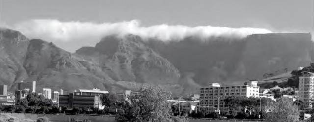
Next, the air itself has to climb as it hits the hills. This means snow and rain, but it also means cloud, as the air rises and cools and the water vapour it contains condenses. The classic case is Table Mountain in Cape Town, South Africa, where the “tablecloth” of cloud is a frequent sight on top of the hill. It looks lovely, but such cloud can be less welcome it you are having trouble finding your way down.
Nor are you completely safe away from the mountain tops. The air that does not find its way over the hills can be forced through a narrow valley instead, making for unexpectedly high winds.
On the up side, the distinctive weather of mountain areas is now the subject of a wealth of specialist forecasts designed to lessen the annual cull of walkers, climbers and skiers. Almost every mountain region has one and there is no excuse for not consulting it before you set out for the hills.