What Mechanisms Can Force Air to Rise?
AIR RISES FOR VARIOUS REASONS, some caused by differences in density between the air and its surroundings, and others a result of externally imposed factors, like a mountain. If an air parcel rises because atmospheric conditions are unstable, free convection results. If air is forced to rise due to external factors, it is called forced convection. Forced convection can occur in a number of settings, even if the atmospheric conditions are stable.
How Do Convergence and Divergence of Air Cause Rising?
As air moves laterally across the surface of the Earth and at higher levels, it can encounter obstacles that impede continued motion. Such obstacles can be mountains or other features on the land surface, or they can be other air masses moving in an opposing direction.
Convergence of Low-Level Air Masses
Low-level convergence occurs when winds from two systems are moving on a collision course. The easiest way for the colliding air to move is upward. In such cases, the air parcel must rise whether it is stable or unstable. If the air reaches its dew point as it ascends and cools, water vapor condenses into tiny drops that form clouds and perhaps precipitation.
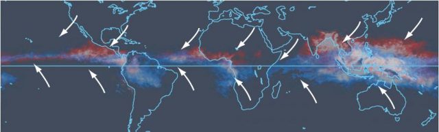
The best example of a location where low-level convergence is important at continental scales is the Intertropical Convergence Zone (ITCZ), which encircles the Earth, more or less centered on the equator. In the satellite image above, the ITCZ appears as the belt of moist air and clouds shown in red for its position during the northern summer and blue for its position during the southern summer. Along the ITCZ, the northeast trade winds, coming from north of the equator, converge with the southeast trade winds coming from south of the equator. The two sets of trade winds converge at the ITCZ, causing cloud cover as moist air is uplifted to a height at which it cools to its dew-point temperature.
Interaction of Moving Air with the Land Surface
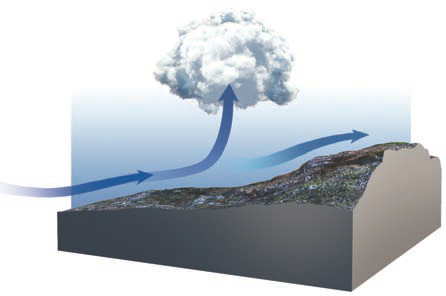
Low-level convergence also occurs by a wind that is slowed down, such as by friction with the surface. The slowed air causes faster moving air behind it to begin to pile up, forcing some air to rise. A common scenario for this involves a sea breeze, where winds blowing across a large water body slow down as they encounter the more irregular land surface.
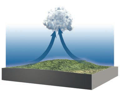
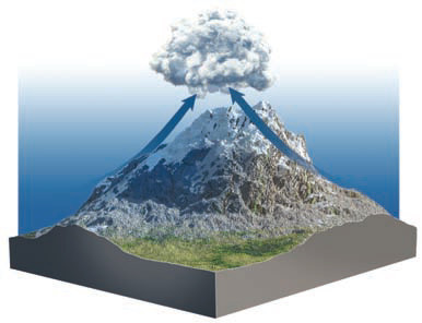
Mountainous areas represent obstructions to low-level winds. As air encounters topography, it slows down, piles up, and rises, called an orographic effect. As the air rises, it cools by adiabatic expansion, forming a cloud if it cools to the dew-point temperature. This orographic effect is why thunderstorms are usually more common over mountain peaks than over the adjacent valleys.
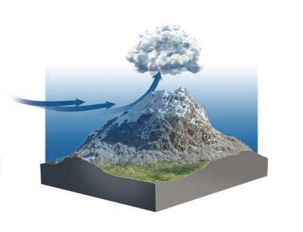
During daytime, the Sun heats the surface more efficiently than the air above it. As the surface of a mountain warms, the adjacent air warms, which then flows upslope. When winds flowing up opposite sides of the mountain converge at the summit, they rise more. This is yet another reason why cloud formation seems to occur preferentially over mountains.
Convergence and Divergence Caused by Rossby Waves
1. Convergence can also occur from the way that upper-level air circulates around bends in the polar front jet stream, as illustrated in the figure to the right. These bends in the jet stream are called Rossby waves.
2. In upper levels of the troposphere, air that turns around ridges of high pressure will tend to move slightly faster than air around low-pressure troughs. This is because air turning around ridges moves to the right in the Northern Hemisphere (as shown in this example), in the same rotation direction as the Coriolis effect. The two forces work together on this type of bend.
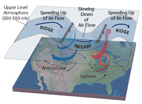
3. Around troughs, air turns to the left (in the Northern Hemisphere), in opposition to the Coriolis effect. Along these bends, the Coriolis effect works against the flow of air, and the air moves slightly more slowly.
4. The slowing down of air as it moves from the upper-level ridge of high pressure to the upper-level trough of low pressure causes air to converge aloft on the ridge-to-trough side of the Rossby wave. This piled-up air then sinks and warms adiabatically, causing high pressure near the surface.
5. On the opposite side of the trough, the air speeds up as it turns into the next ridge. This speeding up causes the air to diverge and spread apart. Air from below flows into this zone of divergence, causing low pressures near the surface. This promotes rising of the near-surface air. All of the directions of rotation shown here are opposite in the Southern Hemisphere.
How Do Mountains Affect Adiabatic Temperature Changes?
Mountains interact with moving air masses in interesting ways. In the example below, moist air encounters the side of a mountain and is forced to move upslope. Once it reaches the top, the air flows down the other side. Examine this setting and think about what happens to the air on its way up and on the way down.
1. As the air encounters the base of the mountain and begins moving up the slope, it is initially unsaturated and cools according to the unsaturated adiabatic lapse rate, which is 10 C°/km everywhere.
2. As the air flows upslope, at some elevation it has cooled enough that it becomes saturated (reaches the dew point), and at this level clouds form. This height is called the lifting condensation level. As this air continues rising, it now cools at the saturated adiabatic lapse rate, which is somewhat less than the unsaturated adiabatic rate.
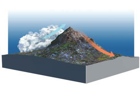
3. By the time the air reaches the top, it has been warmed by latent heat. As it moves down the other side it will compress and warm, and the air will become unsaturated (warm air has higher water-vapor capacity than cold air). It will remain unsaturated, thereby causing a drying effect on this side of the mountain. It warms according to the unsaturated adiabatic rate of 10 C°/km.
4. As a result of this process, the air at the leeward side will be warmer than the air at the same elevation on the windward side.
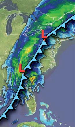
How Do Fronts Induce Rising Motion?
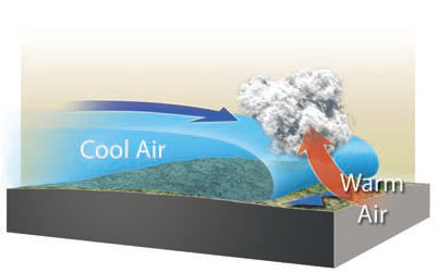
Whenever two air masses with significantly different temperatures meet, the warmer air will be forced up and over the colder air because the warm air is less dense. This process is called frontal lifting. As this warm air rises, it will cool adiabatically. If it has abundant moisture, it will not need to rise very high before it cools to the dew-point temperature. At that level, active condensation or deposition begins and a cloud forms. This can lead to precipitation, as shown by colors on this weather map near a weather front marked by the blue line. The teeth on the line indicate which way the front is moving. The weather associated with fronts is presented in the next chapter.