Assembling a Continental Desert
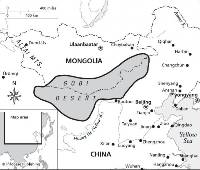
Almost unimaginable forces raised the vast network of surrounding mountain ranges that created the Gobi Desert. Understanding the creation of the Gobi requires an understanding of plate tectonics and the theory of continental drift. Geologists have discovered that the Earth's surface is divided into a series of crustal plates that include both heavier oceanic material and lighter continental material. These cooler and more solid surface parts of the Earth's rock crust move slowly over time across the hotter, weaker, underlying asthenosphere atop Earth's semimolten mantle. The mantle churns with great convection currents that well up against the bottom of this thin, cool, brittle layer of crustal rock. Those currents cause great cracks to form in the oceanic crust along the deep ocean ridges and trenches. Molten magma pushing up from the mantle constantly adds new rock to the oceanic plate margins, and the lighter rocks comprising the continents go along for the ride.

The story of the Gobi Desert really started 100 million years ago when movements of crustal plates began to assemble modern Asia. At that time, India was an island continent, much like present-day Australia. Previously, it had been part of a single, great supercontinent scientists have named Gondwanaland. The fragmented pieces of this supercontinent broke up and began to drift with the movements of the oceanic plates. At some point, as a result of still poorly understood changes deep in the Earth, the mass of light crustal rock that makes up India spun, shifted, and headed north at what rates as breakneck speed in geology. No one knows for sure why this rogue continent started scooting along three or four times as fast as any crustal plates are moving today. The leading theory suggests that the plate was being pulled from the north, where it was plunging in under the edge of Asia at the same time it was being pushed from the south by vigorous seafloor spreading along a mid-ocean ridge. Light continental rock usually does not get caught under the edge of a plate of dense, heavy seafloor rock. So once the leading edge of the plate got subducted under the edge of another plate, the heavy overlying rock drove it down quickly. Moreover, the plate might have split over a hot spot in the mantle where the deep currents drove superheated rock against the crust. As a result, the combined pull from the north and push from the south created a great, continental pileup.

This caused perhaps the most titanic geologic collision in history. Some 55 million years ago, India plowed into Asia. The edges of both continents were made of light rock, so instead of one going down under the other, they created a massive pileup. This created the Tibetan Plateau, an immense upland that forms the highest region on the planet, with an average elevation of 15,000 feet (5,000 m). It includes most of the world's highest mountains, including Mount Everest in the Himalayas. The Earth's crust is thicker here than anywhere else.