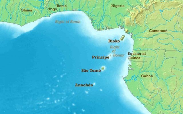
Bight of Benin
A “BIGHT” REFERS TO a bend or curve, most often a crescent shape, that forms an open bay in a coastline. The Bight of Benin is a roughly 500-mi- (800-km-) long bend in the West African coast, stretching from near the mouth of the Volta River (Cape Saint Paul) in GHANA eastward across the coastlines of TOGO and BENIN to the DELTA of the Niger River in NIGERIA. The Bight of Benin received its name from the centuries-old kingdom of Benin located in southern Nigeria. The nation of BENIN (formerly Dahomey) consequently received its name from the coastline in 1975.
The Bight of Benin is a region rich in culture and history. Prior to European colonization, major African kingdoms existed in the area, including the Asante (1750 to late 1800s) in what is now Ghana, Fon (1700s) and Dahomey kingdoms (1800s) in what is now Togo and Benin, and the Yoruba (1000s to 1800s) and Benin (1200s to 1897) kingdoms in what is now Nigeria.
Portuguese explorers, reaching the area in 1485, found the city of Benin to be as well organized as cities in Europe. Between 1500 and 1800, the Benin kingdom expanded power, largely through trade with the Portuguese. The tropical climate brought hardship to Europeans from disease and trying conditions. An old rhyme stated, “Beware, beware the Bight of Benin, for few come out though many go in.”

Also known as the Slave Coast, the region was an important area of slave trading from the 1500s to the 1800s. Some pre-European slavery was practiced, largely as prisoner labor resulting from wars among kingdoms. Slavery expanded with European contact, with mostly males sent abroad and females staying within Africa. The Dahomey kingdom became a major source of transatlantic slave trade to BRAZIL, the Caribbean, and the UNITED STATES. The kingdom was the origin of an estimated 14.5 percent of U.S. slaves. The cities of Abomey and Ouidah became international cultural and trading centers.
Many slaves spoke the Gbe language and practiced the religion of Vodun (a predecessor of Haitian voodoo). As many as 10,000 to 15,000 slaves were exported per year. By the early to mid-1700s, so many local slaves were exported that prices rose and other African regions to the west and south were exploited. King Duezo of Dahomey brought independence from the Yoruba in the early 1800s. Abolition of slavery in Brazil in 1880 brought liberated slaves back from Brazil. Many were skilled tradesmen who formed an upper class in Porto Novo and Lagos, bringing some Portuguese architecture that had been popular in colonial Brazil.
Palm oil then became the major regional export until petroleum oil was discovered in the Niger River delta in the 1950s. Cotton and cocoa are also major exports. The coastal population today includes the nations of Ghana (former British colony, 20 million), Togo (former German and French colony, 5 million), Benin (former French colony, 7 million), and Nigeria (former British colony, 130 million).
The Bight of Benin has a long dry season from November to the end of March, driven by northerly Harmattan winds. It has a first rainy season from April to July, a short dry period in August, and a second rainy season in September and October. Rainfall can exceed 10 in (25 cm) in June and 50 in (127 cm) annually. Average temperatures range from lows of 75 degrees F (23 degrees C) to highs of 85 degrees F (28 degrees C) in the wet season and 90 degrees F (32 degrees C) in the dry season.
Major ports include Lome (Togo), Cotonou (Benin), and Lagos (Nigeria). Ouidah was the only port in Benin until 1908. Ouidah today features a voodoo museum, the Sacred Forest, and Route of the Slaves, a short road with landmarks, statues, and villages along the route slaves took to the ships. North of Cotonou is Ganvie, a town of bamboo huts built on stilts for protection. Religious custom prevented Fon and Dahomey warriors from crossing into water. Much of the Bight of Benin coastline has white sand beaches, clear water, tidal flats, and coastal lagoons, accompanied by strong tides and currents.