Mauritania
Area 397,955 square mi (1,030,700 square km)
Population 3.970 million (2014)
Capital Nouakchott
Highest Point 2,985 ft (910 m )
Lowest Point 0 m
GDP $5.061 billion (2014)
Primary Natural Resources fish, iron ore, gypsum, copper, phosphates, salt.
MAURITANIA IS LOCATED in Northwest Africa on the coast of the ATLANTIC OCEAN. It covers an area slightly larger than TEXAS and NEW MEXICO combined. It is bordered on the northwest and north by WESTERN SAHARA, on the northeast by ALGERIA, on the east and southeast by MALI, on the southwest by SENEGAL, and on the west by the Atlantic Ocean. Mauritania has 435 mi (700 km) of ocean coastline, which is extremely rugged with no natural harbors and has waves of extraordinary height. The Senegal River forms the border with Senegal, helps to form an alluvial fan that supports agriculture in the area, and is Mauritania's most densely populated region.
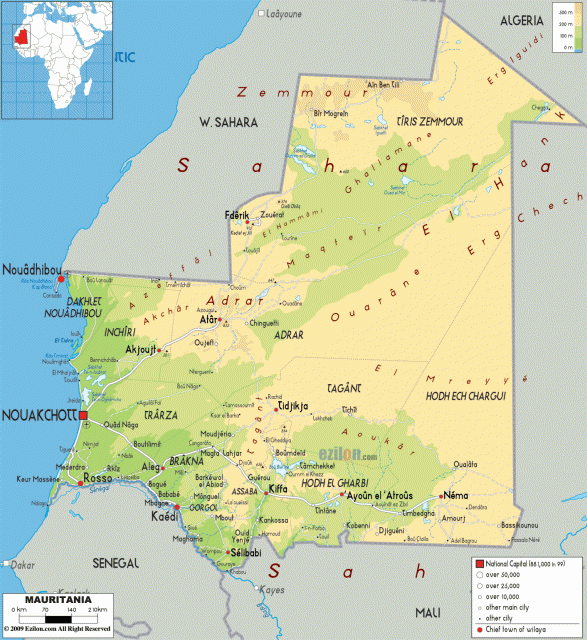
Two-thirds of Mauritania is covered with DESERT. The country lies entirely within the SAHARA DESERT which covers an area of 3,320,450 square mi (8,600,000 square km). The 17th parallel is the dividing line between the true desert to the north and the Sahelian zone made up mostly of savanna to the south. The desert has no vegetation in the eastern parts of Mauritania, but the western section closer to the Atlantic has some temporary pasturage for nomadic camel herders. This western section also has some oases, the largest being the town of Atar. The desert is dominated by wind, sand, and erosion. It has many shifting dunes in immense basins that are grouped into “ranges.” The only real elevation is an almost horizontal sandstone plateau rising 1,500 ft (460 m) that runs through the center of the country from north to south. There are also occasional buttes and steep rims covered in sand or sometimes pebbles.
The TROPIC OF CANCER crosses the northern half of the desert in Mauritania. In this area, there is a prevailing continental wind blowing year-round. Rainfall in this area amounts to less than 4 in (10 cm) per year, and when it does occur, rain is usually extremely violent and brief. To the south, in the Senegal valley, the area receives about 26 in (66 cm) of rain per year, mainly during the three or four months of summer. The temperature averages about 100 degrees F (37.8 degrees C) during the day in most of Mauritania and much cooler at night, sometimes down to near 32 degrees F (0 degrees C).
Mauritania gained its independence from FRANCE on November 28, 1960, and since then has been a constitutional republic. Soon after independence, Mauritania developed a modern mining industry. Miners found large deposits of high-grade iron ore in northern Mauritania and have since developed them for exporting. They also mine copper and salt in Mauritania. Most of the population, however, is busy raising crops or tending livestock in southern Mauritania. The ethnic groups that live in this area are mainly the Tukolor, Soninke, Bambara, and Wolof. The nomadic and seminomadic tribes of the Berber, Arab, Tuareg, and Fulani make up the majority of the population and range about Mauritania following their herds.