Western Sahara
Area 102,703 square mi (266,000 square km)
Population 261,794 (2014)
Capital None; occupied by Morocco
Highest Point 2,700 ft (823 m)
Lowest Point -180 ft (-55 m)
GDP per capita na
Primary Natural Resources phosphate.
AS OF 2005, WESTERN SAHARA, formerly called Spanish Sahara, was officially occupied by MOROCCO. Western Sahara is one of the most inhospitable places on earth. On average, it has only 2 in (5 cm) of rain a year. It is almost entirely a land of hot, dry, sandy and rocky desert with sparse vegetation. Western Sahara is about the size of Great Britain or COLORADO. It shares a border of 276 mi (444 km) with Morocco in the north, 19 mi (31 km) with ALGERIA in the northeast, and 976 mi (1,571 km) with MAURITANIA in the east and south. Western Sahara is the extreme western end of the SAHARA DESERT on the ATLANTIC OCEAN. The coastline is 660 mi (1,602 km) long. Much of the coastline is a wall of sheer cliffs. There are only a few natural harbors, while sand banks and shallow coastal waters make the coast dangerous. Along much of the coast is a narrow belt of sand dunes about 10 to 20 mi (16.1 to 32.2 km) wide. Most of the remainder of the country is windswept gravel plains.
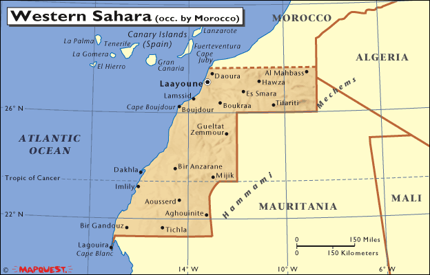
Western Sahara has two major regions. In the north is the Saguia El-Hamra region. It begins at the border with Morocco and extends south to an east-west line from Boujdour on the coast to the northern border with Mauritania. The Saguia El-Hamra region is named after the Seguia El-Hamra (the “Red River”) river valley. It is the only important river in the country, but its flow is mostly seasonal during the wet season. It flows east to west from its source in the Zemmour massif across the northern part of the country. What little water it carries flows into the Atlantic Ocean. There are several other rivers in Western Sahara, but all are seasonal with water only during the wet wintertime. In the Saugia El-Hamra region, the land rises gradually from the coastal sand dune belt to the east. It reaches it maximum height of around 1,300 ft (396 m) in the El-Gaada area in the northwest of the country. In the extreme northeast, the hammada is part of a gravel plain that extends deep into Algeria.
Western Sahara's southern region is the Rio de Oro. It occupies the southern two thirds of the country. The northern half of the Rio de Oro region is also the middle third of Western Sahara. It is flat desert from the coastal sand dunes until it meets the Zemmour massif in the east where it borders Mauritania. The Zemmour massif rises to 2,700 ft (823 m). The southern third of the Western Sahara, which is also the southern half of the Rio de Oro region, contains the plain of Tiris. In the extreme northeast of the southern third of the Rio de Oro is the Rio de Oro Bay where the port of Dakhia (Villa Cisnerous) is located. The coastal area south of Rio de Ora Bay is called the Aguerguer el Aatf. In the extreme south-central region of the Rio de Oro is the mountainous Adrar Soutouf, which has peaks of about 1,700 ft (518 m).
Western Sahara has desert winds. The worst is called the irifi, which is a sandstorm that blows out of Atlantic from the southeast. There are no significant oases in the Western Sahara. Most of the vegetation is shrubs or the occasional acacia tree. Most of the significant vegetation is in the Saguia el-Hamra and its tributaries. There are some rocky cisterns (guelta) where winter rainwater gathers.
The population of Western Sahara is small and largely nomadic. Most people are Arabs or Berbers; there are also a few Spaniards and Africans. The native people are Tauregs, Reguibat, Delim and the Izarguen. The people are today collectively called Saharawis.
The two most important cities are Laayoune (formerly El Aioun) located in the Sekia el Hamra zone, and Dakhla (formerly Villa Cisneros), on the Rio de Oro peninsula on the Atlantic coast.
After the discovery of rich phosphate and iron deposits in the 1960s, Morocco and Mauritania pressed historic claims to the area. However, native Saharawis organized a war of liberation to counter these claims. Calling themselves the Popular Front for the Liberation of the Sekia el Hamra and Rio de Oro or “Polisario,” they forced Mauritania to withdraw. Morocco currently administers the country, but the Polisario controls most of it.