Tectonic Landforms
There are two basic forms of tectonic activity: compression and extension.
Compression occurs when lithospheric plates are squeezed together along converging lithospheric plate boundaries, while extension happens along continental and oceanic rifting, where plates are being pulled apart.
FOLD BELTS
Let's start by looking at folding produced by compression. When two continental lithospheric plates collide, the plates are squeezed together at the boundary. The crust crumples, creating folds. The Jura Mountains of France and Switzerland, shown in Figure 12.19, are an example of relatively young—geologically speaking—open folds. The folds create a set of alternating anticlines, or up-arching bends, and troughs, called synclines.
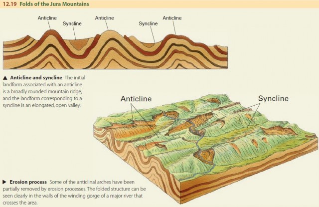
When fold belts are eroded, they create a ridge-and-valley landscape, like the eastern side of the Appalachian Mountains from Pennsylvania to Alabama. In this landscape, weaker formations such as shale and limestone are eroded away, leaving hard strata, such as sandstone or quartzite, to stand in bold relief as long, narrow ridges. These folds are continuous and even-crested, producing almost parallel ridges. In some regions, however, the fold crests plunge, rising up in places and dipping down in others. This provides a pattern of curving mountain crests and valleys.
Note that anticlines are not always ridges. If a resistant rock type at the center of the anticline is eroded through to reveal softer rocks underneath, an anticlinal valley may form. A synclinal mountain is also possible. It occurs when a resistant rock type is exposed at the center of a syncline, and the rock forms a ridge.
FAULTS AND FAULT LANDFORMS
A fault is a fracture created in the brittle rocks of the Earth's crust, as different parts of the crust move in different directions. Fault lines can sometimes be followed along the ground for many kilometers. Most major faults extend down into the crust for at least several kilometers.
Faults are evidence of relative movement between the rock on either side of the fault. Rock on either side suddenly slips along the fault plane, generating earthquakes. A single fault movement can cause slippage of as little as a centimeter or as much as 15 m (about 50 ft).
These movements typically happen many years or decades apart, or even several centuries apart. But when we add up all these small motions over long time spans, they can amount to tens or hundreds of kilometers. There are four main types of faults: normal, transcurrent, reverse, and overthrust faults.
Normal faults are a common type of fault produced by crustal rifting. They usually occur as a set of parallel faults creating fault scarps, grabens, and horsts. Where normal faulting occurs on a grand scale, it produces ranges of block mountains flanked by downdropped lowland basins.
When lithospheric plates slide past one another horizontally along major transform faults, we refer to these faults as transcurrent faults, or strike-slip faults. The San Andreas fault is a famous active transcurrent fault.
You can follow it for about 1000 km (about 600 mi) from the Gulf of California to Cape Mendocino.
Throughout many kilometers of its length, the San Andreas fault appears as a straight, narrow scar. In some places this scar is a trench-like feature, and elsewhere it is a low scarp.
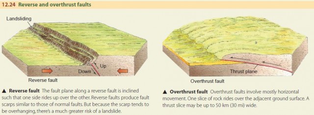
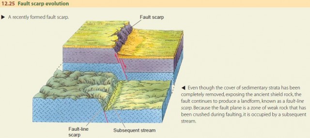
Figure 12.24 illustrates the reverse fault and the overthrust fault. Both are caused by crustal compression. The San Fernando, California, earthquake of 1971 was generated by slippage on a reverse fault. When compression is severe, for example, in a continent-continent collision, rock layers can ride over each other on a low-angle overthrust fault. Repeated faulting can produce a great rock cliff hundreds of meters high. Because fault planes extend hundreds of meters down into the bedrock, their landforms can persist even after several million years of erosion. Figure 12.25 diagrams the effect of erosion on a fault scarp.
THE EAST AFRICAN RIFT VALLEY SYSTEM
The Rift Valley of East Africa provides an example of extension and normal faulting at a continental scale. Here, continental lithosphere is beginning to rupture and split apart in the first stage of forming a new ocean basin. The Rift Valley is basically a series of linked and branching grabens, but with a more complex history that includes building volcanoes on the graben floor.
Figure 12.26 shows a map of the East African Rift Valley system. It is about 3000 km (1900 mi) long and extends from the Red Sea southward to Lake Nyassa. Along this axis, the Earth's crust is being lifted and spread apart. The rift valleys are like keystone blocks of a masonry arch that have slipped down between neighboring blocks because the arch has spread apart somewhat. Thus, the floors of the rift valleys are above the elevation of most of the African continental surface. Major rivers and several long, deep lakes—Lake Nyassa and Lake Turkana, for example—occupy some of the valley floors.
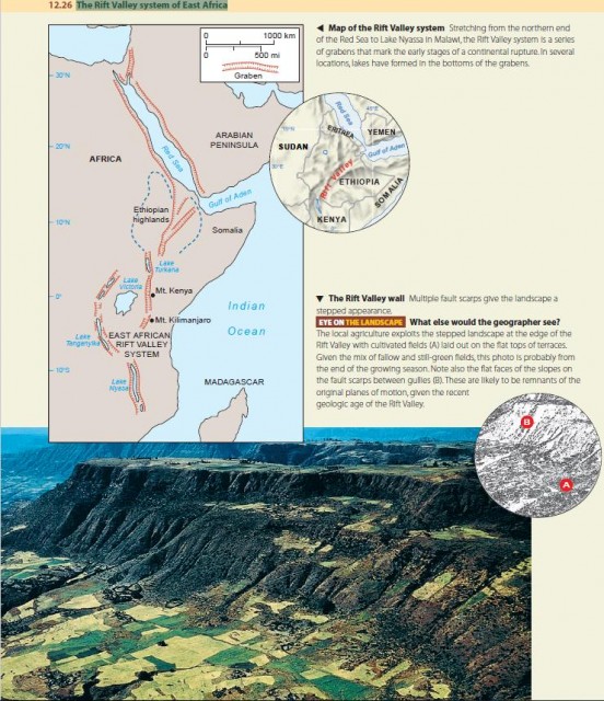
The sides of the rift valleys typically consist of fault scarps and multiple fault steps (Figure 12.26). Sediments from the adjacent plateaus make thick fills in the floors of the valleys. Two great stratovolcanoes have been built close to the Rift Valley east of Lake Victoria. One is Mount Kilimanjaro, whose summit rises to over 6000 m (about 19,000 ft). The other, Mount Kenya, is only a little lower and lies right on the Equator.