The Indian Ocean Tsunami of 2004
One of the most dangerous side effects of tectonic activity is the tsunami—a great ocean wave produced by an undersea earthquake or volcanic explosion. When a tsunami arrives at a coastline, it causes a temporary and rapid rise of sea level. Ocean waters rush landward and surge far inland, destroying coastal structures and killing inhabitants. After some minutes, the waters retreat, continuing the devastation. Several surging waves can follow one after the other.
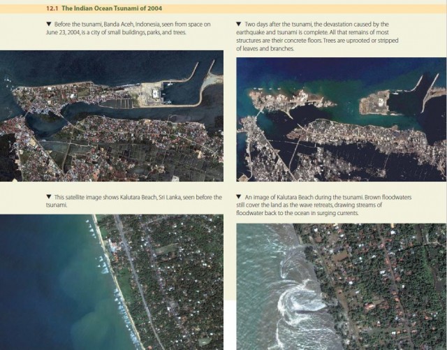
The most damaging tsunami recorded so far struck the Indian Ocean region in December 2004 following a massive undersea earthquake—9.0 on the Richter scale—in the Java trench, west of Sumatera. In Banda Aceh, a provincial capital about 230 km (140 mi) north of the epicenter, buildings toppled as residents ran into the streets. Hundreds died in the rubble, but then a giant tsunami washed over the city (Figure 12.1), killing thousands. As the wave moved down the Sumateran coastline, it killed many more, ultimately yielding an Indonesian death toll of more than 166,000.
It wasn't long before the wave began striking other coastlines. Thailand and Myanmar were hit first, and casualties were heavy on the packed beach resorts. The expanding wave, now traveling for two hours, next hit the eastern coast of Sri Lanka, devastating the entire coastal strip and killing at least 30,000 more. Soon after, India experienced the wave's wrath, reporting about 4000 dead in coastal cities and towns. About 6000 more deaths were recorded on the low islands of the Bay of Bengal.
It took three hours for the tsunami to reach the Maldives, a nation of low coral islands southwest of India, where about 100 lives were lost. After about six hours of travel time, the wave struck the coast of Africa. Damage was not as severe there as in Asia, but deaths were still recorded in Somalia, Kenya, and Tanzania. The wave was so powerful that it was still detectable with tide gauges as much as 36 hours later on reaching the Atlantic coasts of eastern North America and the Pacific islands of far-eastern Russia. The earthquake arose in the Java trench, a subduction zone where the Australia tectonic plate plunges beneath the Eurasia plate. About 1000 km (600 mi) of fault ruptured, causing the seafloor to move upward about 5 m (16 ft). It was this rapid motion of a vast area of ocean bottom that generated the tsunami.
In deep ocean waters, the tsunami's motion is normally too gentle to be noticed, making tsunamis hard to detect in the open ocean. As the wave approaches land, however, it “feels the bottom” and slows, causing the wave to steepen and shorten. Ocean water flows inland at speeds of up to 15 m/s (34 mi/hr) for several minutes. Considering that each cubic meter of sea water weighs about 1025 kg (64 lb/ft3), the power of the water surge is enormous.
No warning network was in place in the Indian Ocean to alert nations and their citizens of the impending disaster. One of the first efforts following the catastrophe was to start building such a network. With luck, the next great earthquake in the Java trench will find the world better prepared for its aftermath—another giant, deadly tsunami.
In July 2006, the Java trench rumbled again, this time with another undersea earthquake of magnitude 7.7 located 358 km (222 mi) south of Jakarta. The resulting 3-m (10-ft) tsunami was fortunately localized, but still about 1000 persons were killed or reported missing. In late September 2009, a 7.6-magnitude quake shook Padang, Sumatera, from an offshore epicenter westnorthwest of the city. Fortunately, no tsunami was reported, although about 2500 people were killed or injured. Located at the edge of the Pacific Ring of Fire, Indonesia is fated to continue to suffer earthquakes and tsunamis long into the future.