Kilimanjaro, Mount
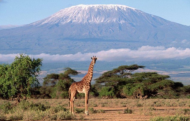
A MAJESTIC ROCKY GIANT, Mount Kilimanjaro is crowned by an icecap, impressively dominating the scenery. Mount Kilimanjaro towers above the Masai Steppe or the Great Rift Valley, which is believed to be the site of the origin of humankind. Pictures that shaped our imagination of East Africa are firmly connected to Kilimanjaro. The highest mountain of Africa is a volcanic massif situated in the territory of northeastern TANZANIA. The mountain consists of lava-dominated shield volcanoes and has three main volcanic centers, named Shira, Kibo, and Mawenzi. The highest point of the Kilimanjaro at the crater Kibo is called Uhuru Peak. At 19,340 ft (5,895 m) above sea level, it is Africa's highest elevation point. Mawenzi (east of Kibo) rises to 16,896 ft (5,149 m), and Shira (west of Kibo) to 13,000 ft (3,962 m).
Kilimanjaro is a very young volcanic massif: it started to grow less than 1 million years ago and ceased to grow about 450,000 to 300,000 years ago. Volcanic activity subsequently became sporadic, and today the inner crater of the Kibo shows only residual activity. The last blow of ash from the Kibo could be witnessed probably about 200 years ago. The volcanoes of the Kilimanjaro are part of a chain of Cenozoic volcanoes in East Africa. The major factors influencing the volcanic activity of this area are the PLATE TECTONICS of the East African Rift System (EARS), which marks the lines along which the eastern subplate is separating from western subplate.
Kilimanjaro rises from 2,297 ft (700 m) above sea level to its highest peak in a relatively confined space, which stretches from east to west about 53 mi (85 km) and from north to south about 50 mi (80 km). It is thus an ideal example of the geomorphologic and ecological change in different altitudes and is characterized by a distinctive differentiation of the natural area. Five major vegetation zones can be found at Kilimanjaro: the lower slopes; the tropical mist- and mountain-forest zone between 5,905 and 9,187 ft (1,800 to 2,800 m); the low alpine zone with heath and moorland; the highland desert; and the summit. Fertile volcanic soils and good climatic conditions allow a variety of crops to grow in the Kilimanjaro region. This resulted in manifold and diversified pre- and early-colonial agricultural activities of the Chagga, the native people who inhabit the region. The colonial and postcolonial agriculture focused increasingly on the industrialized production of the cash crops banana and coffee. The consequences subsequently led to a fundamental economical and structural change, extensive clearings and destruction of forest and pasture land, increasing erosion, and high population growth.
Another factor with major economic and ecological impact for the Kilimanjaro region is mountain tourism. Hans Meyer, a German colonial geographer and rich heir of a huge Leipzig publishing house, first ascended the Kibo crater in 1889 and called it Kaiser-Wilhelm-Spitze (since 1962, Uhuru Peak). Since this first ascent of Kilimanjaro, more and more mountaineers have been attracted by the mountain.
Each year, almost 20,000 tourists try to ascend the summit. Added to the high number of local guides and porters who are hired to succeed in this endeavor, a yearly total of more than 70,000 people climb up the mountain through ecologically sensitive terrain. Negative side effects of the economic benefits are the inevitable damages to the environment, although since the 1970s the main area of the Kilimanjaro enjoys the status of a national park. Moreover, for reasons of global warming, the impressive ice sheets and glaciers of the mountain (only 10 years ago, glaciers covered most of its summit) have been receding rapidly. More than 80 percent of the icecap that crowned the mountain when it was first thoroughly surveyed in 1912 is now gone. If recession continues at the present rate, it is projected that the glaciers of the Kilimanjaro, the last glaciers of Africa, are in serious threat of vanishing in the next 15 years.