St. Lawrence River
THE ST. LAWRENCE RIVER (in French, “fleuve Saint-Laurent”) was formed at the end of the last ice age. It is a 1,900-mi (3,058-km) west-to-east, middle latitude river connecting the five Great Lakes with the ATLANTIC OCEAN. The French called the river Riviere du Canada until the early 1600s, but fleuve connotes a river that runs to the sea, a more appropriate designation. Called Kaniatarowanenneh (Big Waterway) in the Mohawk dialect of the Iroquoian language, the river forms a portion of the border between NEW YORK State and the province of Ontario, CANADA, and bisects the province of Quebec.
GREAT LAKES OUTLET
The river is the outlet for the Great Lakes (the Inland Seas), the five connected freshwater lakes in east central North America that straddle the international border between Canada and the UNITED STATES. Collectively, these constitute the world's largest body of fresh water, with a water surface of 94,000 square mi (244,000 square km) and 5,500 cubic mi (23,000 cubic km) of water. From west to east, the lakes are SUPERIOR (the largest and deepest), MICHIGAN, HURON, ERIE (the shallowest), and ONTARIO (the smallest). Together, they extend about 850 mi (1,370 km) west to east and 700 mi (1,125 km) from north to south.
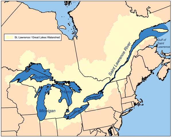
The St. Lawrence begins at the outflow of Lake Ontario at Kingston, Ontario, passing Montreal and Quebec City before draining into the Gulf of St. Lawrence, the world's largest estuary. The major islands include the Thousand Islands near Kingston; the Ile de Montreal; Ile Jesus (Laval); Ile d'Orleans, near Quebec City; and Anticosti Island north of the Gaspe Peninsula. Lake Champlain and the Ottawa, Richelieu, and Saguenay rivers drain into the St. Lawrence. The river widens to approximately 61 mi (100 km) beyond Quebec City.
Ancient inhabitants occupied the river area for at least 8,000 years and Algonquin and Iroquois tribes inhabited the river basin and adjacent uplands prior to European contact. On June 9, 1534, Jacques Cartier first sighted the river and claimed the region for Francis I. The completion of the 9.1-mi (14.5-km) Lachine Canal in 1825 allowed shipping to pass the rapids and navigate Lake Ontario.