Winds Aloft
We've looked at airflows at or near the Earth's surface, including both local and global wind patterns. But how does air move at the higher levels of the troposphere? Like air near the surface, winds at upper levels of the atmosphere move in response to pressure gradients and are influenced by the Coriolis effect.
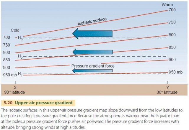
How do pressure gradients arise at upper levels? There is a simple physical principle that states that pressure decreases less rapidly with height in warmer air than in colder air. Also recall that the solar energy input is greatest near the Equator and least near the poles, resulting in a temperature gradient from the Equator to the poles. This gives rise to a pressure gradient (Figure 5.20).
THE GEOSTROPHIC WIND
How does a pressure gradient force pushing poleward produce wind, and what will the wind direction be? Any wind motion is subject to the Coriolis force, which turns it to the right in the northern hemisphere and to the left in the southern hemisphere. So, poleward air motion is toward the east, creating west winds in both hemispheres.
Unlike air moving close to the surface, an upper-air parcel moves without a friction force because it is so far from the source of friction—the surface. So, there are only two forces on the air parcel—the pressure gradient force and the Coriolis force.
Imagine a parcel of air, as shown in Figure 5.21. The air parcel begins to move poleward in response to the pressure gradient force. As it accelerates, the Coriolis force pulls it increasingly toward the right. As its velocity increases, the parcel turns increasingly rightward until the Coriolis force just balances the gradient force. At that point, the sum of forces on the parcel is zero, so its speed and direction remain constant. We call this type of airflow the geostrophic wind. It occurs at upper levels in the atmosphere, and we can see from the diagram that it flows parallel to the isobars.
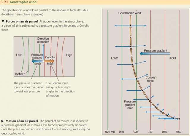
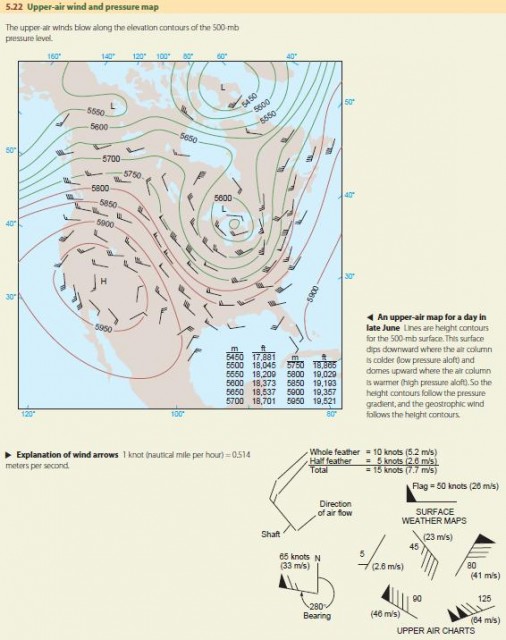
Figure 5.22 shows an upper-air map for North America on a late June day. A large, upper-air low is centered over the Great Lakes. Since low pressure aloft indicates cold air (Figure 5.20), this is a mass of cool Canadian air that has moved southward to dominate the eastern part of the continent. A large, but weaker, upper-air high is centered over the southwestern desert. This will be a mass of warm air, heated by intense surface insolation on the desert below.
The geostrophic wind flow, shown by the wind arrows, follows the contours closely. It is strongest where the contours are closest together, because there the pressure gradient force is strongest. The wind around the upper-air low also tends to spiral inward and converge on the low. The converging air descends toward the surface, where surface high pressure is present, and then spirals outward. Similarly, the wind around the upper-air high spirals outward and diverges away from the center. At the surface, low pressure causes air to spiral inward and upward.
GLOBAL CIRCULATION AT UPPER LEVELS
Figure 5.23 sketches the general airflow pattern at higher levels in the troposphere. It has four major features—a polar low, upper-air easterlies, tropical high-pressure belts, and weak equatorial westerlies. We've seen that the general temperature gradient from the tropics to the poles creates a pressure gradient force that generates westerly winds in the upper atmosphere. These upper-air westerlies blow in a complete circuit about the Earth, from about 25° lat. almost to the poles, often undulating from their westerly track.
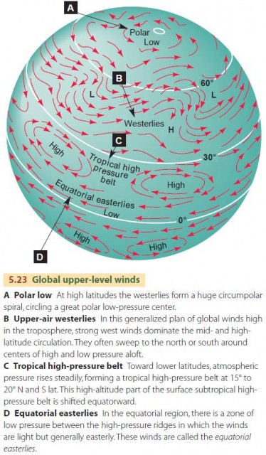
So, the overall picture of upper-air wind patterns is really quite simple—a band of weak easterly winds in the equatorial zone, belts of high pressure near the Tropics of Cancer and Capricorn, and westerly winds, with some variation in direction, spiraling around polar lows.
JET STREAMS AND THE POLAR FRONT
Jet streams are wind streams that reach great speeds in narrow zones at a high altitude. They occur where atmospheric pressure gradients are strong. Along a jet stream, the air moves in pulses along broadly curving tracks. The greatest wind speeds occur in the center of the jet stream, with velocities decreasing away from it.
There are three kinds of jet streams. Two are westerly streams, and the third is a weaker jet with easterly winds that develops in Asia as part of the summer monsoon circulation. These are shown in Figure 5.24A. The most poleward type of jet stream is located along the polar front. It is called the polar-front jet stream (or simply the “polar jet”) (Figure 5.24B).
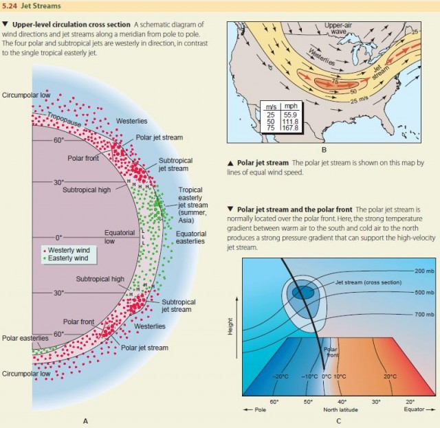
The polar jet is generally located between 35° and 65° latitude in both hemispheres. It follows the boundary between cold polar air and warm subtropical air (Figure 5.24C). It is typically found at altitudes of 10 to 12 km (about 30,000 to 40,000 ft), and wind speeds in the jet range from 75 to as much as 125 m/s (about 170 to 280 mi/hr).
The subtropical jet stream occurs at the tropopause, just above subtropical high-pressure cells in the northern and southern hemispheres. There, westerly wind speeds can reach 100 to 110 m/s (about 215 to 240 mph), associated with the increase in velocity that occurs as an air parcel moves poleward from the Equator.
The tropical easterly jet stream occurs at even lower latitudes. It runs from east to west—opposite in direction to that of the polar-front and subtropical jet streams. The tropical easterly jet occurs only in summer and is limited to a northern hemisphere location over Southeast Asia, India, and Africa.
DISTURBANCES IN THE JET STREAM
While the jet stream is typically a region of confined, high-velocity westerly winds found in the midlatitudes, the jet stream can actually contain broad wavelike undulations called jet stream disturbances. These are sometimes also called Rossby waves, after Carl-Gustaf Rossby, a Swedish-American meteorologist who first observed and studied them.
Many processes can produce disturbances in the eastward flow of the jet stream. One of the most important is related to baroclinic instability, which makes the atmosphere unstable to small disturbances in the jet stream and allows these disturbances to grow over time. (The word “baroclinic” comes from the prefix baro-, meaning pressure, and the suffix cline, meaning gradient.)
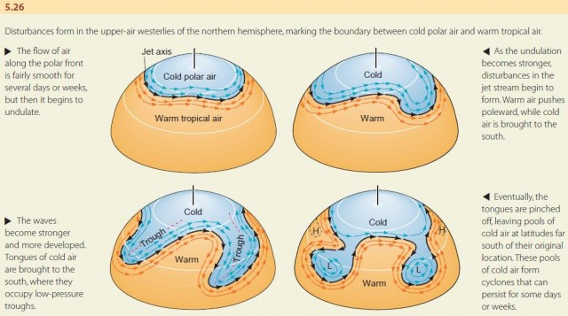
The development of these disturbances is shown in Figure 5.26. For a period of several days or weeks, the jet stream flow may be fairly smooth. Then, an undulation develops. As the undulation grows, warm air pushes poleward, while a tongue of cold air is brought to the south. Eventually, the cold tongue is pinched off, leaving a pool of cold air at a latitude far south of its original location. This cold pool may persist for some days or weeks, slowly warming with time. Because of its cold center, it will contain low pressures aloft. In addition, the cold air in the core will descend and diverge at the surface, creating surface high pressure. Similarly, a warm air pool will be pinched off far to the north of its original location. Within the core of the warm pool will be rising air, with convergence and low pressure at the surface, as well as high pressure aloft.
What causes a jet stream disturbance to grow over time? This growth is actually a complicated process and involves the interaction of the upper-air circulations— formed by the high- and low-pressure centers with the global temperature gradient between the warmer, low-latitude air and colder, high-latitude air. This growth process is described in Figure 5.27.
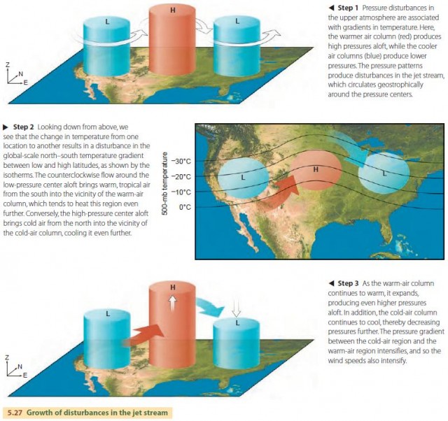
Consider first what happens to a slight disturbance in the jet stream. These disturbances arise from pressure differences between one location and another, resulting in geostrophic wind variations. In addition, the pressure differences are accompanied by temperature differences, with high pressures aloft found over regions of warm air and low pressures aloft over regions of cool air.
As air circulates around these disturbances, the counterclockwise circulations associated with the lowpressure system bring warm, low-latitude air into a region that is already warm. In contrast, the clockwise circulation around the high-pressure region brings cold, high-latitude air into a region that is already cold. As a result, the warm regions tend to get warmer and the cold regions tend to get colder. In turn, the high pressures associated with the warm-air region tend to get higher and the low pressures associated with the coldair region tend to get lower. This process intensifies the pressure gradient between the two regions, resulting in stronger winds and an even larger disturbance.