Midlatitude Anticyclones and Cyclones
Air masses are set in motion by wind systems—typically, masses of air moving in a spiral. Air can spiral inward and converge in a cyclone, or spiral outward and diverge in an anticyclone. Most types of cyclones and anticyclones are large features spanning hundreds to thousands of kilometers that move slowly across the Earth's surface, bringing changes in the weather as they move. These are referred to as traveling cyclones and anticyclones.
ANTICYCLONES
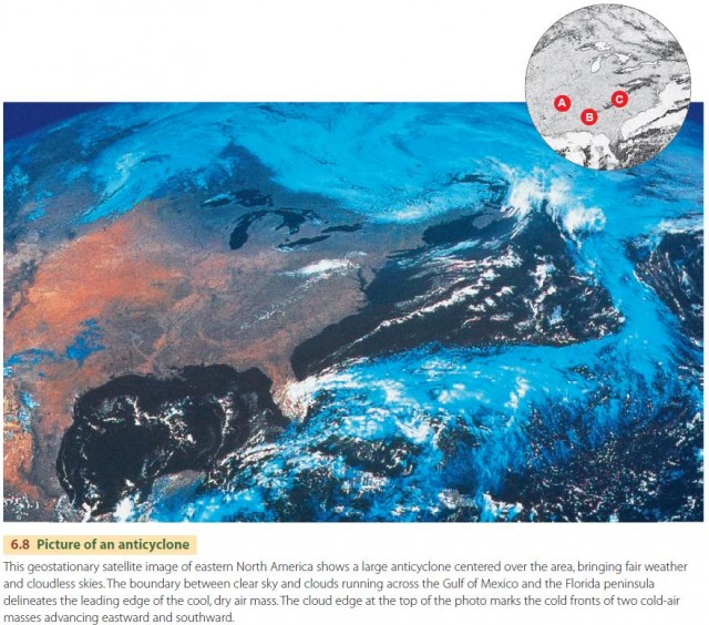
Anticyclones are associated with fair skies, except for occasional puffy cumulus clouds that sometimes develop in a moist surface air layer. For this reason, we often call anticyclones fair-weather systems. Within a traveling anticyclone, the air is warmed adiabatically as it descends and diverges, so condensation does not occur. Toward the center of an anticyclone, the pressure gradient is weak, so winds are light and variable. We find traveling anticyclones in the midlatitudes, typically associated with ridges or domes of clear, dry air that move eastward and equatorward. Figure 6.8 shows an example of a large anticyclone centered over eastern North America, bringing fair weather and cloudless skies to the region.
CYCLONES
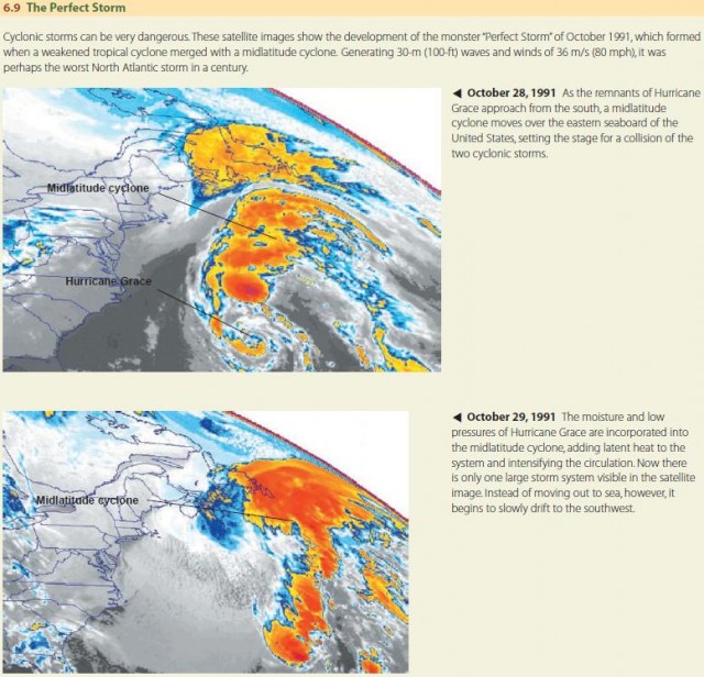
In a cyclone, the air converges and rises, cooling adiabatically as it does so. If the cooling air reaches saturation, this can cause condensation leading to precipitation. Many cyclones are weak and pass overhead with little more than a period of cloud cover and light precipitation. However, some cyclones have very intense pressure gradients associated with them that generate strong, intense winds. In addition, the inspiraling motion associated with these winds can result in significant convergence, and heavy rain or snow can accompany the cyclone. In that case, we call the disturbance a cyclonic storm, described in Figure 6.9.
There are three types of traveling cyclones. First is the midlatitude cyclone of the midlatitude, subarctic, and subantarctic zones, sometimes also called an extratropical cyclone. These cyclones range from weak disturbances to powerful storms. Second is the tropical cyclone found in the tropical and subtropical zones. Tropical cyclones range from mild disturbances to highly destructive hurricanes or typhoons. A third type is the tornado, a small, intense cyclone of enormously powerful winds. The tornado is much smaller in size than other cyclones and is related to strong, localized convective activity.
MIDLATITUDE CYCLONES
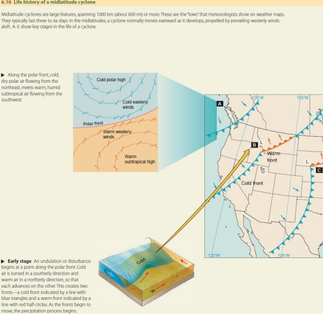
The midlatitude cyclone is the dominant weather system in middle and high latitudes. It is a large inspiraling of air that repeatedly forms, intensifies, and dissolves along the polar front.
The polar front sits between two large anti cyclones— the polar high to the north, with its cold, dry air mass, and the subtropical high, with its warm, moist air mass, to the south. At the polar front, the airflow converges from opposite directions, with northeasterly winds to the north of the polar front and southwesterly winds to the south of the polar front.
These wind motions lead to a counterclockwise, or cyclonic, circulation that creates a low-pressure trough between the two high-pressure cells. Midlatitude cyclones are local intensifications of cyclonic circulation that move along this low-pressure trough. The circular motion of air around the cyclone generates warm and cold fronts that sweep across large regions, creating weather changes. Figure 6.10 shows the life history of a midlatitude cyclone and associated warm and cold fronts and explains how a midlatitude cyclone forms, grows, and eventually dissolves.
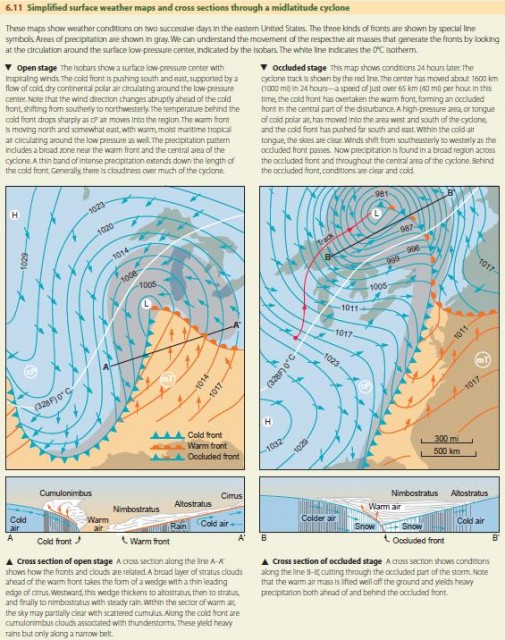
How does weather change as a midlatitude cyclone passes through a region? As the midlatitude cyclone and its accompanying fronts move eastward, a fixed location—like a point south of the Great Lakes—can experience weather ranging from warm, mild conditions with light winds to periods of heavy precipitation with gusty winds to cold, dry, breezy conditions with clear skies overhead. All of these can take place in a span of 24–36 hours as the fronts pass through. We can see these changes in Figure 6.11.
MIDLATITUDE CYCLONES AND UPPER-AIR DISTURBANCES
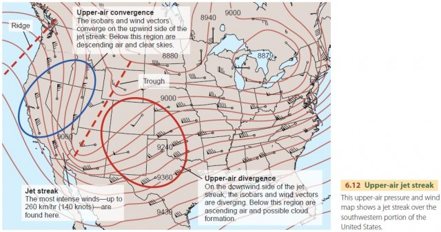
What causes midlatitude cyclones to grow over time? This growth is actually related to the growth of jet stream disturbances, which we explained in Chapter 5. To understand this process, look at the upper-level wind and pressure map in Figure 6.12. As the jet stream moves southward and eastward between the high-pressure disturbance—or ridge—and low-pressure disturbance—or trough—in the upper atmosphere, it tends to squeeze together or converge. As it does so, the winds around the low-pressure accelerate, forming a jet streak. On the eastward side of the low pressure, the winds slow down as they spread apart or diverge.
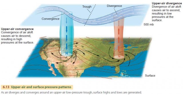
As the air aloft converges on the upwind side of the jet streak, it produces a descent of air toward the surface. The descending air subsequently produces an anticyclone (or high-pressure center) at the surface, as seen in Figure 6.13. Conversely, as the air diverges on the downwind side of the jet streak, air ascends from below, resulting in a cyclone (or low-pressure center) at the surface.
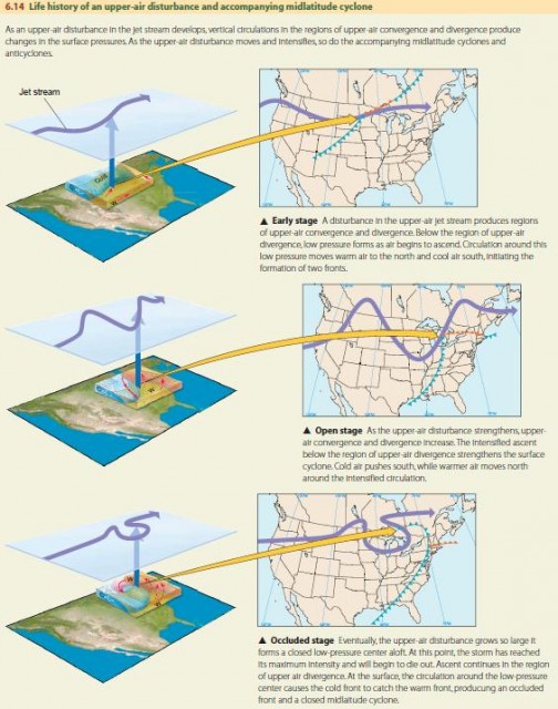
Thus, the life history of the low-level midlatitude cyclone and its accompanying fronts follows the life history of the jet stream disturbance, as shown in Figure 6.14. As the upper-air circulation disturbance intensifies and moves eastward, the vertical circulations cause the midlatitude cyclones and anticyclones at the surface to intensify and move along with the disturbance. Eventually, the upper-air jet stream disturbance gets so large it causes the jet stream to circle back on itself, pinching off the upperair low-pressure center and reestablishing the east–west flow of the jet stream. At the surface, we recognize this as the point at which the midlatitude cyclone occludes and reestablishes the polar front.
CYCLONE TRACKS AND CYCLONE FAMILIES
Several important processes can initiate traveling midlatitude cyclones, as seen in Figure 6.15. These processes link upper-air pressure patterns to surface patterns through vertical circulations induced by convergence and divergence, as explained above. The Aleutian and Icelandic lows are regions of frequent jet stream disturbances that spawn eastward-moving cyclones. Disturbances in the upper air flow caused by mountain chains produce lee-side troughs that also produce cyclones. Land–sea coastal boundaries are often regions of strong temperature contrast that can trigger disturbances and cyclones as well. As the disturbances propagate downwind, their cyclones move as well, and thus the surface storms are “dragged” along by the upper-air steering winds.
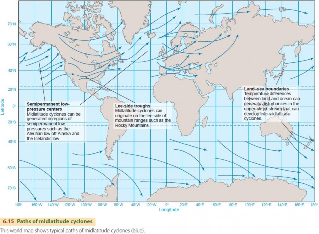
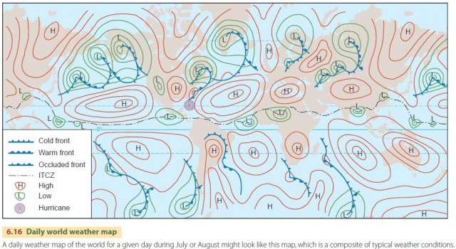
Because midlatitude cyclones tend to form in certain areas, they tend to travel common paths, called storm tracks, as they develop, mature, and dissolve. Cyclones of the Aleutian and Icelandic lows commonly form in succession, traveling as a chain across the North Atlantic and North Pacific oceans. A world weather map, such as in Figure 6.16, shows several such cyclone families. Each midlatitude cyclone moves northeastward along the storm track, deepening in low pressure and eventually occluding. For this reason, intense cyclones arriving at the western coasts of North America and Europe are usually occluded, while those arriving on the eastern seaboard after originating on the lee side of the Rocky Mountains are still intensifying.
In the southern hemisphere, storm tracks are more nearly along a single lane, following the parallels of latitude. Three such cyclones are shown in Figure 6.16. This track is more uniform because of the uniform pattern of ocean surface circling the globe at these latitudes. Only the southern tip of South America projects southward to break the monotonous expanse of the Southern Ocean.
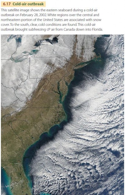
COLD-AIR OUTBREAKS
Another distinctive weather feature of midlatitude weather systems is the occasional penetration of powerful tongues of cold polar air from the midlatitudes into very low latitudes. These tongues are known as cold-air outbreaks. The leading edge of a cold-air outbreak is a cold front with squalls, which is followed by unusually cool, clear weather with strong, steady winds. The cold-air outbreak is best developed in the Americas. Outbreaks that move southward from the United States into the Caribbean Sea and Central America are called northers or nortes, whereas those that move north from Patagonia into tropical South America are called pamperos. Figure 6.17 shows one such outbreak over North America. A severe polar outbreak may bring subfreezing temperatures to the low latitudes of both regions and damage tropical crops such as citrus and coffee.