How Do Mid-Latitude Cyclones Move and Evolve?
ONCE FORMED, MID-LATITUDE CYCLONES migrate across the surface and commonly evolve through a series of steps, due to the way that winds circulate around the area of low pressure. Circulation around the cyclone will steer the trailing fronts in a counterclockwise direction (in the Northern Hemisphere), while west-to-east motion of the westerlies and Rossby waves shift the entire storm system from west to east. Here, we examine the life stages of a mid-latitude cyclone as it moves west-to-east across North America.
What Are the Three Stages in the Life Cycle of a Mid-Latitude Cyclone?
Formation (Cyclogenesis)
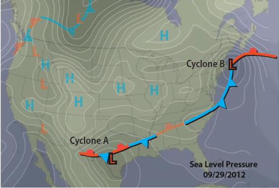
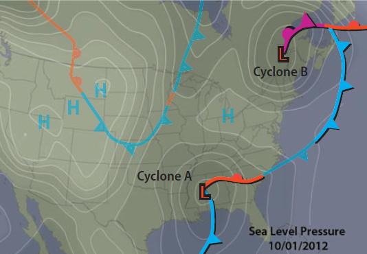
The map on the left shows several fronts as decorated lines, areas of high and low pressure, and isobars as thin lines. A mid-latitude cyclone begins when a relatively cold air mass and a warmer one meet along a frontal boundary. Here, cold and warmer air masses meet along a stationary front labeled “Cyclone A.”
At some point along this boundary, a small amount of surface convergence occurs because of local circulation features that push one air mass into the other, because of topographic influences, or by some other local mechanism. This convergence causes the low pressure to intensify.
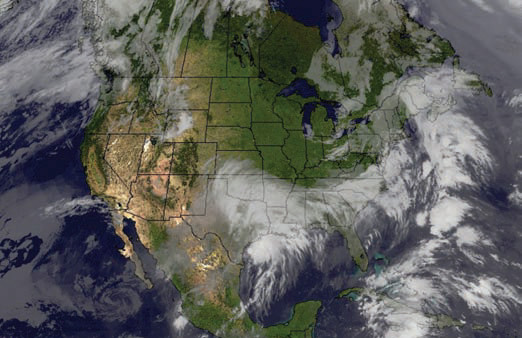
This satellite image shows clouds and precipitation at the same time as represented by the weather map on the left. Note that the clouds and precipitation are associated with both cyclones on this map (cyclone A over Texas, and cyclone B over New England).
Maturity
At a later time, the low pressure has moved east and intensified with a stronger pressure gradient, causing more surface air to move toward it. As this air begins to converge from all directions, the Coriolis effect causes the air to have an apparent deflection to the right. This results in counterclockwise flow that pushes cold air southward, turning one segment of the stationary front into an eastwardadvancing cold front.
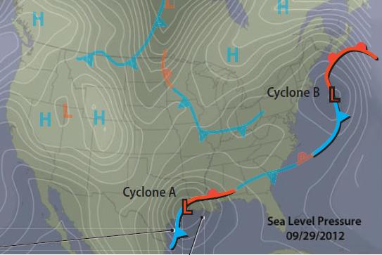
On the other side (east of the low), warm air pushes northward, forming a north-moving warm front. The movement of the two air masses causes a clear bend in the front, an indication that cyclone A has matured into a mid-latitude cyclone. Note that cyclone B, now east of the continent, has a more curved shape than cyclone A, an indication that it is even more mature.
Both cyclones are visible in the satellite image above. Although not obvious on this image, cyclone A now has distinct cold, warm, and cool sectors of air. The “cold” sector is behind (west of ) the cold front, whereas the “warm” sector is behind (south of ) the warm front. The cool sector is in front of (north of ) the warm front — neither the warm front nor the cold front have passed through this sector. On the satellite image, dense cumuliform clouds (along the south edge of the image) form along the cold front, while indistinct stratiform clouds form along the warm front and in the cool sector. Advancing cold air can easily displace warmer air, but the warmer air has more difficulty moving the cool air; with time the cold front advances faster than the warm front, as in cyclone B.
Occlusion
1. With time, the westerlies push both weather systems toward the east or northeast. Eventually, the cold fronts will catch up with, and even overtake, the warm fronts as both flow counterclockwise around the low-pressure areas. When this happens, the warmer air mass is lifted above the surface, because it is less dense than both the cold air and the “cool” air. This process is called occlusion, and a front that has experienced occlusion is an occluded front. In occlusion, the moisture is moved counterclockwise around the low, so that the heaviest precipitation may be northwest of the low.
2. Occluded fronts, like that near cyclone B on the map above, are purple on weather maps with the triangles and semicircles pointing in the direction that the system is moving. Though many mid-latitude cyclones never occlude, occlusion often, but not always, signals the end of the mid-latitude cyclone's life, because by this time the cold air has warmed and the warm air has cooled. Some occluded fronts can continue to strengthen for some time.
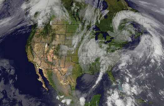
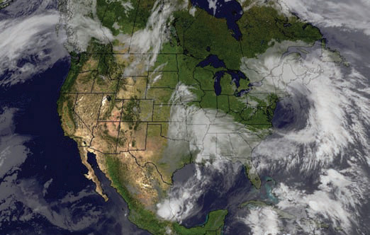
3. Notice on the satellite image that the sky over the occluded front is filled with clouds. The cumuliform cloudiness associated with the cold front more or less merges with the stratiform clouds associated with the warm front. Occluded fronts, however, can have a wide variety of cloudy features.
4. This figure contains three cross sections that capture different stages in the process of occlusion. Occlusion begins nearest to the low-pressure core because there the cold front has the least distance to catch up to the warm front, and it proceeds away from the low over time. To visualize what occurs, move through the three cross sections, which represent different places, but also successive stages in the occlusion process.
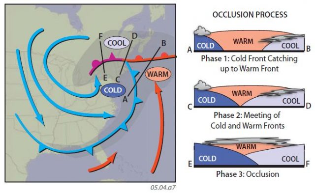
5. In this cross section, the cold front is moving to the east and the warm front is moving to the north, but the cold front is moving faster and so it is getting closer to the warm front.
6. Here, the cold front has caught up with the warm front, trapping the warm, moist air above the mass of cold air and the mass of cool air, which are in the process of joining together.
7. At segment EF, the two air masses are fully beneath the warm air, lifting it higher. As the warm air is forced up, it cools, forming clouds and precipitation. The air north of the warm front is cool but not cold because it is blocked from receiving a fresh supply of cold air from the air mass to the west.
How Do the Great Lakes Interact with Cyclones?
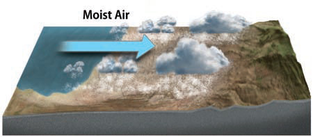
The Great Lakes in the north-central part of the U.S. are famous for interacting with winter storms, producing intense snowfall called lake-effect snows. The largest amounts of lake-effect snow occur after mid-latitude cyclones and associated cold fronts have moved eastward across the Great Lakes, and higher pressure behind them begins to approach the area. The circulation over the water causes moist air to flow onto land and dump huge amounts of snow on land south and east of the lakes, including the cities of Syracuse and Buffalo in upstate New York.
As a cyclone moves across one of the lakes, it encounters water temperatures that are somewhat warmer than the air or the surrounding land. This is largely due to water changing temperature more slowly than air or land from fall to winter. In winter, especially early winter, the Great Lakes are much warmer than the air above them or the land beside them. This causes steep environmental lapse rates, destabilizing the atmosphere and strengthening a cyclone passing over the Great Lakes.
Having flowed across the Great Lakes, the moist, destabilized air is pushed inland by an approaching anticyclone, depositing snow on adjacent downwind land, especially where topography, such as the mountains of upstate New York, cause orographic enhancement.