Why Does Weather Change?
THE ATMOSPHERE IS SO THIN that a single regional mass of cold or warm air can dominate the entire vertical extent of the troposphere. With time, such cold or warm air masses can expand or shrink, become colder or warmer, and can remain stationary or move great distances. In the narrow zone where the two air masses meet, weather conditions can change drastically across short distances and times.
What Are Some Fundamental Controls of Weather?
Weather is controlled by the processes described in previous parts of this book, and in fact those processes were described to get to this point — an understanding of weather and climate. Weather is a response to variations of insolation and resulting energy imbalances, to large-scale motion in the atmosphere, and to the important role of atmospheric moisture, including latent heat. Here, we briefly review the large-scale circulation patterns. Only the Northern Hemisphere is shown below, but similar patterns are also present in the Southern Hemisphere.
The most important features that control weather are the huge circulation cells that essentially divide each hemisphere into thirds (by latitude, not by area). Areas at high latitudes, poleward of approximately 60°, are under the effect of the polar cell and polar easterlies. High pressure dominates the pole.
The edge of the polar cell is marked by the polar front jet stream, a belt of high-speed winds that encircle the globe from west to east, high above the surface. The surface in this area has changeable and stormy weather due to rising air. Bends in the polar front jet stream are called Rossby waves, which exert a strong control on many weather systems.
A second jet stream, called the subtropical jet stream, encircles the globe (also west to east) high above the surface near 30° latitude. Between this jet stream and the equator, near-surface winds blow from the northeast, forming the northeast trade winds. Along the equator, high amounts of insolation-related heating cause rising air and associated low pressure. Winds converge from both sides of the equator, forming the Intertropical Convergence Zone (ITCZ).
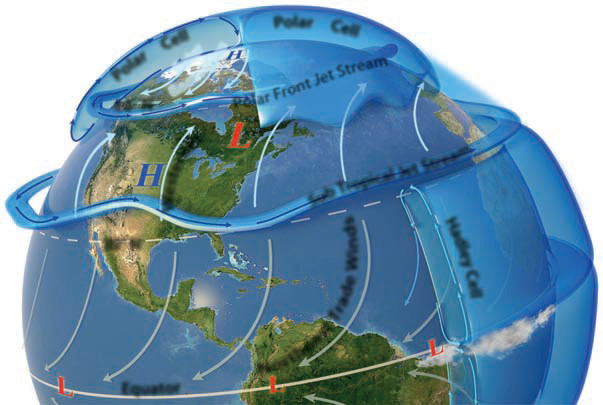
Between the two jet streams, in the mid-latitudes and part of the subtropics, the general circulation is from the west — the westerlies. There is not a well-established, upper-level circulation cell over this region.
Between the subtropical jet stream and ITCZ is the Hadley cell, fed by rising air in the ITCZ. The cell descends in the subtropics, causing the subtropical highs (high pressure), with their associated normally dry conditions.
What Is an Air Mass?
The pattern of global circulation helps form large bodies of air, called air masses, that have relatively uniform temperatures and moisture over large horizontal distances. We identify different types of air masses according to their temperature, moisture, and geographic characteristics.
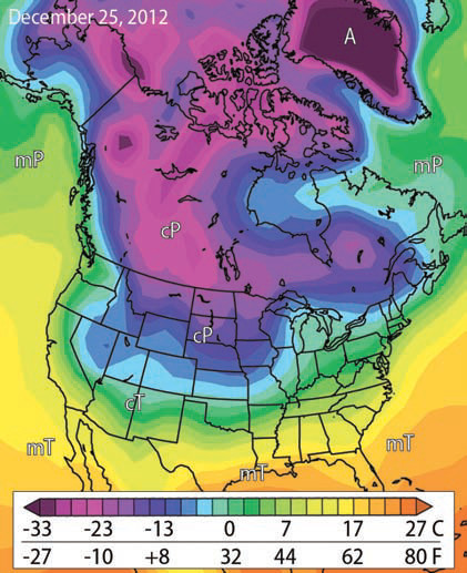
The air-temperature map to the right depicts a cold air mass, represented by purple and blue, over the northern part of North America, including the northern Great Plains. A warmer air mass exists farther south, covering most of the southern and eastern U.S. The boundary between the two air masses is along the steep color gradient (a large change in color over a short distance) between the purple and blue-green areas.
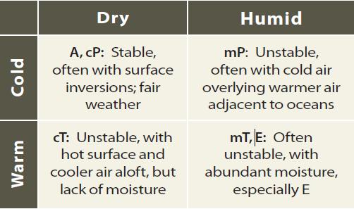
The classification system for air masses uses a two-letter abbreviation. The first letter is lowercase and signifies the moisture characteristics, where “c” is for continental (dry) and “m” is for “maritime” (humid). The second letter is uppercase and refers to the temperature characteristics: “A” for Arctic (or Antarctic), “P” for polar (somewhat warmer than Arctic), “T'” for tropical, and “E” for equatorial. An “A” air mass is inherently continental (dry), because water in such areas is often frozen. An “E” air mass is inherently maritime, because so much of the air at equatorial latitudes is over or near a source of water.
Continental Air Masses
Hot, dry air masses, typically occurring over land, are continental tropical (cT) air masses. Note that cT air masses occur in the Desert Southwest of North America, southeastern South America, the Sahara and Arabian Deserts, Tibet, and central Australia. In areas under the influence of cT air masses, conditions can be oppressively hot and dry for many months during the year.
Arctic or Antarctic (A) air masses are formed near the North and South Poles. Not only are they extremely cold, but they are also very dry because the water-vapor capacity is low in such cold environments. Cold, dense air has a tendency to sink, and therefore, these air masses reinforce the region of polar high pressure (polar high) that resides over each pole. Surface winds near the pole move east-to-west, so the surface A air masses tend to be steered westward as they drift away from the poles. The paths of A air masses can also be affected by curves in the upper-level polar front jet stream (Rossby waves), which can steer an A air mass toward the northern U.S. or into central Eurasia. These are the “Arctic blasts” that bring very cold air into the northern U.S.
Continental polar (cP) air masses are located farther away from the poles than A air masses. They are cold and dry, but less so than A air masses. cP air masses form over cold, inland areas, like northern Canada, Siberia, Mongolia, and north-central Europe. The southern edge of cP air masses is the polar front. In the winter, cP air masses can move significant distances equatorward, bringing cold air into the U.S. and southern Eurasia. In the summer, cP air masses are not as cold and do not reach as far south.
Maritime Air Masses
Due to their proximity to the equator, equatorial (E) air masses are very warm and moist. The high temperature and moisture support instability to great heights in the atmosphere, resulting in tropical clouds and storms. Storm development is aided by the general circulation of the atmosphere, which in equatorial regions promotes rising of the air, especially along the ITCZ.
Maritime tropical (mT) air masses form over warm, oceanic regions. mT air masses are warm and moist, and they have influence over much of the Earth because so much of the world (particularly in the low latitudes) is covered by ocean. For example, mT air tends to make most of the Atlantic Ocean and adjacent eastern U.S. warm and humid in summer. mT air masses are commonly near the subtropics and under the high pressure associated with this region.
Maritime polar (mP) air masses are cool and humid. They are not as cold as cP air masses because oceanic regions are not as cold as continental areas at the same latitude, particularly in winter. mP air masses are a cold, damp influence in places like Seattle and most of western Europe, as the westerlies push the cool, damp air eastward from their oceanic source region.
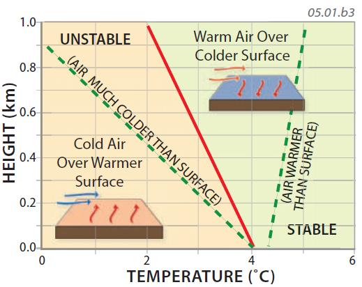
Any air mass acquires characteristics of the region where it forms — its source region. Air masses that form inland or over frozen ocean areas (e.g., cP) will be dry, whereas air masses that form over oceans (e.g., mT ) will be humid. Air masses that form in the low latitudes will generally be warmer than those that form over high latitudes. When an air mass migrates from its source region across a different region, its temperature and moisture will be modified, which can in turn affect the lapse rate, stability of the air, and how much mixing occurs within the air mass.